Home > Arts > Artists > B > Charles Marie Rigobert Bonne
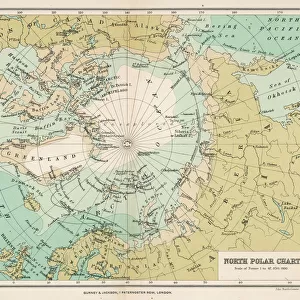
Map of the Russian Empire, in Europe and Asia, from Atlas de Toutes les Parties

![]()
Wall Art and Photo Gifts from Fine Art Finder
Map of the Russian Empire, in Europe and Asia, from Atlas de Toutes les Parties
KW205830 Map of the Russian Empire, in Europe and Asia, from Atlas de Toutes les Parties Connues du Globe Terrestre by Guillaume Raynal (1713-96), published J L Pellet, Geneva, 1780 (coloured engraving) by Bonne, Charles Marie Rigobert (1727-95); Private Collection; Ken Welsh; French, out of copyright
Media ID 12755318
© www.bridgemanimages.com
Arctic Circle North Pole Siberia Tartar
FEATURES IN THESE COLLECTIONS
> Arts
> Artists
> B
> Charles Marie Rigobert Bonne
> Asia
> Related Images
> Europe
> Russia
> Related Images
> Fine Art Finder
> Artists
> Charles Marie Rigobert Bonne
> Maps and Charts
> Related Images
EDITORS COMMENTS
This print showcases a historical treasure, the "Map of the Russian Empire, in Europe and Asia" taken from Guillaume Raynal's renowned Atlas de Toutes les Parties Connues du Globe Terrestre. Published in 1780 by J L Pellet in Geneva, this coloured engraving by Charles Marie Rigobert Bonne offers a fascinating glimpse into the vast territories of Russia during that era. The intricate details on this map take us on an immersive journey through time and space. From Siberia to Tartar, from the Arctic Circle to the North Pole, every corner of this expansive empire is meticulously depicted. The borders and boundaries are clearly marked, allowing us to appreciate the sheer magnitude of Russia's dominion over both Europe and Asia. As we gaze upon this antique masterpiece, we can't help but marvel at its historical significance. It serves as a testament to human curiosity and exploration during an age when cartography was still evolving. This particular print captures not only geographical accuracy but also artistic beauty with its vibrant colors and delicate engravings. Displayed within a private collection today, it reminds us of how knowledge has been passed down through generations thanks to dedicated individuals like Raynal and Bonne. This photograph preserves their legacy while inviting us to reflect on our own place within history's grand tapestry.
MADE IN THE UK
Safe Shipping with 30 Day Money Back Guarantee
FREE PERSONALISATION*
We are proud to offer a range of customisation features including Personalised Captions, Color Filters and Picture Zoom Tools
SECURE PAYMENTS
We happily accept a wide range of payment options so you can pay for the things you need in the way that is most convenient for you
* Options may vary by product and licensing agreement. Zoomed Pictures can be adjusted in the Basket.