Framed Print > Fine Art Finder > Artists > Charles Marie Rigobert Bonne
Framed Print : Map of the Russian Empire, in Europe and Asia, from Atlas de Toutes les Parties


Please select a smaller print size for this image
![]()
Framed Photos from Fine Art Finder
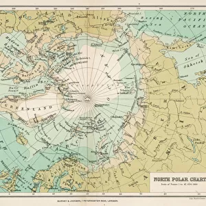
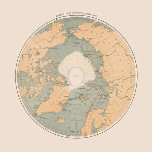
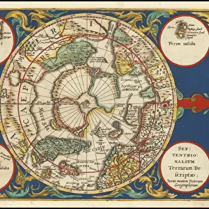
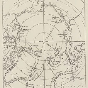
Map of the Russian Empire, in Europe and Asia, from Atlas de Toutes les Parties
KW205830 Map of the Russian Empire, in Europe and Asia, from Atlas de Toutes les Parties Connues du Globe Terrestre by Guillaume Raynal (1713-96), published J L Pellet, Geneva, 1780 (coloured engraving) by Bonne, Charles Marie Rigobert (1727-95); Private Collection; Ken Welsh; French, out of copyright
Media ID 12755318
© www.bridgemanimages.com
Arctic Circle North Pole Siberia Tartar
22"x18" (58x48cm) Modern Frame
Discover the grandeur of the historic Russian Empire with our exquisite Framed Prints from Media Storehouse. This stunning Map of the Russian Empire, in Europe and Asia, hails from the renowned Atlas de Toutes les Parties by Guillaume Raynal and J L Pellet. Dating back to the 18th century, this intricately detailed map showcases the vast expanse of the Russian Empire during its height, with Europe and Asia beautifully rendered. Bring a touch of history and sophistication to your home or office with our high-quality Framed Prints, perfect for those who appreciate the beauty of antique cartography and the rich history of Russia.
Wood effect frame, card mounted, 16x12 archival quality photo print. Overall outside dimensions 22x18 inches (58x48cm). Environmentally and ozone friendly, 40mm wide x 15mm Polycore® moulding has the look of real wood, is durable and light and easy to hang. Biodegradable and made with non-chlorinated gases (no toxic fumes) it is efficient; producing 100 tons of polystyrene can save 300 tons of trees! Prints are glazed with lightweight, shatterproof, optical clarity acrylic (providing the same general protection from the environment as glass). The back is stapled hardboard with a sawtooth hanger attached. Note: To minimise original artwork cropping, for optimum layout, and to ensure print is secure, the visible print may be marginally smaller
Contemporary Framed and Mounted Prints - Professionally Made and Ready to Hang
Estimated Image Size (if not cropped) is 39.6cm x 26.3cm (15.6" x 10.4")
Estimated Product Size is 57.9cm x 47.8cm (22.8" x 18.8")
These are individually made so all sizes are approximate
Artwork printed orientated as per the preview above, with landscape (horizontal) orientation to match the source image.
EDITORS COMMENTS
This print showcases a historical treasure, the "Map of the Russian Empire, in Europe and Asia" taken from Guillaume Raynal's renowned Atlas de Toutes les Parties Connues du Globe Terrestre. Published in 1780 by J L Pellet in Geneva, this coloured engraving by Charles Marie Rigobert Bonne offers a fascinating glimpse into the vast territories of Russia during that era. The intricate details on this map take us on an immersive journey through time and space. From Siberia to Tartar, from the Arctic Circle to the North Pole, every corner of this expansive empire is meticulously depicted. The borders and boundaries are clearly marked, allowing us to appreciate the sheer magnitude of Russia's dominion over both Europe and Asia. As we gaze upon this antique masterpiece, we can't help but marvel at its historical significance. It serves as a testament to human curiosity and exploration during an age when cartography was still evolving. This particular print captures not only geographical accuracy but also artistic beauty with its vibrant colors and delicate engravings. Displayed within a private collection today, it reminds us of how knowledge has been passed down through generations thanks to dedicated individuals like Raynal and Bonne. This photograph preserves their legacy while inviting us to reflect on our own place within history's grand tapestry.
MADE IN THE UK
Safe Shipping with 30 Day Money Back Guarantee
FREE PERSONALISATION*
We are proud to offer a range of customisation features including Personalised Captions, Color Filters and Picture Zoom Tools
SECURE PAYMENTS
We happily accept a wide range of payment options so you can pay for the things you need in the way that is most convenient for you
* Options may vary by product and licensing agreement. Zoomed Pictures can be adjusted in the Basket.