Photographic Print > Universal Images Group (UIG) > Universal Images Group > Satellite and Aerial > Planet Observer 6
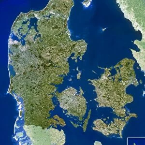
Photographic Print : Denmark, Satellite Image


![]()
Photo Prints from Universal Images Group (UIG)
Denmark, Satellite Image
Satellite view of Denmark. This image was compiled from data acquired by LANDSAT satellite
Universal Images Group (UIG) manages distribution for many leading specialist agencies worldwide
Media ID 9608795
© Planet Observer
Alsace Bas Rhin Geographical Border Relief Map Satellite View
10"x8" (25x20cm) Photo Print
Discover the breathtaking beauty of Denmark from a new perspective with our Media Storehouse Photographic Prints. This stunning Satellite Image, captured by LANDSAT, offers a unique view of Denmark's intricate landscape. From the winding waterways of its coastal areas to the vast expanses of its agricultural lands, this universal image from Universal Images Group (UIG) showcases Denmark's natural and cultural features in exquisite detail. Bring this captivating view into your home or office and inspire awe with every glance. Order now and add a touch of the world to your space.
Printed on archival quality paper for unrivalled stable artwork permanence and brilliant colour reproduction with accurate colour rendition and smooth tones. Printed on professional 234gsm Fujifilm Crystal Archive DP II paper. 10x8 for landscape images, 8x10 for portrait images.
Our Photo Prints are in a large range of sizes and are printed on Archival Quality Paper for excellent colour reproduction and longevity. They are ideal for framing (our Framed Prints use these) at a reasonable cost. Alternatives include cheaper Poster Prints and higher quality Fine Art Paper, the choice of which is largely dependant on your budget.
Estimated Image Size (if not cropped) is 18cm x 25.4cm (7.1" x 10")
Estimated Product Size is 20.3cm x 25.4cm (8" x 10")
These are individually made so all sizes are approximate
Artwork printed orientated as per the preview above, with portrait (vertical) orientation to match the source image.
EDITORS COMMENTS
This print showcases the stunning satellite view of Denmark, offering a unique perspective on this enchanting European country. Compiled from data acquired by the LANDSAT satellite, this image beautifully captures Denmark's topography and physical geography in vivid detail. The vibrant colors and intricate relief map provide an immersive experience, allowing viewers to explore every geographical border and contour with awe-inspiring precision. The absence of people in this photograph allows for an uninterrupted appreciation of Denmark's natural beauty. From its picturesque coastline to its rolling hills and expansive plains, every element is meticulously captured in this remarkable composition. The aerial perspective offers a fresh outlook on the country's landscape, revealing how human settlements seamlessly blend into nature. As one gazes upon this photo print, it becomes evident that it goes beyond mere cartography; it is a work of art that celebrates the splendor of Denmark's diverse terrain. Whether displayed as part of a collection or as a standalone piece, it serves as a constant reminder of our planet's breathtaking wonders
MADE IN THE UK
Safe Shipping with 30 Day Money Back Guarantee
FREE PERSONALISATION*
We are proud to offer a range of customisation features including Personalised Captions, Color Filters and Picture Zoom Tools
SECURE PAYMENTS
We happily accept a wide range of payment options so you can pay for the things you need in the way that is most convenient for you
* Options may vary by product and licensing agreement. Zoomed Pictures can be adjusted in the Basket.