
Photographic Print > Universal Images Group (UIG) > Universal Images Group > Satellite and Aerial > Planet Observer 4
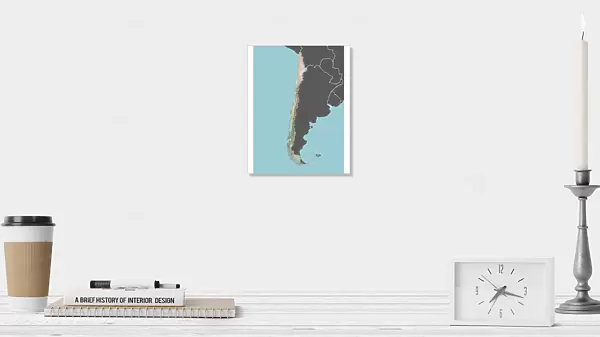
Photographic Print : Chile, Relief Map With Border and Mask


![]()
Photo Prints from Universal Images Group (UIG)
Chile, Relief Map With Border and Mask
Relief map of Chile (with border and mask). This image was compiled from data acquired by landsat 5 & 7 satellites combined with elevation data
Universal Images Group (UIG) manages distribution for many leading specialist agencies worldwide
Media ID 9618739
© Planet Observer/UIG
Andes Atacama Desert Chile Coastline Desert Mountain Mountain Range Relief Map Santiago Shore Snow South America Satellite View
10"x8" (25x20cm) Photo Print
Discover the beauty and complexity of Chile with our stunning Relief Map Print from Media Storehouse, in partnership with Universal Images Group (UIG). This captivating photograph offers a unique perspective of Chile's intricate geography, showcasing its borders and topography in exquisite detail. Compiled from satellite data acquired by Landsat 5 & 7, this high-resolution relief map print also includes elevation data, making it an essential addition for geography enthusiasts, educators, or anyone interested in the wonders of our planet. Bring the mystery and wonder of Chile into your home or office with this beautiful and informative piece of art.
Printed on archival quality paper for unrivalled stable artwork permanence and brilliant colour reproduction with accurate colour rendition and smooth tones. Printed on professional 234gsm Fujifilm Crystal Archive DP II paper. 10x8 for landscape images, 8x10 for portrait images.
Our Photo Prints are in a large range of sizes and are printed on Archival Quality Paper for excellent colour reproduction and longevity. They are ideal for framing (our Framed Prints use these) at a reasonable cost. Alternatives include cheaper Poster Prints and higher quality Fine Art Paper, the choice of which is largely dependant on your budget.
Estimated Image Size (if not cropped) is 18cm x 25.4cm (7.1" x 10")
Estimated Product Size is 20.3cm x 25.4cm (8" x 10")
These are individually made so all sizes are approximate
Artwork printed orientated as per the preview above, with portrait (vertical) orientation to match the source image.
EDITORS COMMENTS
This print showcases the stunning relief map of Chile, providing a unique perspective on the country's diverse landscapes. Compiled from data acquired by Landsat 5 & 7 satellites combined with elevation data, this image beautifully captures the intricate topography of Chile. From towering mountains to vast deserts and picturesque shorelines, this relief map highlights the incredible natural beauty that can be found in South America's longest country. The vertical composition allows viewers to appreciate the full extent of Chile's physical geography, including its majestic mountain ranges and expansive coastline. The photograph also offers a glimpse into Chile's contrasting climate zones, as snow-capped peaks stand in stark contrast to the arid Atacama Desert below. This visual representation not only serves as an excellent tool for cartography enthusiasts but also provides valuable insights into Chilean geography for educational purposes. With no people present in this image, it emphasizes nature's grandeur and invites viewers to immerse themselves in the untouched wilderness of Chile. Whether you are an avid traveler or simply fascinated by geographical wonders, this print is sure to captivate your imagination and transport you directly into the heart of this remarkable South American nation.
MADE IN THE UK
Safe Shipping with 30 Day Money Back Guarantee
FREE PERSONALISATION*
We are proud to offer a range of customisation features including Personalised Captions, Color Filters and Picture Zoom Tools
SECURE PAYMENTS
We happily accept a wide range of payment options so you can pay for the things you need in the way that is most convenient for you
* Options may vary by product and licensing agreement. Zoomed Pictures can be adjusted in the Basket.
