Photographic Print > Animals > Mammals > Didelphidae > Formosa
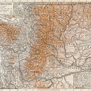
Photographic Print : Geographical map of China


![]()
Photo Prints from Heritage Images
Geographical map of China
Geographical map of China. Plate 63 from The Times Atlas
Heritage Images features heritage image collections
Media ID 15464828
© The Print Collector / Heritage-Images
Cartography Formosa Map Making South China Sea Taiwan
10"x8" (25x20cm) Photo Print
Discover the captivating beauty of China's vast landscapes with our stunning Photographic Prints. This exquisite image, showcasing a Geographical map of China from Heritage Images, will transport you to the heart of this ancient and diverse country. Immerse yourself in its rich history and breathtaking geography as you explore every intricate detail captured in this remarkable piece. Perfect for adding an artistic touch to any space, these prints are sure to ignite your wanderlust and inspire endless conversations about the wonders of China.
Printed on archival quality paper for unrivalled stable artwork permanence and brilliant colour reproduction with accurate colour rendition and smooth tones. Printed on professional 234gsm Fujifilm Crystal Archive DP II paper. 10x8 for landscape images, 8x10 for portrait images.
Our Photo Prints are in a large range of sizes and are printed on Archival Quality Paper for excellent colour reproduction and longevity. They are ideal for framing (our Framed Prints use these) at a reasonable cost. Alternatives include cheaper Poster Prints and higher quality Fine Art Paper, the choice of which is largely dependant on your budget.
Estimated Product Size is 20.3cm x 25.4cm (8" x 10")
These are individually made so all sizes are approximate
Artwork printed orientated as per the preview above, with landscape (horizontal) or portrait (vertical) orientation to match the source image.
FEATURES IN THESE COLLECTIONS
> Animals
> Mammals
> Didelphidae
> Formosa
> Asia
> Taiwan
> Related Images
> Maps and Charts
> Related Images
EDITORS COMMENTS
This print showcases a remarkable piece of cartography, the Geographical map of China. With its vibrant colors and intricate details, this plate from The Times Atlas takes us on an immersive journey through the vast lands of China. Stretching from the coast to the South China Sea, this map beautifully captures the country's geographical features and highlights its diverse regions. The careful craftsmanship evident in this print transports us back in time when mapmaking was both an art form and a scientific endeavor. Every contour line, river bend, and mountain range is meticulously depicted, offering a comprehensive understanding of China's topography. From bustling cities to remote villages nestled amidst breathtaking landscapes, this map invites exploration into every corner of this ancient land. Notably, Taiwan (formerly known as Formosa) also finds its place on this detailed representation. Situated off the southeastern coast of mainland China, it stands as a testament to historical connections between these two territories. As we gaze upon this stunning work by an unknown artist preserved by The Print Collector at Heritage Images, we are reminded of how maps not only serve practical purposes but also evoke curiosity about our world's wonders. This photograph allows us to appreciate the beauty inherent in cartographic masterpieces while honoring their significance as valuable historical artifacts that continue to inspire awe and wonderment today.
MADE IN THE UK
Safe Shipping with 30 Day Money Back Guarantee
FREE PERSONALISATION*
We are proud to offer a range of customisation features including Personalised Captions, Color Filters and Picture Zoom Tools
SECURE PAYMENTS
We happily accept a wide range of payment options so you can pay for the things you need in the way that is most convenient for you
* Options may vary by product and licensing agreement. Zoomed Pictures can be adjusted in the Basket.