Antique Framed Print > Animals > Mammals > Didelphidae > Formosa
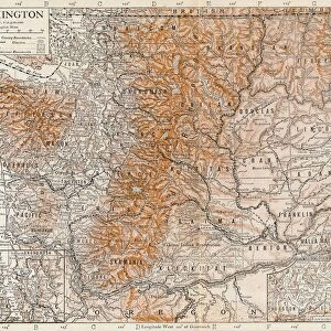
Antique Framed Print : Geographical map of China


![]()
Framed Photos from Heritage Images
Geographical map of China
Geographical map of China. Plate 63 from The Times Atlas
Heritage Images features heritage image collections
Media ID 15464828
© The Print Collector / Heritage-Images
Cartography Formosa Map Making South China Sea Taiwan
14"x12" (36x31cm) Antique Frame
Bevelled wood effect frame, card mounted, 10x8 archival quality photo print. Overall outside dimensions 14x12 inches (36x31cm). Environmentally and ozone friendly, the Polycore® moulding has the look of real wood, is durable and light and easy to hang. Biodegradable and made with non-chlorinated gases (no toxic fumes) it is efficient; producing 100 tons of polystyrene can save 300 tons of trees! Prints are glazed with lightweight, shatterproof, optical clarity acrylic (providing the same general protection from the environment as glass). The back is stapled hardboard with a sawtooth hanger attached. Note: To minimise original artwork cropping, for optimum layout, and to ensure print is secure, the visible print may be marginally smaller
Bevelled Wood Effect Framed and Mounted Prints - Professionally Made and Ready to Hang
Estimated Image Size (if not cropped) is 18.8cm x 24.4cm (7.4" x 9.6")
Estimated Product Size is 31.2cm x 36.3cm (12.3" x 14.3")
These are individually made so all sizes are approximate
Artwork printed orientated as per the preview above, with portrait (vertical) orientation to match the source image.
FEATURES IN THESE COLLECTIONS
> Animals
> Mammals
> Didelphidae
> Formosa
> Asia
> Taiwan
> Related Images
> Maps and Charts
> Related Images
EDITORS COMMENTS
This print showcases a remarkable piece of cartography, the Geographical map of China. With its vibrant colors and intricate details, this plate from The Times Atlas takes us on an immersive journey through the vast lands of China. Stretching from the coast to the South China Sea, this map beautifully captures the country's geographical features and highlights its diverse regions. The careful craftsmanship evident in this print transports us back in time when mapmaking was both an art form and a scientific endeavor. Every contour line, river bend, and mountain range is meticulously depicted, offering a comprehensive understanding of China's topography. From bustling cities to remote villages nestled amidst breathtaking landscapes, this map invites exploration into every corner of this ancient land. Notably, Taiwan (formerly known as Formosa) also finds its place on this detailed representation. Situated off the southeastern coast of mainland China, it stands as a testament to historical connections between these two territories. As we gaze upon this stunning work by an unknown artist preserved by The Print Collector at Heritage Images, we are reminded of how maps not only serve practical purposes but also evoke curiosity about our world's wonders. This photograph allows us to appreciate the beauty inherent in cartographic masterpieces while honoring their significance as valuable historical artifacts that continue to inspire awe and wonderment today.
MADE IN THE UK
Safe Shipping with 30 Day Money Back Guarantee
FREE PERSONALISATION*
We are proud to offer a range of customisation features including Personalised Captions, Color Filters and Picture Zoom Tools
SECURE PAYMENTS
We happily accept a wide range of payment options so you can pay for the things you need in the way that is most convenient for you
* Options may vary by product and licensing agreement. Zoomed Pictures can be adjusted in the Basket.