Photographic Print > Maps and Charts > Abraham Ortelius
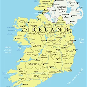
Photographic Print : MAP: IRELAND, 1606. Baptista Boazios map of Ireland. Engraving, published by Abraham Ortelius


![]()
Photo Prints from Granger
MAP: IRELAND, 1606. Baptista Boazios map of Ireland. Engraving, published by Abraham Ortelius
MAP: IRELAND, 1606.
Baptista Boazios map of Ireland. Engraving, published by Abraham Ortelius, 1606
Granger holds millions of images spanning more than 25,000 years of world history, from before the Stone Age to the dawn of the Space Age
Media ID 13637048
1606 Abraham Ireland Irish Sea Latin Ortelius Baptista
10"x8" (25x20cm) Photo Print
Discover the rich history of Ireland with this stunning antique map print from Granger, NYC / The Granger Collection. Dating back to 1606, this exquisite engraving is the work of Baptista Boazios and was published by the renowned cartographer Abraham Ortelius. This vintage map of Ireland, titled "MAP: IRELAND, 1606," is a captivating addition to any home or office, transporting you back in time with its intricate details and historical significance. Bring a piece of the past into your space with this beautiful and authentic work of art from Granger Art on Demand.
Printed on archival quality paper for unrivalled stable artwork permanence and brilliant colour reproduction with accurate colour rendition and smooth tones. Printed on professional 234gsm Fujifilm Crystal Archive DP II paper. 10x8 for landscape images, 8x10 for portrait images.
Our Photo Prints are in a large range of sizes and are printed on Archival Quality Paper for excellent colour reproduction and longevity. They are ideal for framing (our Framed Prints use these) at a reasonable cost. Alternatives include cheaper Poster Prints and higher quality Fine Art Paper, the choice of which is largely dependant on your budget.
Estimated Product Size is 25.4cm x 20.3cm (10" x 8")
These are individually made so all sizes are approximate
Artwork printed orientated as per the preview above, with landscape (horizontal) or portrait (vertical) orientation to match the source image.
EDITORS COMMENTS
MAP: IRELAND, 1606. Baptista Boazios map of Ireland captures the rich history and intricate details of this enchanting island. Published by Abraham Ortelius in 1606, this exquisite engraving showcases the beauty and complexity of Ireland's landscape. The map highlights the Irish Sea that surrounds the country, emphasizing its strategic location and historical significance. With Latin text accompanying the illustration, it offers a glimpse into the scholarly world of cartography during that era. Baptista Boazios' meticulous attention to detail is evident in every line and curve on this print. From the rolling hills to the winding rivers, each element is intricately depicted with precision and artistry. This historic piece transports us back to a time when exploration was at its peak, allowing us to appreciate Ireland's geographical features as seen through an early lens. It serves as a reminder of how maps were not just navigational tools but also works of art that conveyed knowledge and sparked curiosity about distant lands. Granger Art on Demand presents this extraordinary print from their collection - a testament to their commitment to preserving historical artifacts for generations to come. Let this remarkable artwork grace your walls and ignite your imagination with tales from centuries past.
MADE IN THE UK
Safe Shipping with 30 Day Money Back Guarantee
FREE PERSONALISATION*
We are proud to offer a range of customisation features including Personalised Captions, Color Filters and Picture Zoom Tools
SECURE PAYMENTS
We happily accept a wide range of payment options so you can pay for the things you need in the way that is most convenient for you
* Options may vary by product and licensing agreement. Zoomed Pictures can be adjusted in the Basket.