Photographic Print > Historic > Ancient civilizations > Ancient Greece > Greek history
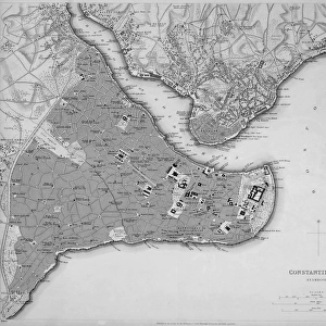
Photographic Print : Map of the Byzantine Empire in the 9th Century


![]()
Photo Prints from Fine Art Storehouse
Map of the Byzantine Empire in the 9th Century
Vintage engraving of a Map of the Byzantine Empire in the 9th Century
Unleash your creativity and transform your space into a visual masterpiece!
duncan1890
Media ID 14549451
© This content is subject to copyright
9th Century Ancient History Asia Minor Asia Pac Byzantine Empire Equipment Greece Mediterranean Sea Middle East Navigational Equipment News Styles Supplies Turkey Byzantine Empire
10"x8" (25x20cm) Photo Print
Introducing the captivating "Map of the Byzantine Empire in the 9th Century" print from our Media Storehouse Fine Art collection. This exquisite vintage engraving, created by the talented artist duncan1890, transports you back in time to the rich and complex history of the Byzantine Empire. With intricate details and meticulous craftsmanship, this print is a stunning addition to any history or art enthusiast's collection. Delve into the intricacies of the Byzantine Empire's vast territories, borders, and historical significance. Embrace the charm of the past with this beautifully preserved piece of history. Order now and bring a touch of ancient wisdom and sophistication to your home or office.
Printed on archival quality paper for unrivalled stable artwork permanence and brilliant colour reproduction with accurate colour rendition and smooth tones. Printed on professional 234gsm Fujifilm Crystal Archive DP II paper. 10x8 for landscape images, 8x10 for portrait images.
Our Photo Prints are in a large range of sizes and are printed on Archival Quality Paper for excellent colour reproduction and longevity. They are ideal for framing (our Framed Prints use these) at a reasonable cost. Alternatives include cheaper Poster Prints and higher quality Fine Art Paper, the choice of which is largely dependant on your budget.
Estimated Product Size is 25.4cm x 20.3cm (10" x 8")
These are individually made so all sizes are approximate
Artwork printed orientated as per the preview above, with landscape (horizontal) or portrait (vertical) orientation to match the source image.
FEATURES IN THESE COLLECTIONS
> Fine Art Storehouse
> Map
> Historical Maps
> Fine Art Storehouse
> Top Sellers - Art Prints
> Animals
> Mammals
> Muridae
> Water Mouse
> Asia
> Related Images
> Asia
> Turkey
> Related Images
> Europe
> Greece
> Related Images
> Europe
> Related Images
> Historic
> Ancient civilizations
> Ancient Greece
> Greek history
> Maps and Charts
> Early Maps
EDITORS COMMENTS
This vintage engraving of a Map of the Byzantine Empire in the 9th Century takes us on a captivating journey back to ancient history. The intricate details and delicate lines etched onto this print transport us to an era filled with grandeur and power. As we gaze upon this black and white masterpiece, we are reminded of the vastness and influence of the Byzantine Empire. Stretching across Asia Minor, Europe, and parts of the Middle East, it was truly an empire that bridged continents. The map showcases not only geographical boundaries but also highlights navigational equipment used during that time. It serves as a window into the past, revealing how seafarers explored uncharted waters using traditional tools such as woodcut engravings. With Greece at its heart and surrounded by the Mediterranean Sea, this illustration captures both beauty and historical significance. Every stroke tells a story - from bustling trade routes connecting Asia Pac to majestic architecture dotting Turkey's landscape. This antique print is more than just a piece of art; it is a testament to human ingenuity and exploration. It reminds us that our present is built upon layers of rich history shaped by empires like Byzantium. Duncan1890 has masterfully preserved this relic from centuries ago, allowing us to appreciate its timeless allure today. Let yourself be transported through time as you admire this remarkable depiction of one of history's greatest empires – The Byzantine Empire in all its glory!
MADE IN THE UK
Safe Shipping with 30 Day Money Back Guarantee
FREE PERSONALISATION*
We are proud to offer a range of customisation features including Personalised Captions, Color Filters and Picture Zoom Tools
SECURE PAYMENTS
We happily accept a wide range of payment options so you can pay for the things you need in the way that is most convenient for you
* Options may vary by product and licensing agreement. Zoomed Pictures can be adjusted in the Basket.