Photographic Print > Fine Art Storehouse > The Magical World of Illustration > Nastasic Images & Illustrations
Photographic Print : Mediterranean sea

![]()
Photo Prints from Fine Art Storehouse
Mediterranean sea
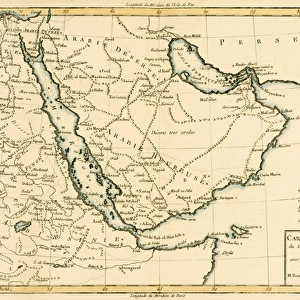
Antique map of Mediterranean Sea
Unleash your creativity and transform your space into a visual masterpiece!
Nastasic
Media ID 13593257
© Nikola Nastasic
17th Century 78271 Cartographer Century Copper Engraving Direction Greece Image Created 17th Century Macro Macrophotography Mediterranean Sea Topography World Map Mediteranean Sea Obsolete
12"x8" (30x20cm) Photo Print
Experience the timeless allure of the Mediterranean with this exquisite photographic print by Nastasic from our Fine Art Storehouse collection. This captivating image of the Mediterranean Sea, artfully framed against the backdrop of an antique map, transports you to the sun-soaked shores and crystal-clear waters of this iconic region. Each print is meticulously crafted using the highest quality materials and techniques, ensuring a stunning, museum-grade presentation that adds elegance and character to any space. Bring a piece of the Mediterranean into your home and let its beauty inspire and delight you every day.
Printed on archival quality paper for unrivalled stable artwork permanence and brilliant colour reproduction with accurate colour rendition and smooth tones. Printed on professional 234gsm Fujifilm Crystal Archive DP II paper. 12x8 for landscape images, 8x12 for portrait images.
Our Photo Prints are in a large range of sizes and are printed on Archival Quality Paper for excellent colour reproduction and longevity. They are ideal for framing (our Framed Prints use these) at a reasonable cost. Alternatives include cheaper Poster Prints and higher quality Fine Art Paper, the choice of which is largely dependant on your budget.
Estimated Image Size (if not cropped) is 30.4cm x 12.7cm (12" x 5")
Estimated Product Size is 30.5cm x 20.3cm (12" x 8")
These are individually made so all sizes are approximate
Artwork printed orientated as per the preview above, with landscape (horizontal) orientation to match the source image.
FEATURES IN THESE COLLECTIONS
> Fine Art Storehouse
> The Magical World of Illustration
> Nastasic Images & Illustrations
> Fine Art Storehouse
> Map
> Historical Maps
> Fine Art Storehouse
> Map
> Italian Maps
EDITORS COMMENTS
This print showcases an antique map of the Mediterranean Sea, taking us back in time to the 17th century. The artistry and precision of cartography are evident in this beautifully engraved image, which offers a glimpse into a bygone era when maps were meticulously crafted by skilled cartographers. The topography of the Mediterranean region is intricately depicted, with Italy, Greece, Europe, and Africa all prominently featured. This copper engraving presents a panoramic view that allows us to appreciate the vastness and interconnectedness of this historic sea. As we delve into the details of this macrophotography masterpiece, we can't help but marvel at how such an old world map still holds relevance today. It serves as a reminder that despite its obsolete nature in terms of navigation technology, it remains an invaluable piece of historical documentation. Nastasic's illustration transports us to a time when direction was sought through these intricate maps rather than GPS devices or smartphones. Its horizontal layout adds to its allure and makes it perfect for display on any wall. Whether you have a passion for history or simply admire fine art, this print will undoubtedly add depth and character to your space. Let yourself be enchanted by the rich heritage captured within this stunning depiction of the Mediterranean Sea.
MADE IN THE UK
Safe Shipping with 30 Day Money Back Guarantee
FREE PERSONALISATION*
We are proud to offer a range of customisation features including Personalised Captions, Color Filters and Picture Zoom Tools
SECURE PAYMENTS
We happily accept a wide range of payment options so you can pay for the things you need in the way that is most convenient for you
* Options may vary by product and licensing agreement. Zoomed Pictures can be adjusted in the Basket.