Photo Mug > Maps and Charts > Related Images
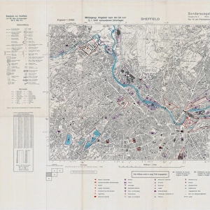
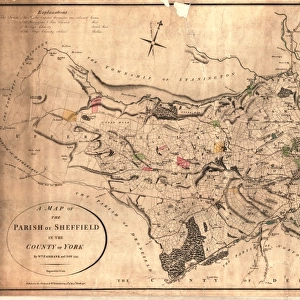
Photo Mug : Sheffield (Central) Planning Scheme; Draft Scheme Map, 1939
 Planning Scheme; Draft Scheme Map, 1939")
 Planning Scheme; Draft Scheme Map, 1939")

![]()
Home Decor from Sheffield City Archives
Sheffield (Central) Planning Scheme; Draft Scheme Map, 1939
Published by Sheffield City Council.Scale 200 feet : 1 inch.Original at Sheffield Local Studies Library:s (39) L
Sheffield City Archives and Local Studies Library has an unrivalled collection of images of Sheffield, England
Media ID 14051584
© Sheffield City Council
Photo Mug
"Add a piece of Sheffield's history to your morning routine with our Media Storehouse Photo Mug. Featuring an iconic image from Sheffield City Archives, this mug showcases the "Sheffield (Central) Planning Scheme; Draft Scheme Map, 1939." Originally published by Sheffield City Council, this detailed map with a scale of 200 feet : 1 inch is a fascinating glimpse into the city's past. Each mug is printed with high-quality, vibrant colors and comes with a smooth, glossy finish. Perfect for a hot beverage, this unique mug makes a great gift for history enthusiasts, locals, or anyone who loves Sheffield's rich heritage. Embrace the past, one sip at a time."
A personalised photo mug blends sentimentality with functionality, making an ideal gift for cherished loved ones, close friends, or valued colleagues. Preview may show both sides of the same mug.
Elevate your coffee or tea experience with our premium white ceramic mug. Its wide, comfortable handle makes drinking easy, and you can rely on it to be both microwave and dishwasher safe. Sold in single units, preview may show both sides of the same mug so you can see how the picture wraps around.
Mug Size is 8cm high x 9.5cm diameter (3.1" x 3.7")
These are individually made so all sizes are approximate
FEATURES IN THESE COLLECTIONS
> Maps and Charts
> Related Images
> Sheffield City Archives
> Maps and Plans
EDITORS COMMENTS
This print showcases the Sheffield (Central) Planning Scheme's Draft Scheme Map from 1939. Published by the esteemed Sheffield City Council, this historical document offers a glimpse into the city's urban planning efforts during that era. The scale of 200 feet to 1 inch provides intricate details and highlights the meticulousness with which this plan was crafted. Preserved at the prestigious Sheffield Local Studies Library, this original piece holds immense value for researchers and history enthusiasts alike. It serves as a testament to the dedication and foresight of city planners who sought to shape Sheffield's future development. The map itself is a visual feast, revealing an intricate network of streets, buildings, parks, and landmarks that formed the foundation of central Sheffield in 1939. Every street corner tells a story; every block represents countless hours of thoughtful consideration. As we gaze upon this remarkable artifact from yesteryears, it transports us back in time – allowing us to appreciate how far our beloved city has come since then. It reminds us that progress is built upon visionary plans like these and encourages us to reflect on how we can continue shaping our urban landscape for future generations
MADE IN THE UK
Safe Shipping with 30 Day Money Back Guarantee
FREE PERSONALISATION*
We are proud to offer a range of customisation features including Personalised Captions, Color Filters and Picture Zoom Tools
SECURE PAYMENTS
We happily accept a wide range of payment options so you can pay for the things you need in the way that is most convenient for you
* Options may vary by product and licensing agreement. Zoomed Pictures can be adjusted in the Basket.