Photo Mug : Map of the Niagara Falls


![]()
Home Decor from Mary Evans Picture Library
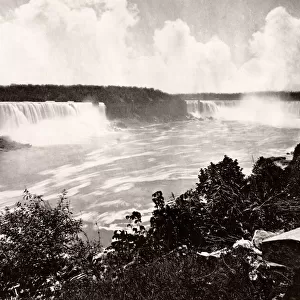
Map of the Niagara Falls
Map of the Niagara Falls. Date: circa 1890
Mary Evans Picture Library makes available wonderful images created for people to enjoy over the centuries
Media ID 14410966
© The Boswell Collection, Bexley Heritage Trust / Mary Evans
Chart Falls Ferry Goat Horseshoe Luna Niagara Plan Railroad
Photo Mug
Bring the majesty of the Niagara Falls into your daily routine with our Media Storehouse Photo Mugs. This beautifully designed mug features a captivating map of the Niagara Falls, dating back to circa 1890, sourced from the extensive collection at Mary Evans Prints Online. Each mug is expertly printed with high-quality, vibrant images that are sure to brighten up your morning coffee or evening tea. A perfect gift for nature lovers, travel enthusiasts, or anyone who appreciates the beauty of the world around us. Embrace the power and allure of the Niagara Falls with every sip.
A personalised photo mug blends sentimentality with functionality, making an ideal gift for cherished loved ones, close friends, or valued colleagues. Preview may show both sides of the same mug.
Elevate your coffee or tea experience with our premium white ceramic mug. Its wide, comfortable handle makes drinking easy, and you can rely on it to be both microwave and dishwasher safe. Sold in single units, preview may show both sides of the same mug so you can see how the picture wraps around.
Mug Size is 8cm high x 9.5cm diameter (3.1" x 3.7")
These are individually made so all sizes are approximate
EDITORS COMMENTS
Step back in time with this map print of Niagara Falls from the late 19th century. Dated circa 1890, this intricately detailed lantern slide offers a bird's eye view of the awe-inspiring natural wonder straddling the border between the United States and Canada. The map highlights the various landmarks and attractions surrounding the falls, including the Horseshoe Falls, Luna Island, Goat Island, and the Central Ferry. The railroad line running along the American side of the Niagara River is also clearly visible. This map provides a glimpse into the past, offering insight into the transportation methods and infrastructure of the time. The presence of the ferry and railroad suggest that tourism was already a significant industry in the late 1800s, drawing visitors from near and far to witness the breathtaking beauty of Niagara Falls. The intricate details of the map, from the winding river to the labeled landmarks, offer a fascinating look into the past. The map's age and historical significance make it a valuable addition to any collection, transporting us back to a time when the wonder of Niagara Falls drew people together from all corners of the world.
MADE IN THE UK
Safe Shipping with 30 Day Money Back Guarantee
FREE PERSONALISATION*
We are proud to offer a range of customisation features including Personalised Captions, Color Filters and Picture Zoom Tools
FREE COLORIZATION SERVICE
You can choose advanced AI Colorization for this picture at no extra charge!
SECURE PAYMENTS
We happily accept a wide range of payment options so you can pay for the things you need in the way that is most convenient for you
* Options may vary by product and licensing agreement. Zoomed Pictures can be adjusted in the Basket.