Fine Art Print : Map of the Niagara Falls


![]()
Fine Art Prints from Mary Evans Picture Library
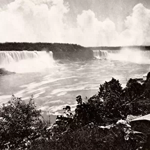
Map of the Niagara Falls
Map of the Niagara Falls. Date: circa 1890
Mary Evans Picture Library makes available wonderful images created for people to enjoy over the centuries
Media ID 14410966
© The Boswell Collection, Bexley Heritage Trust / Mary Evans
Chart Falls Ferry Goat Horseshoe Luna Niagara Plan Railroad
A2 (42x59cm) Fine Art Print
Discover the captivating beauty of the Niagara Falls with our exquisite Fine Art Print from Media Storehouse, in partnership with Mary Evans Prints Online. This stunning, circa 1890 map offers a unique perspective of the iconic waterfalls, inviting you to explore their history and allure. Perfect for enhancing your home or office decor, this high-quality print is a must-have for anyone with an appreciation for the natural world and the rich history of mapmaking. Bring the majesty of Niagara Falls into your space with this beautiful, rights-managed print.
Our Fine Art Prints are printed on 100% acid free, PH neutral paper with archival properties. This printing method is used by museums and art collections to exhibit photographs and art reproductions. Hahnemühle certified studio for digital fine art printing. Printed on 308gsm Photo Rag Paper.
Our fine art prints are high-quality prints made using a paper called Photo Rag. This 100% cotton rag fibre paper is known for its exceptional image sharpness, rich colors, and high level of detail, making it a popular choice for professional photographers and artists. Photo rag paper is our clear recommendation for a fine art paper print. If you can afford to spend more on a higher quality paper, then Photo Rag is our clear recommendation for a fine art paper print.
Estimated Image Size (if not cropped) is 42.1cm x 42cm (16.6" x 16.5")
Estimated Product Size is 59.4cm x 42cm (23.4" x 16.5")
These are individually made so all sizes are approximate
Artwork printed orientated as per the preview above, with landscape (horizontal) orientation to match the source image.
EDITORS COMMENTS
Step back in time with this map print of Niagara Falls from the late 19th century. Dated circa 1890, this intricately detailed lantern slide offers a bird's eye view of the awe-inspiring natural wonder straddling the border between the United States and Canada. The map highlights the various landmarks and attractions surrounding the falls, including the Horseshoe Falls, Luna Island, Goat Island, and the Central Ferry. The railroad line running along the American side of the Niagara River is also clearly visible. This map provides a glimpse into the past, offering insight into the transportation methods and infrastructure of the time. The presence of the ferry and railroad suggest that tourism was already a significant industry in the late 1800s, drawing visitors from near and far to witness the breathtaking beauty of Niagara Falls. The intricate details of the map, from the winding river to the labeled landmarks, offer a fascinating look into the past. The map's age and historical significance make it a valuable addition to any collection, transporting us back to a time when the wonder of Niagara Falls drew people together from all corners of the world.
MADE IN THE UK
Safe Shipping with 30 Day Money Back Guarantee
FREE PERSONALISATION*
We are proud to offer a range of customisation features including Personalised Captions, Color Filters and Picture Zoom Tools
FREE COLORIZATION SERVICE
You can choose advanced AI Colorization for this picture at no extra charge!
SECURE PAYMENTS
We happily accept a wide range of payment options so you can pay for the things you need in the way that is most convenient for you
* Options may vary by product and licensing agreement. Zoomed Pictures can be adjusted in the Basket.