Photo Mug > Europe > France > Canton > Landes
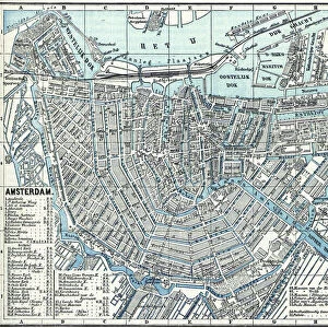
Photo Mug : 1835, S. D. U. K. City Map or Plan of Amsterdam, The Netherlands, topography, cartography


![]()
Home Decor from Liszt Collection
1835, S. D. U. K. City Map or Plan of Amsterdam, The Netherlands, topography, cartography
1835, S.D.U.K. City Map or Plan of Amsterdam, The Netherlands
Liszt Collection of nineteenth-century engravings and images to browse and enjoy
Media ID 14005069
© Artokoloro Quint Lox Limited
1835 The Netherlands Antique Map Latitude Longitude Mappa Mundi Old Antique Plan Old Antique View Ols Antique Map Rare Old Maps Topo
Photo Mug
Step back in time with our Media Storehouse Photo Mug featuring a captivating 1835 S.D.U.K. City Map or Plan of Amsterdam, The Netherlands, from the renowned Liszt Collection. This vintage topography and cartography design showcases intricate details of Amsterdam's historical layout, making each sip an adventure through time. Perfect for history enthusiasts or as a unique gift, this mug not only keeps your beverage warm but also adds a touch of history to your daily routine.
A personalised photo mug blends sentimentality with functionality, making an ideal gift for cherished loved ones, close friends, or valued colleagues. Preview may show both sides of the same mug.
Elevate your coffee or tea experience with our premium white ceramic mug. Its wide, comfortable handle makes drinking easy, and you can rely on it to be both microwave and dishwasher safe. Sold in single units, preview may show both sides of the same mug so you can see how the picture wraps around.
Mug Size is 8cm high x 9.5cm diameter (3.1" x 3.7")
These are individually made so all sizes are approximate
FEATURES IN THESE COLLECTIONS
> Europe
> France
> Canton
> Landes
> Europe
> Netherlands
> Amsterdam
> Europe
> Netherlands
> Maps
> Europe
> Netherlands
> Posters
> Europe
> Netherlands
> Related Images
> Historic
> Space exploration
> Maps and Charts
> Early Maps
> Maps and Charts
> Netherlands
> Maps and Charts
> Related Images
> Maps and Charts
> World
EDITORS COMMENTS
This print showcases a remarkable piece of history - the 1835 S. D. U. K. City Map or Plan of Amsterdam, The Netherlands. Immerse yourself in the rich topography and cartography depicted in this vintage map, which offers a glimpse into the city's past. With its intricate details and precise illustrations, this map serves as both an artistic masterpiece and a valuable geographic resource. As you explore this ancient artifact, you'll be transported to a bygone era when navigation relied on paper maps like these. The grid lines, latitude and longitude markings, and geometric precision demonstrate the meticulous craftsmanship that went into creating such maps during that time. The faded colors and aged appearance add to its charm while reminding us of the passage of time. This decorative piece not only captures historical significance but also evokes a sense of wanderlust for those who appreciate travel and exploration. Whether you're an avid collector or simply fascinated by old maps, this rare gem from Liszt Collection is sure to captivate your imagination. Discover Amsterdam's past through this antique view as it takes you on a journey back in time to experience the city's geography like never before.
MADE IN THE UK
Safe Shipping with 30 Day Money Back Guarantee
FREE PERSONALISATION*
We are proud to offer a range of customisation features including Personalised Captions, Color Filters and Picture Zoom Tools
SECURE PAYMENTS
We happily accept a wide range of payment options so you can pay for the things you need in the way that is most convenient for you
* Options may vary by product and licensing agreement. Zoomed Pictures can be adjusted in the Basket.