Photo Mug > Granger Art on Demand > Maps
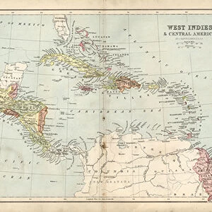
Photo Mug : WEST INDIES MAP, c1890. A German Map of Cuba, Jamaica and Hispaniola, c1890


![]()
Home Decor from Granger
WEST INDIES MAP, c1890. A German Map of Cuba, Jamaica and Hispaniola, c1890
WEST INDIES MAP, c1890.
A German Map of Cuba, Jamaica and Hispaniola, c1890
Granger holds millions of images spanning more than 25,000 years of world history, from before the Stone Age to the dawn of the Space Age
Media ID 12321024
Colonial Costa Rica Cuba Cuban Haiti Hispaniola Island Jamaica Latin America Latin American Mesoamerica New Spain Dominican Republic Honduras
Photo Mug
Add a touch of history to your morning routine with our Media Storehouse Photo Mugs featuring an intriguing vintage map of the West Indies. This captivating design, based on a German map from 1890 by 140_1649248 from Granger Art on Demand, showcases the intricate details of Cuba, Jamaica, and Hispaniola during an era of exploration and discovery. Each mug holds your favorite beverage and makes for a unique conversation starter. Embrace the past while enjoying your daily brew or treat. Perfect for history enthusiasts, travelers, or anyone who appreciates the beauty of antique maps.
A personalised photo mug blends sentimentality with functionality, making an ideal gift for cherished loved ones, close friends, or valued colleagues. Preview may show both sides of the same mug.
Elevate your coffee or tea experience with our premium white ceramic mug. Its wide, comfortable handle makes drinking easy, and you can rely on it to be both microwave and dishwasher safe. Sold in single units, preview may show both sides of the same mug so you can see how the picture wraps around.
Mug Size is 8cm high x 9.5cm diameter (3.1" x 3.7")
These are individually made so all sizes are approximate
EDITORS COMMENTS
This print showcases a remarkable piece of history, the "WEST INDIES MAP, c1890". A German Map of Cuba, Jamaica and Hispaniola takes us back to the late 19th century when colonial powers held sway over these Caribbean islands. The intricate details on this map provide a glimpse into the geopolitical landscape of that era. As we delve into this visual treasure trove, we are transported to an era where Costa Rica, Cuba, Dominican Republic, Haiti, Honduras, and Jamaica were all part of the vibrant tapestry known as Latin America. This map not only serves as a geographical guide but also reflects the influence of Mesoamerica and New Spain in shaping these lands. The artist's attention to detail is evident in every river and island depicted on this print. It truly captures the essence of turn-of-the-century cartography with its meticulous craftsmanship. As we examine each contour line and boundary drawn with precision, we can almost feel ourselves stepping back in time. Whether you are an avid history enthusiast or simply appreciate artistry at its finest, this WEST INDIES MAP from Granger Art on Demand is sure to captivate your imagination. Let it transport you to an era long gone but forever imprinted on our collective memory.
MADE IN THE UK
Safe Shipping with 30 Day Money Back Guarantee
FREE PERSONALISATION*
We are proud to offer a range of customisation features including Personalised Captions, Color Filters and Picture Zoom Tools
SECURE PAYMENTS
We happily accept a wide range of payment options so you can pay for the things you need in the way that is most convenient for you
* Options may vary by product and licensing agreement. Zoomed Pictures can be adjusted in the Basket.