Photo Mug > Historic > Ancient civilizations > Roman Empire > Roman art
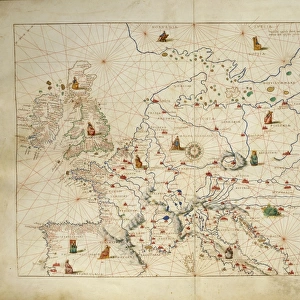
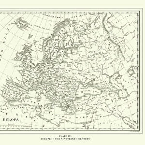
Photo Mug : Map of Europe in late 15th Century


![]()
Home Decor from Fine Art Storehouse
Map of Europe in late 15th Century
Vintage engraving of a Map of Europe in late 15th Century
Unleash your creativity and transform your space into a visual masterpiece!
duncan1890
Media ID 14756500
© This content is subject to copyright
15th Century Empire Equipment Medieval Middle Ages Navigational Equipment News Retro Styles Supplies Holy Roman Empire
Photo Mug
Step back in time with our Media Storehouse Photo Mug featuring a captivating vintage engraving of a Map of Europe from the late 15th Century, sourced from the Fine Art Storehouse by duncan1890. This unique mug showcases intricate details of Europe during an era of exploration and discovery. Perfect for history enthusiasts, travelers, or anyone who appreciates the beauty of vintage maps, this mug is not only a functional drinkware but also a conversation starter. Embrace the past while enjoying your favorite beverage. Cheers to history!
A personalised photo mug blends sentimentality with functionality, making an ideal gift for cherished loved ones, close friends, or valued colleagues. Preview may show both sides of the same mug.
Elevate your coffee or tea experience with our premium white ceramic mug. Its wide, comfortable handle makes drinking easy, and you can rely on it to be both microwave and dishwasher safe. Sold in single units, preview may show both sides of the same mug so you can see how the picture wraps around.
Mug Size is 8cm high x 9.5cm diameter (3.1" x 3.7")
These are individually made so all sizes are approximate
FEATURES IN THESE COLLECTIONS
> Fine Art Storehouse
> Map
> Historical Maps
> Arts
> Art Movements
> Medieval Art
> Arts
> Artists
> R
> Roman Roman
> Europe
> Related Images
> Historic
> Ancient civilizations
> Roman Empire
> Roman art
> Historic
> Historical fashion trends
> Medieval fashion trends
> Maps and Charts
> Related Images
EDITORS COMMENTS
This vintage engraving of a Map of Europe in the late 15th Century takes us on a journey back in time. With its intricate details and black-and-white aesthetic, it offers a glimpse into the cartographic techniques used during this era. The map showcases the vast European continent as it was known centuries ago, with various kingdoms, empires, and territories clearly outlined. As we examine this print closely, we are transported to an age where navigational equipment was rudimentary yet essential for exploration and trade. The woodcut style adds an authentic touch to the illustration, reminding us of the craftsmanship involved in creating such maps during medieval times. The Holy Roman Empire stands out prominently on this map, symbolizing its dominance over much of Central Europe at that period. It serves as a reminder of the complex political landscape that shaped history during those times. This print evokes nostalgia for bygone eras and invites us to reflect on how our understanding of geography has evolved over time. It is not just a piece of art but also a historical artifact that tells stories about ancient civilizations and their interconnectedness. Duncan1890's work captures both the beauty and significance of this antique map, allowing us to appreciate its rich historical context while adding a touch of retro charm to any setting.
MADE IN THE UK
Safe Shipping with 30 Day Money Back Guarantee
FREE PERSONALISATION*
We are proud to offer a range of customisation features including Personalised Captions, Color Filters and Picture Zoom Tools
SECURE PAYMENTS
We happily accept a wide range of payment options so you can pay for the things you need in the way that is most convenient for you
* Options may vary by product and licensing agreement. Zoomed Pictures can be adjusted in the Basket.