Photo Mug > Arts > Artists > W > Frederick de Wit
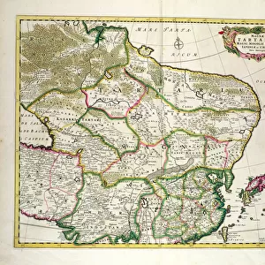
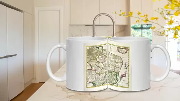
Photo Mug : Map of Mongolia showing part of Russia, Japan and China, c. 1680 (coloured engraving)
")
")

![]()
Home Decor from Fine Art Finder
Map of Mongolia showing part of Russia, Japan and China, c. 1680 (coloured engraving)
BAL42852 Map of Mongolia showing part of Russia, Japan and China, c.1680 (coloured engraving) by Wit, Frederick de (1630-1706); O Shea Gallery, London, UK; Dutch, out of copyright
Media ID 23345850
© Bridgeman Images
Atlas Central Asia Central Asian Geographical Mongolian
Photo Mug
Add a touch of historical charm to your daily routine with our Media Storehouse Photo Mugs. Featuring an intriguing map of Mongolia from the year 1680, this vintage engraving by Wit, Frederick de, showcases the borders of Russia, Japan, and China during an intriguing period in world history. With brilliant colors and intricate detail, this captivating image from Bridgeman Images and Fine Art Finder is sure to make your mug a conversation starter. Embrace the beauty of the past and enjoy your favorite beverage in style.
A personalised photo mug blends sentimentality with functionality, making an ideal gift for cherished loved ones, close friends, or valued colleagues. Preview may show both sides of the same mug.
Elevate your coffee or tea experience with our premium white ceramic mug. Its wide, comfortable handle makes drinking easy, and you can rely on it to be both microwave and dishwasher safe. Sold in single units, preview may show both sides of the same mug so you can see how the picture wraps around.
Mug Size is 8cm high x 9.5cm diameter (3.1" x 3.7")
These are individually made so all sizes are approximate
FEATURES IN THESE COLLECTIONS
> Fine Art Finder
> Artists
> English School
> Fine Art Finder
> Artists
> Frederick de Wit
> Fine Art Finder
> Maps (celestial & Terrestrial)
> Arts
> Artists
> W
> Frederick de Wit
> Asia
> Japan
> Related Images
> Asia
> Mongolia
> Related Images
> Europe
> Russia
> Related Images
EDITORS COMMENTS
This vibrant and intricately detailed coloured engraving, created by Frederick de Wit in 1680, showcases a historical map of Mongolia. The map encompasses not only the vast Mongolian territory but also parts of Russia, Japan, and China. With its rich hues and precise cartographic details, this print offers a glimpse into the geographical landscape of Central Asia during the late 17th century. The Map of Mongolia provides valuable insight into the region's history and cultural significance. Known as Great Tartary or Tartaria at that time, it highlights the extensive reach of Mongolian influence across Central Asia. This engraving serves as an important resource for scholars studying both Mongolian history and global trade routes during this period. Displayed prominently in London's O Shea Gallery, this artwork transports viewers back to a time when maps were meticulously handcrafted works of art. De Wit's mastery is evident in his attention to detail – from mountain ranges to rivers and cities – all carefully etched onto paper with precision. As we admire this exquisite piece from Bridgeman Images' collection, we are reminded of how maps have shaped our understanding of the world throughout centuries. It invites us to explore not only physical geography but also delve deeper into the stories behind these ancient lands - tales that continue to captivate historians and enthusiasts alike.
MADE IN THE UK
Safe Shipping with 30 Day Money Back Guarantee
FREE PERSONALISATION*
We are proud to offer a range of customisation features including Personalised Captions, Color Filters and Picture Zoom Tools
SECURE PAYMENTS
We happily accept a wide range of payment options so you can pay for the things you need in the way that is most convenient for you
* Options may vary by product and licensing agreement. Zoomed Pictures can be adjusted in the Basket.