Mounted Print > Arts > Artists > O > Abraham Ortelius
Mounted Print : Theatrum Orbis Terrarum by Abraham Ortelius (1527-1598)
")
")


![]()
Mounted Prints from Mary Evans Picture Library
Theatrum Orbis Terrarum by Abraham Ortelius (1527-1598)
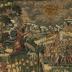
Map of America. Theatrum Orbis Terrarum by Abraham Ortelius (1527-1598). First Edition. Antwerp, 1574
Mary Evans Picture Library makes available wonderful images created for people to enjoy over the centuries
Media ID 14330290
© Thaliastock / Mary Evans
1574 Abraham Americas Antwerp Atlas Barcelona Carthography Cartographic Cartography Catalonia Continent Edition Flanders Flemish Geography Orbis Ortelius Ortels Terrarum Theatrum
10"x8" Mount with 8"x6" Print
Discover the captivating allure of history with our Mounted Photos from the Media Storehouse collection. This exquisite piece showcases the iconic Theatrum Orbis Terrarum map by Abraham Ortelius, a masterpiece of cartography from the 16th century. Depicting the first modern world atlas, this map of America from the first edition, published in Antwerp in 1574, is a testament to the spirit of exploration and discovery. Each Mounted Photo is meticulously printed from high-resolution scans of Mary Evans Prints Online, ensuring the finest detail and vibrant colors. Elevate your home or office décor with this stunning and historically significant addition to your collection.
Printed on 8"x6" paper and suitable for use in a 10"x8" frame (frame not included). Prints are mounted with card both front and back. Featuring a custom cut aperture to match chosen image. Professional 234gsm Fujifilm Crystal Archive DP II paper.
Photo prints supplied in custom cut card mount ready for framing
Estimated Image Size (if not cropped) is 15.2cm x 19.2cm (6" x 7.6")
Estimated Product Size is 20.3cm x 25.4cm (8" x 10")
These are individually made so all sizes are approximate
Artwork printed orientated as per the preview above, with portrait (vertical) orientation to match the source image.
FEATURES IN THESE COLLECTIONS
> Arts
> Artists
> O
> Abraham Ortelius
> Arts
> Artists
> O
> Oceanic Oceanic
> Europe
> Belgium
> Related Images
> Maps and Charts
> Abraham Ortelius
EDITORS COMMENTS
This stunning print is a captivating glimpse into the past, showcasing Abraham Ortelius's seminal work, Theatrum Orbis Terrarum, published in Antwerp in 1574. As the first modern atlas, it revolutionized cartography by bringing together a comprehensive collection of maps into a single volume. This particular map, focusing on America, reflects the incomplete yet intriguing understanding of the New World during the 16th century. Ortelius, a Flemish cartographer, created this masterpiece during the Age of Discovery, a time when European explorers were expanding their horizons and uncovering new lands. The map reveals the known continents of North and South America, with various islands scattered throughout the Atlantic Ocean. The detail is remarkable, with depictions of ships sailing the seas, a Spanish vessel anchored off the coast, and a vibrant, colorful representation of the New World. The map's title, Theatrum Orbis Terrarum, translates to 'Theatre of the World,' reflecting the belief that the world was a stage, and the maps within were the actors. This first edition of the atlas was produced in Antwerp, Flanders, and later found its way to Barcelona, Spain, where it is now housed in a prestigious library. The map is a testament to the spirit of exploration and discovery that characterized the 16th century, offering a fascinating glimpse into the historical context of a time when the world was truly a mystery waiting to be unraveled.
MADE IN THE UK
Safe Shipping with 30 Day Money Back Guarantee
FREE PERSONALISATION*
We are proud to offer a range of customisation features including Personalised Captions, Color Filters and Picture Zoom Tools
SECURE PAYMENTS
We happily accept a wide range of payment options so you can pay for the things you need in the way that is most convenient for you
* Options may vary by product and licensing agreement. Zoomed Pictures can be adjusted in the Basket.