Mounted Print > Europe > United Kingdom > Scotland > Maps
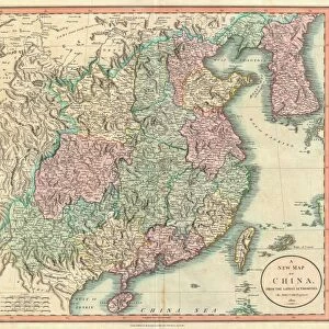
Mounted Print : 1865, Spruner Map of the British Isles, England, Scotland, Ireland, topography, cartography


![]()
Mounted Prints from Liszt Collection
1865, Spruner Map of the British Isles, England, Scotland, Ireland, topography, cartography
1865, Spruner Map of the British Isles, England, Scotland, Ireland
Liszt Collection of nineteenth-century engravings and images to browse and enjoy
Media ID 14006106
© Artokoloro Quint Lox Limited
Ireland Antique Map Latitude Longitude Mappa Mundi Old Antique Plan Old Antique View Ols Antique Map Rare Old Maps Topo
14"x12" Mount with 12"x10" Print
Step back in time with our exquisite Mounted Photos featuring the 1865 Spruner Map of the British Isles. This captivating piece showcases intricate cartography from the Liszt Collection, depicting England, Scotland, and Ireland with stunning topographical detail. Each map is meticulously preserved and mounted on high-quality archival material, ensuring longevity and protection. Elevate your home or office decor with this unique and historically significant piece, transporting you back to the 19th century.
Printed on 12"x10" paper and suitable for use in a 14"x12" frame (frame not included). Prints are mounted with card both front and back. Featuring a custom cut aperture to match chosen image. Professional 234gsm Fujifilm Crystal Archive DP II paper.
Photo prints supplied in custom cut card mount ready for framing
Estimated Image Size (if not cropped) is 25.4cm x 28.1cm (10" x 11.1")
Estimated Product Size is 30.5cm x 35.6cm (12" x 14")
These are individually made so all sizes are approximate
Artwork printed orientated as per the preview above, with portrait (vertical) orientation to match the source image.
FEATURES IN THESE COLLECTIONS
> Europe
> France
> Canton
> Landes
> Europe
> Republic of Ireland
> Maps
> Europe
> United Kingdom
> England
> Maps
> Europe
> United Kingdom
> Scotland
> Maps
> Europe
> United Kingdom
> Scotland
> Posters
> Europe
> United Kingdom
> Scotland
> Related Images
> Historic
> Space exploration
> Maps and Charts
> Early Maps
> Maps and Charts
> Related Images
EDITORS COMMENTS
This print showcases the remarkable 1865 Spruner Map of the British Isles, a true masterpiece in cartography. With intricate topographical details and meticulous accuracy, this map offers a glimpse into the geographical landscape of England, Scotland, and Ireland during that era. The vintage charm of this ancient map is evident through its delicate paper texture and retro aesthetic. Its historical significance cannot be overstated as it provides valuable insights into the world's past. The artistry involved in creating such a detailed illustration is truly commendable. As you explore this enchanting piece, you can almost envision the journeys and discoveries made by explorers who relied on maps like these to navigate uncharted territories. The grid lines representing latitude and longitude add an element of precision to this geographic treasure. This rare old map serves not only as a decorative item but also as a gateway to understanding our planet's history. It invites us to embark on an imaginary voyage back in time when exploration was at its peak. Whether you are an avid collector or simply fascinated by geography, this Spruner Map print from Liszt Collection will undoubtedly captivate your imagination with its rich historical narrative and timeless beauty.
MADE IN THE UK
Safe Shipping with 30 Day Money Back Guarantee
FREE PERSONALISATION*
We are proud to offer a range of customisation features including Personalised Captions, Color Filters and Picture Zoom Tools
SECURE PAYMENTS
We happily accept a wide range of payment options so you can pay for the things you need in the way that is most convenient for you
* Options may vary by product and licensing agreement. Zoomed Pictures can be adjusted in the Basket.