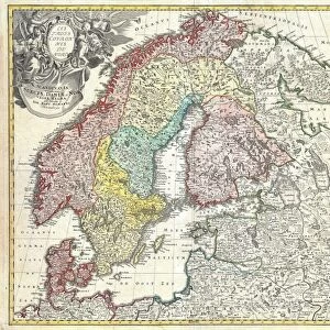
Mounted Print : 1574, Ruscelli Map of Russia, Muscovy and Ukraine, topography, cartography, geography


![]()
Mounted Prints from Liszt Collection
1574, Ruscelli Map of Russia, Muscovy and Ukraine, topography, cartography, geography
1574, Ruscelli Map of Russia, Muscovy and Ukraine
Liszt Collection of nineteenth-century engravings and images to browse and enjoy
Media ID 14004418
© Artokoloro Quint Lox Limited
1574 Antique Map Latitude Longitude Mappa Mundi Old Antique Plan Old Antique View Ols Antique Map Rare Old Maps Topo
10"x8" Mount with 8"x6" Print
Discover history through the lens of exquisite cartography with our Media Storehouse Mounted Photos featuring the 1574 Ruscelli Map of Russia, Muscovy, and Ukraine. This stunning piece, sourced from the esteemed Liszt Collection, showcases intricate topographical details and geographical features of the region during the Renaissance era. Bring a touch of history and intellectual charm to your home or office with this beautifully preserved map, expertly mounted and ready to hang. Explore the rich tapestry of the past while adding a unique and captivating conversation starter to your space.
Printed on 8"x6" paper and suitable for use in a 10"x8" frame (frame not included). Prints are mounted with card both front and back. Featuring a custom cut aperture to match chosen image. Professional 234gsm Fujifilm Crystal Archive DP II paper.
Photo prints supplied in custom cut card mount ready for framing
Estimated Image Size (if not cropped) is 19.9cm x 15.2cm (7.8" x 6")
Estimated Product Size is 25.4cm x 20.3cm (10" x 8")
These are individually made so all sizes are approximate
Artwork printed orientated as per the preview above, with landscape (horizontal) orientation to match the source image.
EDITORS COMMENTS
This print showcases the remarkable 1574 Ruscelli Map of Russia, Muscovy, and Ukraine. A true masterpiece in cartography, this vintage map offers a glimpse into the rich history and topography of these regions. With its intricate details and precise illustrations, it serves as a testament to the artistry and skill of ancient mapmakers. The carefully plotted grid lines reveal latitude and longitude coordinates, allowing for accurate navigation across vast territories. The geometric precision employed in creating this map is truly awe-inspiring. Every contour, river, mountain range, and city is meticulously depicted with artistic flair. As we delve into this historical artifact, we embark on a journey through time—a discovery of lands long past. This rare old map not only provides valuable insights into geographical knowledge from centuries ago but also acts as a window to an era when exploration was at its peak. Printed on aged paper that exudes an air of antiquity, this decorative piece adds a touch of sophistication to any space it graces. Its presence evokes feelings of wonderment as we contemplate the vastness of our world throughout different epochs. Whether you are an avid collector or simply appreciate the beauty found in historical artifacts like maps, this stunning print transports you back in time while simultaneously celebrating the artistry behind early cartography.
MADE IN THE UK
Safe Shipping with 30 Day Money Back Guarantee
FREE PERSONALISATION*
We are proud to offer a range of customisation features including Personalised Captions, Color Filters and Picture Zoom Tools
SECURE PAYMENTS
We happily accept a wide range of payment options so you can pay for the things you need in the way that is most convenient for you
* Options may vary by product and licensing agreement. Zoomed Pictures can be adjusted in the Basket.