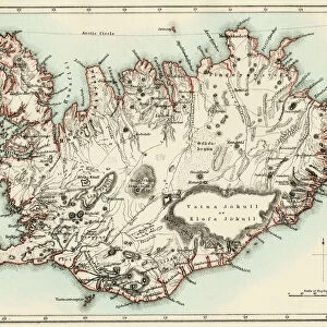
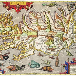
Mounted Print > Europe > Iceland > Maps
Mounted Print : Map of the North Polar Regions


![]()
Mounted Prints from Heritage Images
Map of the North Polar Regions
Map of the North Polar Regions. Map of the Arctic Circle showing Iceland and Scandinavia, northern Russia, Greenland, northern Canada and Alaska. Plate 8 from The Times Atlas
Heritage Images features heritage image collections
Media ID 15464900
© The Print Collector / Heritage-Images
Arctic Circle Canada Cartography Coastline Direction Greenland Map Making North North And Central America North Pole Northern Scandinavia
10"x8" Mount with 8"x6" Print
Discover the enchanting beauty of the North Polar Regions with our exquisite Mounted Photos from Media Storehouse. Featuring an intricately detailed Map of the Arctic Circle, this vintage image from The Times Atlas showcases Iceland and Scandinavia, northern Russia, Greenland, northern Canada, and Alaska. Each Mounted Photo is meticulously printed on premium quality paper and mounted on a sturdy backing, ensuring a long-lasting and elegant presentation. Bring the icy wonders of the North Pole into your home or office with this captivating and conversation-starting piece.
Printed on 8"x6" paper and suitable for use in a 10"x8" frame (frame not included). Prints are mounted with card both front and back. Featuring a custom cut aperture to match chosen image. Professional 234gsm Fujifilm Crystal Archive DP II paper.
Photo prints supplied in custom cut card mount ready for framing
Estimated Image Size (if not cropped) is 19.8cm x 15.2cm (7.8" x 6")
Estimated Product Size is 25.4cm x 20.3cm (10" x 8")
These are individually made so all sizes are approximate
Artwork printed orientated as per the preview above, with landscape (horizontal) orientation to match the source image.
FEATURES IN THESE COLLECTIONS
> Europe
> Iceland
> Related Images
> Europe
> Russia
> Related Images
> Maps and Charts
> Related Images
EDITORS COMMENTS
This print showcases a remarkable piece of cartographic artistry, titled "Map of the North Polar Regions". A true testament to the intricacy and precision of map making, this stunning creation offers an expansive view of the Arctic Circle. The map encompasses Iceland and Scandinavia, northern Russia, Greenland, northern Canada, and Alaska. Plate 8 from The Times Atlas brings forth a vivid display of colors that beautifully delineate coastlines and territories. With great attention to detail, it provides viewers with a comprehensive understanding of geographical locations in these remote regions. As we gaze upon this print, our eyes are drawn to the vastness and grandeur of the North Pole's surroundings. It is as if we can almost feel the crisp arctic air brushing against our skin while standing on these icy terrains. The significance lies not only in its aesthetic appeal but also in its educational value. This visual representation serves as a valuable resource for those seeking knowledge about north-central America's geography or planning expeditions through these uncharted lands. With credit given to The Print Collector - whose name appears alongside unknown contributors - this photograph preserves history by immortalizing an exceptional work that has stood the test of time. Let us appreciate this extraordinary piece for what it truly represents: an amalgamation of artistry and scientific accuracy that continues to captivate curious minds even today.
MADE IN THE UK
Safe Shipping with 30 Day Money Back Guarantee
FREE PERSONALISATION*
We are proud to offer a range of customisation features including Personalised Captions, Color Filters and Picture Zoom Tools
SECURE PAYMENTS
We happily accept a wide range of payment options so you can pay for the things you need in the way that is most convenient for you
* Options may vary by product and licensing agreement. Zoomed Pictures can be adjusted in the Basket.