Mounted Print > Arts > Realistic drawings > Pencil drawings > Black and white artwork
Mounted Print : Antique Netherlands


Resolution may be poor at this size (119 DPI)
![]()
Mounted Prints from Fine Art Storehouse
Antique Netherlands
Netherlands Map, - Antique style. Includes mountains and water bodies. High detail - vector illustration
Unleash your creativity and transform your space into a visual masterpiece!
Media ID 13666511
Cartographer Computer Graphic Computer Graphics East Geographical Border Global Globe Navigational Equipment Intricacy Land National Netherlands North Pencil Drawing Planet Earth Planet Space Sketch South Topography Vector Drawing Art Product White Color
10"x8" Mount with 8"x6" Print
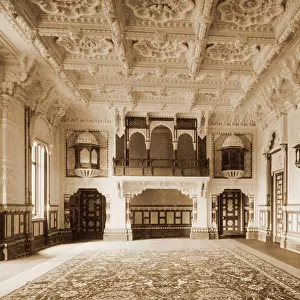
Step back in time with our exquisite Antique Netherlands Mounted Photo from the Media Storehouse Fine Art collection. This stunning piece showcases a detailed, high-definition vector illustration of an antique map of the Netherlands. With intricate depictions of mountains and water bodies, this artwork transports you to a bygone era. Elevate your home or office decor with this beautiful and authentic antique map, a timeless addition to any space.
Printed on 8"x6" paper and suitable for use in a 10"x8" frame (frame not included). Prints are mounted with card both front and back. Featuring a custom cut aperture to match chosen image. Professional 234gsm Fujifilm Crystal Archive DP II paper.
Photo prints supplied in custom cut card mount ready for framing
Estimated Image Size (if not cropped) is 15.2cm x 18.2cm (6" x 7.2")
Estimated Product Size is 20.3cm x 25.4cm (8" x 10")
These are individually made so all sizes are approximate
Artwork printed orientated as per the preview above, with portrait (vertical) orientation to match the source image.
FEATURES IN THESE COLLECTIONS
> Fine Art Storehouse
> Map
> Historical Maps
> Arts
> Realistic drawings
> Pencil drawings
> Black and white artwork
EDITORS COMMENTS
This print takes us on a journey through the past, showcasing an antique map of the Netherlands in exquisite detail. The intricate illustration, created with computer graphics and artistry reminiscent of old-world craftsmanship, transports us to a time when cartographers meticulously sketched every geographical feature by hand. The map encompasses the entire country, from its southern borders to the north, capturing the diverse topography that defines this European nation. Mountains rise majestically in the east while water bodies gracefully meander through its landscapes. Every forest, river, lake, and tree is delicately engraved into this timeless piece of art. As we gaze upon this vintage depiction of the Netherlands' physical geography, we can't help but marvel at how our planet has evolved over centuries. This ancient map serves as a reminder of our connection to history and our place within it. Whether you're an avid traveler or simply appreciate fine design, this antique print will undoubtedly captivate your imagination. Hang it proudly on your wall as a testament to human curiosity and exploration throughout time - a stunning representation of both art and science entwined harmoniously on paper.
MADE IN THE UK
Safe Shipping with 30 Day Money Back Guarantee
FREE PERSONALISATION*
We are proud to offer a range of customisation features including Personalised Captions, Color Filters and Picture Zoom Tools
SECURE PAYMENTS
We happily accept a wide range of payment options so you can pay for the things you need in the way that is most convenient for you
* Options may vary by product and licensing agreement. Zoomed Pictures can be adjusted in the Basket.