Mounted Print > Arts > Artists > B > Guillaume & Jean Bleau
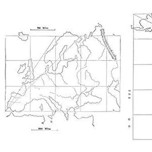
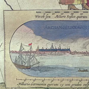
Mounted Print : Territorial holdings of the Dutch West India Company, 1710 (hand coloured print


![]()
Mounted Prints from Fine Art Finder
Territorial holdings of the Dutch West India Company, 1710 (hand coloured print
XOS1765720 Territorial holdings of the Dutch West India Company, 1710 (hand coloured print on vellum) by Bleau, Guillaume & Jean (17th century); 77.3x95.2 cm; New York Public Library, USA; (add.info.: West India Company was incorporated in 1621. This is a late issue (published by Johannes van Kuelen) from the cartographer Willem Janszoon Bleau (1571-1638) and one of the first maps to show the Strait of Le Maire, Argentina, discovered in 1616.
); French, out of copyright
Media ID 12742627
© www.bridgemanimages.com
Amsterdam Argentina Hydrography Nautical Navigation Rhumb Lines Sea Chart Vellum Le Maire Strait
10"x8" Mount with 8"x6" Print
Step back in time with our exquisite Mounted Photos from Media Storehouse, featuring this hand-colored print of the Territorial Holdings of the Dutch West India Company from 1710. This stunning, vintage image, sourced from Bridgeman Images and the New York Public Library, showcases the extensive territories controlled by the Dutch West India Company during the 17th century. Each Mounted Photo is meticulously printed on high-quality archival paper and mounted on a sturdy backing, ensuring a long-lasting and elegant display. Add a touch of history and sophistication to your home or office with this beautiful piece from Media Storehouse.
Printed on 8"x6" paper and suitable for use in a 10"x8" frame (frame not included). Prints are mounted with card both front and back. Featuring a custom cut aperture to match chosen image. Professional 234gsm Fujifilm Crystal Archive DP II paper.
Photo prints supplied in custom cut card mount ready for framing
Estimated Image Size (if not cropped) is 18.9cm x 15.2cm (7.4" x 6")
Estimated Product Size is 25.4cm x 20.3cm (10" x 8")
These are individually made so all sizes are approximate
Artwork printed orientated as per the preview above, with landscape (horizontal) orientation to match the source image.
FEATURES IN THESE COLLECTIONS
> Fine Art Finder
> Artists
> Guillaume & Jean Bleau
> Fine Art Finder
> Maps (celestial & Terrestrial)
> Arts
> Artists
> B
> Guillaume & Jean Bleau
EDITORS COMMENTS
This hand-coloured print on vellum showcases the territorial holdings of the Dutch West India Company in 1710. Measuring an impressive 77.3x95.2 cm, this map is a testament to the cartographic skills of Guillaume and Jean Bleau, prominent figures in 17th-century cartography. Published by Johannes van Kuelen, this late issue map is significant for being one of the first to depict the Strait of Le Maire and Argentina, discovered in 1616. It provides a comprehensive view of America, Africa, and Europe's coastlines with intricate details that highlight hydrography and sea charts. The Dutch West India Company played a crucial role in maritime exploration and trade during its incorporation in 1621. This print offers a glimpse into their vast territorial holdings across various continents. With rhumb lines guiding navigation routes throughout the seas, this map serves as both an artistic masterpiece and a valuable historical document. Its vibrant colours bring life to each landmass and ocean expanse depicted. Housed at the New York Public Library in the United States, this remarkable piece captures not only geographical information but also echoes tales of adventure from centuries past. As you gaze upon it, imagine sailors embarking on perilous journeys through uncharted waters while seeking new opportunities for commerce under the banner of Amsterdam's Netherlands-based company.
MADE IN THE UK
Safe Shipping with 30 Day Money Back Guarantee
FREE PERSONALISATION*
We are proud to offer a range of customisation features including Personalised Captions, Color Filters and Picture Zoom Tools
SECURE PAYMENTS
We happily accept a wide range of payment options so you can pay for the things you need in the way that is most convenient for you
* Options may vary by product and licensing agreement. Zoomed Pictures can be adjusted in the Basket.