Metal Print > Universal Images Group (UIG) > Universal Images Group > Satellite and Aerial > Planet Observer 5
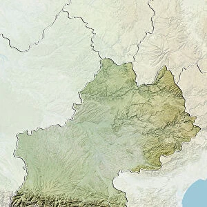
Metal Print : Departement of Ariege, France, Relief Map


![]()
Metal Prints from Universal Images Group (UIG)
Departement of Ariege, France, Relief Map
Relief map of the departement of Ariege, France. It is dominated by the Pyrenees mountains which form the border between France and Spain. This image was compiled from data acquired by LANDSAT 5 & 7 satellites combined with elevation data
Universal Images Group (UIG) manages distribution for many leading specialist agencies worldwide
Media ID 9633595
© Planet Observer
Ariege Geographical Border Midi Pyrenees Mountain Pyrenees Relief Map Satellite View
15"x10" (38x25cm) Metal Print
Discover the breathtaking beauty of the French departement of Ariege with our Media Storehouse Metal Print of the Relief Map from Universal Images Group (UIG). This stunning representation of the region brings the Pyrenees mountains to life, showcasing their majestic peaks and intricate terrain. The metal print's vibrant colors and sleek design add depth and dimension to your space, making it a perfect addition to any home or office. Experience the power of art to transport you to new places with this captivating piece.
Your image is printed photographically and bonded to a 3.5mm thick, Dibond board (black polyethylene sandwiched between two sheets of white coated aluminium). The panel is then sealed with a gloss protective covering. Supplied complete with a wall mount which holds the print 10mm from the wall.
Made with durable metal and luxurious printing techniques, metal prints bring images to life and add a modern touch to any space
Estimated Product Size is 38.1cm x 25.4cm (15" x 10")
These are individually made so all sizes are approximate
Artwork printed orientated as per the preview above, with landscape (horizontal) or portrait (vertical) orientation to match the source image.
EDITORS COMMENTS
This print showcases the breathtaking natural beauty of the Departement of Ariege in France. The relief map reveals a stunning landscape dominated by the majestic Pyrenees mountains, which serve as a picturesque border between France and Spain. Created using data acquired from LANDSAT 5 & 7 satellites combined with elevation information, this image provides an accurate representation of the region's topography. The vibrant colors and intricate details captured in this photograph make it a true work of art. From lush green valleys to rugged peaks, every contour is meticulously depicted, allowing viewers to immerse themselves in the physical geography of Ariege. With no people present, one can fully appreciate the untouched wilderness that stretches across this part of Midi Pyrenees. Cartography enthusiasts will find delight in studying this satellite view as it offers valuable insights into geographical borders and land formations. Whether you are an avid hiker planning your next adventure or simply an admirer of nature's wonders, this horizontal print serves as both a decorative piece and an educational tool. As you gaze upon this remarkable image, let your imagination wander through the vast expanse before you. Feel inspired by the grandeur of these mountains and envision yourself exploring their hidden trails or marveling at their snow-capped peaks during winter months. This print truly encapsulates the essence and allure of Ariege's natural splendor without any commercial connotations attached to it.
MADE IN THE UK
Safe Shipping with 30 Day Money Back Guarantee
FREE PERSONALISATION*
We are proud to offer a range of customisation features including Personalised Captions, Color Filters and Picture Zoom Tools
SECURE PAYMENTS
We happily accept a wide range of payment options so you can pay for the things you need in the way that is most convenient for you
* Options may vary by product and licensing agreement. Zoomed Pictures can be adjusted in the Basket.