Metal Print > Universal Images Group (UIG) > Universal Images Group > Satellite and Aerial > Planet Observer 4
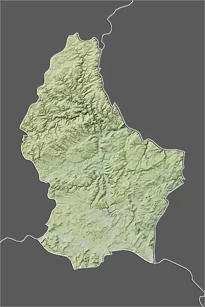
Metal Print : Luxembourg, Relief Map With Border and Mask


![]()
Metal Prints from Universal Images Group (UIG)
Luxembourg, Relief Map With Border and Mask
Relief map of Luxembourg (with border and mask). This image was compiled from data acquired by landsat 5 & 7 satellites combined with elevation data
Universal Images Group (UIG) manages distribution for many leading specialist agencies worldwide
Media ID 9618489
© Planet Observer/UIG
Benelux Luxembourg Relief Map Satellite View
15"x10" (38x25cm) Metal Print
Discover the unique beauty of Luxembourg with our Media Storehouse Metal Print of this stunning Relief Map, expertly crafted from data acquired by Landsat 5 & 7 satellites. This captivating image, featuring the borders and a mask, showcases the undulating terrain of this European country in exquisite detail. Elevation data brings the landscape to life, creating an eye-catching and conversation-starting piece for your home or office. Experience the depth and texture of this metal print, a perfect blend of art and technology.
Your image is printed photographically and bonded to a 3.5mm thick, Dibond board (black polyethylene sandwiched between two sheets of white coated aluminium). The panel is then sealed with a gloss protective covering. Supplied complete with a wall mount which holds the print 10mm from the wall.
Made with durable metal and luxurious printing techniques, metal prints bring images to life and add a modern touch to any space
Estimated Product Size is 25.4cm x 38.1cm (10" x 15")
These are individually made so all sizes are approximate
Artwork printed orientated as per the preview above, with landscape (horizontal) or portrait (vertical) orientation to match the source image.
EDITORS COMMENTS
This print showcases the stunning relief map of Luxembourg, meticulously compiled from data acquired by landsat 5 & 7 satellites combined with elevation data. The image offers a bird's eye view of this enchanting European country, revealing its intricate topography and physical geography in vivid detail. With its vibrant colors and vertical perspective, the photograph truly brings to life the diverse landscape that Luxembourg has to offer. The border and mask surrounding the relief map add an artistic touch, enhancing the visual appeal of this cartographic masterpiece. As you gaze at this print, you can't help but appreciate the immense effort put into creating such a comprehensive representation of Luxembourg's terrain. With no people present in the frame, this image allows us to focus solely on nature's wonders as we explore every contour and valley depicted. It serves as a reminder of how vast and awe-inspiring our planet is. Whether you are a geography enthusiast or simply captivated by beautiful landscapes, this print will undoubtedly make for an intriguing addition to any collection. Its unique blend of satellite imagery and cartography provides both educational value and aesthetic pleasure
MADE IN THE UK
Safe Shipping with 30 Day Money Back Guarantee
FREE PERSONALISATION*
We are proud to offer a range of customisation features including Personalised Captions, Color Filters and Picture Zoom Tools
SECURE PAYMENTS
We happily accept a wide range of payment options so you can pay for the things you need in the way that is most convenient for you
* Options may vary by product and licensing agreement. Zoomed Pictures can be adjusted in the Basket.