Metal Print > Europe > France > Canton > Landes
Metal Print : North America


![]()
Metal Prints from Science Photo Library
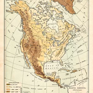
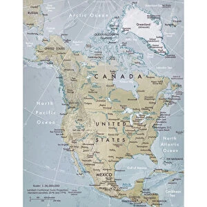
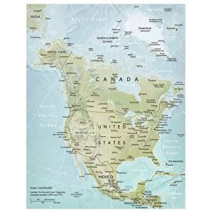
North America
North America, coloured satellite image. North is at top. Vegetation is green, bare earth is brown, water is blue and snow and ice are white. The topography of the land is shown, with mountain ranges dominating the west coast of the continent. Northern Canada, Alaska and the island of Greenland (white, top) extend the Arctic conditions of the polar ice cap southwards. The northern parts of the Atlantic Ocean (right) and Pacific Ocean (left) lie either side of North America. Some of the Caribbean islands are also seen (bottom right)
Science Photo Library features Science and Medical images including photos and illustrations
Media ID 6350555
© PLANETOBSERVER/SCIENCE PHOTO LIBRARY
Arctic Atlantic Canada Caribbean Continent Earth Science From Space Greenland Image Island Islands Land Mexico Mountain Range Mountains Pacific Photos Polar Relief Satellite Image Sciences Snow Topographical Topography Us A Ranges
15"x10" (38x25cm) Metal Print
Discover the breathtaking beauty of North America in a new light with Media Storehouse Metal Prints. This stunning coloured satellite image from Science Photo Library showcases the diverse landscapes of the North American continent. Witness the vibrant greens of lush forests, the expanses of bare earth, the vast expanses of water, and the pristine whiteness of snow and ice. Our high-quality metal prints are not just a decorative addition to your space, they are a conversation starter and a reminder of the wonders our world holds. Order yours today and bring a piece of North America into your home or office.
Your image is printed photographically and bonded to a 3.5mm thick, Dibond board (black polyethylene sandwiched between two sheets of white coated aluminium). The panel is then sealed with a gloss protective covering. Supplied complete with a wall mount which holds the print 10mm from the wall.
Made with durable metal and luxurious printing techniques, metal prints bring images to life and add a modern touch to any space
Estimated Product Size is 38.1cm x 25.4cm (15" x 10")
These are individually made so all sizes are approximate
Artwork printed orientated as per the preview above, with landscape (horizontal) or portrait (vertical) orientation to match the source image.
FEATURES IN THESE COLLECTIONS
> Animals
> Mammals
> Muridae
> Water Mouse
> Arts
> Artists
> O
> Oceanic Oceanic
> Europe
> France
> Canton
> Landes
> Maps and Charts
> Related Images
> North America
> Canada
> Maps
> North America
> Canada
> Related Images
> North America
> Greenland
> Maps
> North America
> Greenland
> Related Images
> North America
> Mexico
> Maps
EDITORS COMMENTS
This print of North America showcases the continent in all its natural beauty. The satellite image, colored to highlight various features, provides a stunning visual representation of this vast landmass. With the north positioned at the top, viewers can easily appreciate the diverse landscapes and geographical elements that define North America. From lush green vegetation to brown bare earth, blue water bodies to white snow and ice, every aspect is vividly captured in this image. Mountain ranges dominate the west coast of the continent, showcasing their majestic presence. Extending southwards from Northern Canada and Alaska is Greenland, covered in pristine white as it extends Arctic conditions towards the polar ice cap. The Atlantic Ocean lies on the right side while the Pacific Ocean stretches on the left side of North America. Additionally, some Caribbean islands are visible at bottom right corner adding a touch of tropical charm to this already mesmerizing scene. This print not only serves as a beautiful piece of art but also offers valuable insights into North America's topography and geography. It allows us to marvel at nature's wonders from space and appreciate how different elements come together harmoniously on our planet. Science Photo Library has once again provided an exceptional visual experience through their expertise in capturing scientific images with artistic finesse.
MADE IN THE UK
Safe Shipping with 30 Day Money Back Guarantee
FREE PERSONALISATION*
We are proud to offer a range of customisation features including Personalised Captions, Color Filters and Picture Zoom Tools
SECURE PAYMENTS
We happily accept a wide range of payment options so you can pay for the things you need in the way that is most convenient for you
* Options may vary by product and licensing agreement. Zoomed Pictures can be adjusted in the Basket.