Metal Print > Historic > Ancient civilizations > Roman Empire > Ancient Rome
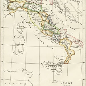
Metal Print : Maps of Italy in ancient times


![]()
Metal Prints from North Wind
Maps of Italy in ancient times
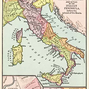
Map of early tribes in Italy (top). of the Roman hills (lower left). and the vicinity of Rome (right) in the time of the Roman Empire.
Printed color lithograph of a 19th-century illustration
North Wind Picture Archives brings history to life with stock images and hand-colored illustrations
Media ID 5878160
© North Wind Picture Archives
Ancient Ancient Civilization Ancient History Ancient Roman Ancient Rome Antiquity Civilization Classical Classical Civilization Europe European Italian Italy Roman Rome Territory Tribe Regions
15"x10" (38x25cm) Metal Print
Discover the rich history of Italy with our exquisite Media Storehouse Metal Prints featuring a collection of ancient maps from North Wind Picture Archives. These captivating prints showcase the early tribes in Italy (top), the Roman hills (lower left), and the vicinity of Rome (right) in the time of the Roman Empire. Each print is a beautiful color lithograph of a 19th-century illustration, meticulously transferred onto high-quality metal sheets for a vibrant, long-lasting display. Bring history to life in your home or office with these stunning and conversation-starting works of art.
Your image is printed photographically and bonded to a 3.5mm thick, Dibond board (black polyethylene sandwiched between two sheets of white coated aluminium). The panel is then sealed with a gloss protective covering. Supplied complete with a wall mount which holds the print 10mm from the wall.
Made with durable metal and luxurious printing techniques, metal prints bring images to life and add a modern touch to any space
Estimated Product Size is 25.4cm x 38.1cm (10" x 15")
These are individually made so all sizes are approximate
Artwork printed orientated as per the preview above, with landscape (horizontal) or portrait (vertical) orientation to match the source image.
FEATURES IN THESE COLLECTIONS
> Arts
> Artists
> R
> Roman Roman
> Europe
> Italy
> Lazio
> Rome
> Historic
> Ancient civilizations
> Roman Empire
> Ancient Rome
> Historic
> Ancient civilizations
> Roman Empire
> Roman art
> Historic
> Ancient civilizations
> Roman Empire
> Historic
> Ancient civilizations
> Maps and Charts
> Early Maps
> Maps and Charts
> Italy
> Maps and Charts
> Related Images
> North Wind Picture Archives
> Ancient history
> North Wind Picture Archives
> Maps
EDITORS COMMENTS
This print showcases the ancient maps of Italy, offering a glimpse into the rich history and civilization that once thrived in this region. The top map depicts the early tribes that inhabited Italy during ancient times, highlighting their territories and boundaries. It serves as a testament to the diverse cultures and societies that coexisted within this land. Moving to the lower left, we encounter a map specifically focusing on the Roman hills. This section provides an intricate view of Rome's surroundings during its glorious days as an empire. It allows us to visualize how these hills played a crucial role in shaping Rome's development and expansion. Lastly, on the right side, we are presented with a detailed depiction of Rome itself during the time of the Roman Empire. This particular map offers insights into its vast territory and showcases its strategic location within Europe. Printed using vibrant colors through lithography techniques from a 19th-century illustration, this vintage artwork exudes classical charm while preserving historical accuracy. Its artistic representation seamlessly combines elements of artistry with factual information about ancient civilizations. Overall, this print is not only visually stunning but also serves as an educational tool for those interested in Italian history, European civilizations, or simply appreciating classical art forms.
MADE IN THE UK
Safe Shipping with 30 Day Money Back Guarantee
FREE PERSONALISATION*
We are proud to offer a range of customisation features including Personalised Captions, Color Filters and Picture Zoom Tools
SECURE PAYMENTS
We happily accept a wide range of payment options so you can pay for the things you need in the way that is most convenient for you
* Options may vary by product and licensing agreement. Zoomed Pictures can be adjusted in the Basket.