Metal Print > Europe > France > Canton > Landes
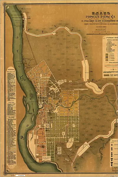
Metal Print : Plan goroda Tomskas prilegai?u?shchei? k nemu zheli?e?znodorozhnoi? vi?e?tv'i?u?, 1898. Creators: M. N. Kononova, I. F. Skulimovskago, Syrtsov S. A


![]()
Metal Prints from Heritage Images
Plan goroda Tomskas prilegai?u?shchei? k nemu zheli?e?znodorozhnoi? vi?e?tv'i?u?, 1898. Creators: M. N. Kononova, I. F. Skulimovskago, Syrtsov S. A
Plan goroda Tomskas prilegai?u?shchei? k nemu zheli?e?znodorozhnoi? vi?e?tv'i?u?, 1898. Scale 1:16, 800; Relief shown by land form drawings. Russian. Shows wards and fire districts. Includes index to points of interest and col. illus. of fire signals
Heritage Images features heritage image collections
Media ID 35129841
© Heritage Art/Heritage Images
Cartographic Cartography Cyrillic District Emergency Services Fire Service Land Legend Legendary Map Making Mapmaking Railroad Ward Meeting Of Frontiers
15"x10" (38x25cm) Metal Print
Discover the rich history of Tomsk, Russia with our stunning Metal Print from Media Storehouse. This exquisite antique map, created by M.N. Kononova, I.F. Skulimovskago, and Syrtsov S.A. in 1898, offers a detailed and intricate representation of the city's layout, including wards and fire districts. The relief is beautifully depicted through land form drawings, providing a unique perspective of Tomsk during that era. Bring history into your home or office with this captivating and high-quality Metal Print from Heritage Images.
Your image is printed photographically and bonded to a 3.5mm thick, Dibond board (black polyethylene sandwiched between two sheets of white coated aluminium). The panel is then sealed with a gloss protective covering. Supplied complete with a wall mount which holds the print 10mm from the wall.
Made with durable metal and luxurious printing techniques, metal prints bring images to life and add a modern touch to any space
Estimated Product Size is 25.4cm x 38.1cm (10" x 15")
These are individually made so all sizes are approximate
Artwork printed orientated as per the preview above, with landscape (horizontal) or portrait (vertical) orientation to match the source image.
FEATURES IN THESE COLLECTIONS
> Arts
> Landscape paintings
> Waterfall and river artworks
> River artworks
> Arts
> Portraits
> Pop art gallery
> Street art portraits
> Europe
> France
> Canton
> Landes
> Europe
> Russia
> Related Images
> Maps and Charts
> Early Maps
> Maps and Charts
> Related Images
EDITORS COMMENTS
This map print, titled "Plan goroda Tomska s prilegaiushchei k nemu zheleznodorozhnoi vietv'iuyu," or "Plan of Tomsk City with its Adjacent Railway Lines," dates back to 1898. The map was created by a team of skilled cartographers, including M.N. Kononova, I.F. Skulimovskago, and Syrtsov S.A. (Кононова М.Н., Скулимовского И.Ф., Сырцова С.А). This intricately detailed map is a testament to the cartographic advancements of the late 19th century, with a scale of 1:16,800 and relief shown through land form drawings. The map provides a comprehensive view of Tomsk City, a historic settlement located in Siberia, Russia. It includes the city's wards and fire districts, making it an essential resource for understanding the urban layout during this period. The map also features an index to points of interest and color illustrations of fire signals, highlighting the importance of emergency services in the city. The map showcases a wealth of geographical features, including rivers, railways, and railroads. The meeting of frontiers between various districts is clearly marked, making it an invaluable resource for understanding the transportation network of the time. The map's text is written in Cyrillic script, adding to its historical and cultural significance. This beautifully illustrated map offers a glimpse into the past, providing insights into the urban planning, transportation, and emergency services of Tomsk City during the late 1800s. The map's intricate details and stunning visuals make it a must-have for anyone interested in Russian history, cartography, or urban development.
MADE IN THE UK
Safe Shipping with 30 Day Money Back Guarantee
FREE PERSONALISATION*
We are proud to offer a range of customisation features including Personalised Captions, Color Filters and Picture Zoom Tools
SECURE PAYMENTS
We happily accept a wide range of payment options so you can pay for the things you need in the way that is most convenient for you
* Options may vary by product and licensing agreement. Zoomed Pictures can be adjusted in the Basket.