Metal Print > Fine Art Storehouse > Map
Metal Print : Antique map of Arabia and adjacent Africa and Persia


![]()
Metal Prints from Fine Art Storehouse
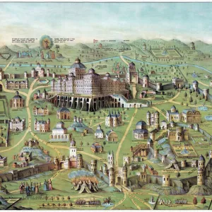
Antique map of Arabia and adjacent Africa and Persia
Unleash your creativity and transform your space into a visual masterpiece!
Hemera Technologies
Media ID 13609519
© Getty Images
Abyssinia Arabia Border Coordinates Direction Document Egypt Ethiopia Geography Horn Horn Of Africa Indian Ocean Israel Jordan Jordan Middle East Latitude Legend Libya Location Longitude Middle East Nile River Nubia Persian Gulf Place Positioning Red Sea Scale Sudan Lybia
15"x10" (38x25cm) Metal Print
Step back in time with our exquisite Antique Map of Arabia and adjacent Africa and Persia from Hemera Technologies, now available as a stunning Metal Print from Media Storehouse. This intricately detailed map, sourced from the Fine Art Storehouse, transports you to a bygone era with its vintage charm and rich historical significance. The metal print's vibrant colors and high-definition clarity bring out the intricacies of the map, making it a beautiful addition to any room. With a sturdy and durable metal construction, this print is not only a feast for the eyes but also a long-lasting investment in art and history. Order yours today and let this captivating piece of cartographic history tell its story in your home or office.
Your image is printed photographically and bonded to a 3.5mm thick, Dibond board (black polyethylene sandwiched between two sheets of white coated aluminium). The panel is then sealed with a gloss protective covering. Supplied complete with a wall mount which holds the print 10mm from the wall.
Made with durable metal and luxurious printing techniques, metal prints bring images to life and add a modern touch to any space
Estimated Product Size is 38.1cm x 25.4cm (15" x 10")
These are individually made so all sizes are approximate
Artwork printed orientated as per the preview above, with landscape (horizontal) or portrait (vertical) orientation to match the source image.
FEATURES IN THESE COLLECTIONS
> Fine Art Storehouse
> Map
> Historical Maps
EDITORS COMMENTS
This print showcases an exquisite antique map of Arabia, adjacent Africa, and Persia. A true testament to the artistry of cartography, this archival piece takes us on a historical journey through time. The intricate details and precision engraving transport us to a bygone era where explorers relied on maps like these for navigation. The map encompasses vast regions including Abyssinia, Egypt, Israel, Jordan, Libya, Nubia, Sudan, and the Horn of Africa. It highlights key geographical features such as the Nile River, Red Sea, Persian Gulf, Indian Ocean and more. With its carefully marked coordinates and legends denoting important locations and borders along with a scale for accurate measurement - it becomes a valuable document that reveals the knowledge of ancient civilizations. Displayed in horizontal format with vibrant colors preserved over time; this vintage masterpiece evokes a sense of wonder about our world's rich history. As we gaze upon it without any human presence captured within its frame or modern distractions surrounding it; we are reminded of the importance placed on physical geography during those times. Photographed by Hemera Technologies for Fine Art Storehouse - this image allows us to appreciate both the beauty and significance behind antique maps while igniting our curiosity about past cultures' understanding of their surroundings.
MADE IN THE UK
Safe Shipping with 30 Day Money Back Guarantee
FREE PERSONALISATION*
We are proud to offer a range of customisation features including Personalised Captions, Color Filters and Picture Zoom Tools
SECURE PAYMENTS
We happily accept a wide range of payment options so you can pay for the things you need in the way that is most convenient for you
* Options may vary by product and licensing agreement. Zoomed Pictures can be adjusted in the Basket.