Metal Print > Arts > Artists > O > Oceanic Oceanic
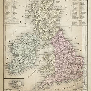
Metal Print : Ancient map of South Africa, lithograph, published in 1876


![]()
Metal Prints from Fine Art Storehouse
Ancient map of South Africa, lithograph, published in 1876
Ancient map of South Africa. Lithograph, published in 1876
Unleash your creativity and transform your space into a visual masterpiece!
Media ID 13666735
© ZU_09
African Culture Atlantic Ocean Coastal Feature Indian Ocean South Africa Southern Africa Topography Obsolete
20"x16" (51x41cm) Metal Print
Step back in time with our exquisite Metal Print of an Ancient Map of South Africa. This stunning lithograph, published in 1876, transports you to a bygone era with intricate details and vibrant colors. The metal print process enhances the image, giving it a three-dimensional effect that brings the historical cartography to life. Perfect for history enthusiasts, world travelers, or anyone who appreciates the beauty of vintage maps, this unique piece is sure to make a statement in any room. Add a touch of history and character to your home or office decor with our Ancient Map of South Africa Metal Print from Fine Art Storehouse.
Your image is printed photographically and bonded to a 3.5mm thick, Dibond board (black polyethylene sandwiched between two sheets of white coated aluminium). The panel is then sealed with a gloss protective covering. Supplied complete with a wall mount which holds the print 10mm from the wall.
Made with durable metal and luxurious printing techniques, metal prints bring images to life and add a modern touch to any space
Estimated Product Size is 50.8cm x 40.6cm (20" x 16")
These are individually made so all sizes are approximate
Artwork printed orientated as per the preview above, with landscape (horizontal) or portrait (vertical) orientation to match the source image.
FEATURES IN THESE COLLECTIONS
> Fine Art Storehouse
> Map
> Historical Maps
> Africa
> Related Images
> Africa
> South Africa
> Maps
> Africa
> South Africa
> Related Images
> Arts
> Artists
> O
> Oceanic Oceanic
> Maps and Charts
> Early Maps
> Maps and Charts
> Related Images
EDITORS COMMENTS
This lithograph from 1876 showcases an ancient map of South Africa, offering a glimpse into the rich cartographic history of the region. The engraved image, now considered antique and obsolete, beautifully captures the topography and coastal features of Southern Africa. As we delve into this piece, we are transported to a bygone era where African culture thrived amidst vast landscapes. The horizontal composition allows us to admire the intricate details etched onto this historical artifact. The coastline is meticulously depicted, tracing the contours of both the Indian Ocean and Atlantic Ocean as they meet with South Africa's shores. This map serves as a testament to how geography has shaped the nation's identity over time. While no people are present in this photograph taken in 2015, it invites us to reflect on our connection with the past and appreciate how far we have come since its creation almost 150 years ago. Displayed proudly at Fine Art Storehouse, this print offers art enthusiasts and history buffs alike an opportunity to explore South Africa through a lens that transcends time. It reminds us of our collective heritage while also celebrating the beauty found within old maps – their ability to tell stories and preserve memories for generations to come.
MADE IN THE UK
Safe Shipping with 30 Day Money Back Guarantee
FREE PERSONALISATION*
We are proud to offer a range of customisation features including Personalised Captions, Color Filters and Picture Zoom Tools
SECURE PAYMENTS
We happily accept a wide range of payment options so you can pay for the things you need in the way that is most convenient for you
* Options may vary by product and licensing agreement. Zoomed Pictures can be adjusted in the Basket.