Home > Africa > Benin > Maps
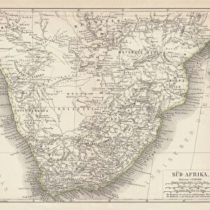
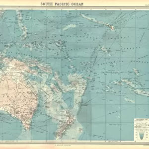
1770, Bonne Map of West Africa, Guinea, the Bight of Benin, Congo, Rigobert Bonne 1727 - 1794

![]()
Wall Art and Photo Gifts from Liszt Collection
1770, Bonne Map of West Africa, Guinea, the Bight of Benin, Congo, Rigobert Bonne 1727 - 1794
1770, Bonne Map of West Africa, Guinea, the Bight of Benin, Congo, Rigobert Bonne 1727 - 1794, one of the most important cartographers of the late 18th century
Liszt Collection of nineteenth-century engravings and images to browse and enjoy
Media ID 14004677
© Artokoloro Quint Lox Limited
1770 Congo Guinea Rigobert Bonne 1727 1794 Rigobert Bonne 1727 – 1794 Rigobert Bonne 17271794 Antique Map Atlas Chart Geographic Latitude Longitude Mappa Mundi Old Antique Plan Old Antique View Old Map Ols Antique Map Rare Old Maps Topo
FEATURES IN THESE COLLECTIONS
> Maps and Charts
> Early Maps
> Maps and Charts
> World
EDITORS COMMENTS
This vintage print showcases the remarkable 1770 Bonne Map of West Africa, created by the renowned cartographer Rigobert Bonne. Known as one of the most influential mapmakers of the late 18th century, Bonne's expertise in topography and geography is evident in this intricate illustration. The map encompasses a vast region, including Guinea, the Bight of Benin, Congo, and other surrounding areas. Its detailed depiction provides valuable insight into the geographical features and land formations of West Africa during that era. With its precise grid lines indicating latitude and longitude, this historic piece served as an essential tool for navigation and exploration at a time when travel was arduous and dangerous. The artistic rendering adds to its allure as it captures both the scientific accuracy required for cartographic purposes and an aesthetic appeal that makes it a decorative masterpiece. As we gaze upon this aged treasure from centuries past, we are transported back to a time when maps were not just navigational aids but also works of art. This antique print serves as a testament to human curiosity about our world's history and geography—a reminder that even in today's modern age with advanced technology at our fingertips, there is still value in appreciating these rare old maps that tell stories of discovery and exploration.
MADE IN THE UK
Safe Shipping with 30 Day Money Back Guarantee
FREE PERSONALISATION*
We are proud to offer a range of customisation features including Personalised Captions, Color Filters and Picture Zoom Tools
SECURE PAYMENTS
We happily accept a wide range of payment options so you can pay for the things you need in the way that is most convenient for you
* Options may vary by product and licensing agreement. Zoomed Pictures can be adjusted in the Basket.