Metal Print > Fine Art Storehouse > Map
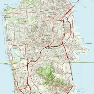
Metal Print : Map of San Francisco


![]()
Metal Prints from Fine Art Storehouse
Map of San Francisco
Antique illustration of a Map of San Francisco
Unleash your creativity and transform your space into a visual masterpiece!
Nastasic
Media ID 13592579
© Nikola Nastasic
1900 American Culture Bay Of Water Bushmen California City Map Colors Dirty Distressed Document Faded Francisco Grid Pacific Ocean Paper Pencil Drawing Photography Themes Pink Color Residential District San Francisco Bay San Francisco California State The Americas Unity Drawing Art Product Obsolete Retro Styled San Francisco Bay Area San Francisco County
15"x10" (38x25cm) Metal Print
Discover the timeless charm of the past with our exquisite Metal Print of the Antique Map of San Francisco by Nastasic, available at Media Storehouse. This fine art piece, sourced from our esteemed Fine Art Storehouse collection, transports you back in time with its intricate details and beautiful illustrations. The vintage map showcases the historic layout of San Francisco, making it a unique and captivating addition to any room. Each Metal Print is meticulously crafted using premium quality materials, ensuring vibrant colors and long-lasting durability. Bring history into your home and add a touch of elegance with this stunning antique map of San Francisco.
Your image is printed photographically and bonded to a 3.5mm thick, Dibond board (black polyethylene sandwiched between two sheets of white coated aluminium). The panel is then sealed with a gloss protective covering. Supplied complete with a wall mount which holds the print 10mm from the wall.
Made with durable metal and luxurious printing techniques, metal prints bring images to life and add a modern touch to any space
Estimated Product Size is 25.4cm x 38.1cm (10" x 15")
These are individually made so all sizes are approximate
Artwork printed orientated as per the preview above, with landscape (horizontal) or portrait (vertical) orientation to match the source image.
FEATURES IN THESE COLLECTIONS
> Fine Art Storehouse
> The Magical World of Illustration
> Nastasic Images & Illustrations
> Fine Art Storehouse
> Map
> Historical Maps
> Fine Art Storehouse
> Map
> USA Maps
EDITORS COMMENTS
This print showcases an antique illustration of a Map of San Francisco, taking us back to the vibrant city's roots. The retro-styled image captures the essence of this iconic destination with its rich history and unique charm. With no people in sight, it allows us to focus solely on the intricate details of this bushmen-engraved masterpiece. The pencil drawing is beautifully engraved, showcasing every street and district within San Francisco County. The faded pink color adds a touch of nostalgia while highlighting the unity and diversity that defines American culture. Despite its obsolete nature, this engraving remains a timeless representation of the city's past. The photograph itself is expertly captured in studio lighting, emphasizing every line and grid on the aged paper surface. Its distressed appearance adds character and authenticity to this historical document. As we gaze upon this vertical image, our eyes are drawn towards San Francisco Bay with its sparkling waters merging seamlessly into the vast Pacific Ocean beyond. Roads wind through residential districts, inviting exploration and discovery. Nastasic has masterfully preserved a piece of San Francisco's heritage through his lens, allowing us to appreciate both its artistic value and significance as a historical artifact. This print serves as a reminder that even amidst modernization, there will always be beauty in embracing our past.
MADE IN THE UK
Safe Shipping with 30 Day Money Back Guarantee
FREE PERSONALISATION*
We are proud to offer a range of customisation features including Personalised Captions, Color Filters and Picture Zoom Tools
SECURE PAYMENTS
We happily accept a wide range of payment options so you can pay for the things you need in the way that is most convenient for you
* Options may vary by product and licensing agreement. Zoomed Pictures can be adjusted in the Basket.