Metal Print > North America > Dominican Republic > Dominican Republic Heritage Sites > Colonial City of Santo Domingo
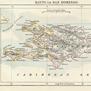
Metal Print : Geography: map of the island of Santo Domingo (Dominican Republic) in the West Indies. Map from an Atlas of Geography of Mendes, 1858. Biblioteca Jose Marti, Havana, Cuba
 in the West Indies. Map from an Atlas of Geography of Mendes, 1858. Biblioteca Jose Marti, Havana, Cuba")


![]()
Metal Prints From Fine Art Finder
Geography: map of the island of Santo Domingo (Dominican Republic) in the West Indies. Map from an Atlas of Geography of Mendes, 1858. Biblioteca Jose Marti, Havana, Cuba
VEN5031333 Geography: map of the island of Santo Domingo (Dominican Republic) in the West Indies. Map from an Atlas of Geography of Mendes, 1858. Biblioteca Jose Marti, Havana, Cuba; (add.info.: Geography: map of the island of Santo Domingo (Dominican Republic) in the West Indies. Map from an Atlas of Geography of Mendes, 1858. Biblioteca Jose Marti, Havana, Cuba); © Marage Photos
Media ID 38164396
© © Marage Photos / Bridgeman Images
Amerique Centrale Amerique Du Nord Caraïbes Caribbean Caribbean Island Carte Geographique Central America Dominium Etats Unis Geographie Saint Domingue Stockravenna Geographical Map
15"x10" (38x25cm) Metal Print
"Explore the rich history of the Dominican Republic with our stunning Metal Print featuring a vintage map of Santo Domingo from 1858. This beautiful piece is part of the Media Storehouse range, showcasing a rare and unique image from Bridgeman Images' Fine Art Finder collection. The intricate details and nostalgic charm of this antique map make it a must-have for any geography enthusiast or lover of historical art. Perfect for adding a touch of elegance to any room, this metal print is sure to spark conversations and inspire curiosity."
Your image is printed photographically and bonded to a 3.5mm thick, Dibond board (black polyethylene sandwiched between two sheets of white coated aluminium). The panel is then sealed with a gloss protective covering. Supplied complete with a wall mount which holds the print 10mm from the wall.
Made with durable metal and luxurious printing techniques, metal prints bring images to life and add a modern touch to any space
Estimated Product Size is 38.1cm x 25.4cm (15" x 10")
These are individually made so all sizes are approximate
Artwork printed orientated as per the preview above, with landscape (horizontal) or portrait (vertical) orientation to match the source image.
FEATURES IN THESE COLLECTIONS
> Maps and Charts
> Early Maps
> Maps and Charts
> Related Images
> North America
> Cuba
> Cuba Heritage Sites
> Old Havana and its Fortification System
> North America
> Cuba
> Havana
> North America
> Cuba
> Maps
> North America
> Cuba
> Related Images
> North America
> Dominican Republic
> Dominican Republic Heritage Sites
> Colonial City of Santo Domingo
> North America
> Dominican Republic
> Maps
> North America
> Dominican Republic
> Related Images
EDITORS COMMENTS
This stunning print captures a detailed map of the island of Santo Domingo (Dominican Republic) in the West Indies, dating back to 1858. The map is from an Atlas of Geography by Mendes and is housed in the Biblioteca Jose Marti in Havana, Cuba.
The intricate engraving showcases the geographical features of the island during the 19th century, providing a glimpse into its past. From its lush landscapes to its coastal shores, every detail is meticulously depicted on this historical map.
As we study this piece, we are transported back in time to an era when cartography was both a science and an art form. The precision and craftsmanship that went into creating this map are truly remarkable, serving as a testament to human ingenuity and curiosity about our world.
Through this image, we not only learn about the geography of Santo Domingo but also gain insight into the broader context of Central America and the Caribbean during that period. It serves as a reminder of how interconnected our world has always been and how maps have played a crucial role in shaping our understanding of it.
Overall, this print is not just a visual representation but also a historical artifact that invites us to explore and appreciate the rich tapestry of our planet's past.
MADE IN THE UK
Safe Shipping with 30 Day Money Back Guarantee
FREE PERSONALISATION*
We are proud to offer a range of customisation features including Personalised Captions, Color Filters and Picture Zoom Tools
SECURE PAYMENTS
We happily accept a wide range of payment options so you can pay for the things you need in the way that is most convenient for you
* Options may vary by product and licensing agreement. Zoomed Pictures can be adjusted in the Basket.