Home > Europe > France > Canton > Val de Marne
Dutch East Indies. Ambon Island, 1612

![]()
Wall Art and Photo Gifts from Mary Evans Picture Library
Dutch East Indies. Ambon Island, 1612
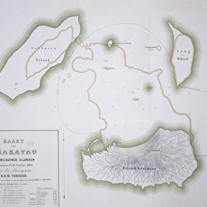
Map of the island of Amboina (Ambon) in the South Moluccas. 1612. Capital of the Dutch East Indies, colonies established by the Dutch East India Company. Engraving. FRANCE. Ό E-DE-FRANCE. VAL-DE-MARNE. Vincennes. Historical Service of the Army
Mary Evans Picture Library makes available wonderful images created for people to enjoy over the centuries
Media ID 14179764
© BeBa/Iberfoto/Mary Evans
1612 Capital Cities Colonialism Colonies Commerce Commerces Commercial Conquest Conquests Craft Crafts Engravings Established Indies Marne Moluccas Settlements Trades Vincennes Xeb25 Amboina Ambon
FEATURES IN THESE COLLECTIONS
> Europe
> France
> Canton
> Marne
> Europe
> France
> Canton
> Val de Marne
> Maps and Charts
> Early Maps
> Maps and Charts
> India
> Services
> Royal Navy
> Transportation
> Ships and Boats
EDITORS COMMENTS
1. Title: "A Glance into the Past: Ambon Island, 1612 - The Dutch East Indies' Early Colonial Beginnings" This map print, hailing from the year 1612, offers a unique glimpse into the early history of the Dutch East Indies, specifically focusing on Ambon Island in the South Moluccas. At this time, Ambon Island served as the capital of the Dutch East Indies, with colonies established by the Dutch East India Company. The intricately detailed engraving, produced in France, showcases the geographical layout of the island, including various cities, urban areas, and bodies of water. The presence of boats and ships in the waters surrounding the island suggests the importance of maritime commerce and naval power during this era. The Dutch East India Company, also known as the Dutch East India Trading Company, played a significant role in the European colonization of the East Indies. The company's influence extended beyond trade, leading to the establishment of settlements and the assertion of Dutch control over various territories. This map serves as a testament to the rich history of the Dutch East Indies and the complex web of political, economic, and cultural interactions that shaped the region during the early modern period. The map's creation in France underscores the global reach and interconnectedness of European powers during this time. As we examine this historical artifact, we are transported back to a time when the Dutch East Indies were just beginning to assert their presence in the region, paving the way for centuries of colonial rule and the intricate tapestry of global history. Keywords: Dutch East Indies, Ambon Island, South Moluccas, Capital, Colonies, Dutch East India Company, Engraving, France, Val-de-Marne, Vincennes, Historical Service of the Army, 1612, Map, Amsterdam, Netherlands, European colonization, Maritime commerce, Naval power, Early modern period.
MADE IN THE UK
Safe Shipping with 30 Day Money Back Guarantee
FREE PERSONALISATION*
We are proud to offer a range of customisation features including Personalised Captions, Color Filters and Picture Zoom Tools
SECURE PAYMENTS
We happily accept a wide range of payment options so you can pay for the things you need in the way that is most convenient for you
* Options may vary by product and licensing agreement. Zoomed Pictures can be adjusted in the Basket.