Home > Arts > Artists > K > Johannes van Keulen
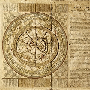
Sea chart of the coasts of England, Scotland and Ireland, Jan Luyken, Johannes van Keulen

![]()
Wall Art and Photo Gifts from Liszt Collection
Sea chart of the coasts of England, Scotland and Ireland, Jan Luyken, Johannes van Keulen
Sea chart of the coasts of England, Scotland and Ireland, Jan Luyken, Johannes van Keulen (I), unknown, 1682 - 1803
Liszt Collection of nineteenth-century engravings and images to browse and enjoy
Media ID 12716651
© Quint Lox Limited
1682 1803 Coasts Compass Compass Roses Cowherd Dish French Miles Herding Herdsman Herdswoman Ireland Jan Luyken Johannes Van Keulen Miles North Roses Sea Chart Sheep Shepherd Shepherdess Sleep Spanish Tree Vignette Chart
FEATURES IN THESE COLLECTIONS
> Animals
> Mammals
> Bovidae
> Sheep
> Arts
> Artists
> K
> Johannes van Keulen
> Arts
> Artists
> L
> Jan Luyken
> Europe
> Republic of Ireland
> Maps
> Europe
> United Kingdom
> England
> Maps
> Europe
> United Kingdom
> Scotland
> Maps
EDITORS COMMENTS
This print showcases a remarkable sea chart of the coasts of England, Scotland, and Ireland. Created by Jan Luyken and Johannes van Keulen in the late 17th century, this map is an exquisite example of their mastery in cartography. The intricate details and precise geographical markings transport us back to a time when exploration was at its peak. The chart not only highlights the coastlines but also provides valuable information about various herding practices prevalent during that era. In one corner, we see a shepherdess tending to her flock of sheep on a peaceful sleeping ground beneath a towering tree. This vignette beautifully captures the pastoral essence of those times. Compass roses elegantly adorn this sea chart, indicating cardinal directions for navigational purposes. It serves as an invaluable tool for sailors venturing into uncharted waters or mapping new territories across Europe. The inclusion of French miles further emphasizes the historical context surrounding this map's creation, showcasing its relevance beyond just English-speaking regions. Its German and Spanish influences are evident through meticulous attention to detail throughout the artwork. Quint Lox's expert photography brings out every nuance present in this stunning piece from the Liszt Collection. As viewers immerse themselves in this image, they can't help but marvel at both its aesthetic beauty and historical significance—a true testament to human curiosity and our eternal quest for knowledge about our world's geography.
MADE IN THE UK
Safe Shipping with 30 Day Money Back Guarantee
FREE PERSONALISATION*
We are proud to offer a range of customisation features including Personalised Captions, Color Filters and Picture Zoom Tools
SECURE PAYMENTS
We happily accept a wide range of payment options so you can pay for the things you need in the way that is most convenient for you
* Options may vary by product and licensing agreement. Zoomed Pictures can be adjusted in the Basket.