Jigsaw Puzzle > Universal Images Group (UIG) > Universal Images Group > Satellite and Aerial > Planet Observer 4
Jigsaw Puzzle : Region of Upper Normandy, France, Relief Map


![]()
Jigsaw Puzzles from Universal Images Group (UIG)
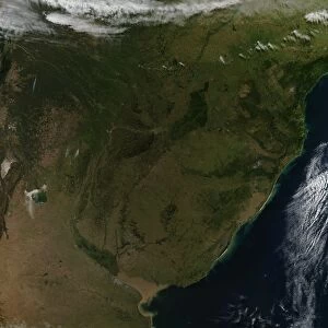
Region of Upper Normandy, France, Relief Map
Relief map of Upper Normandy, France. This image was compiled from data acquired by LANDSAT 5 & 7 satellites combined with elevation data
Universal Images Group (UIG) manages distribution for many leading specialist agencies worldwide
Media ID 9608139
© Planet Observer/UIG
Coastline English Channel Eure Relief Map Rouen Shore Upper Normandy Satellite View Seine Maritime
Jigsaw Puzzle (400 Pieces)
Discover the beauty of Upper Normandy, France with our intricately designed jigsaw puzzle from Media Storehouse. This puzzle features a stunning relief map of the region, meticulously created using data from LANDSAT 5 & 7 satellites and elevation data. Unravel the puzzle pieces to reveal the intricacies of the terrain, bringing the natural wonders of Upper Normandy right to your living room. A perfect activity for puzzle enthusiasts and armchair travelers alike.
400 piece puzzles are custom made in the UK and hand-finished on 100% recycled 1.5 mm millboard. There is a level of repetition in jigsaw shapes with each matching piece away from its pair. The completed puzzle measures 31x47cm and is delivered packaged in an attractive presentation box specially designed to fit most letter box slots
Jigsaw Puzzles are an ideal gift for any occasion
Estimated Product Size is 31.5cm x 47.2cm (12.4" x 18.6")
These are individually made so all sizes are approximate
Artwork printed orientated as per the preview above, with landscape (horizontal) or portrait (vertical) orientation to match the source image.
EDITORS COMMENTS
This stunning print showcases the captivating region of Upper Normandy, France, through a detailed relief map. The image is a compilation of data acquired by LANDSAT 5 & 7 satellites combined with elevation data, resulting in a visually striking representation of the area's topography. The photograph captures the essence of this picturesque region, known for its breathtaking coastline along the English Channel and its charming cities such as Rouen. With its vibrant colors and intricate details, this image offers viewers an immersive experience into the physical geography of Upper Normandy. As you explore this relief map, you can trace the contours of the land and observe how it seamlessly blends with the coastline. From lush green valleys to rolling hills and rugged cliffs overlooking the sea, every aspect of Upper Normandy's diverse landscape is beautifully depicted. This aerial perspective provides a unique satellite view that allows us to appreciate not only the natural beauty but also understand how human settlements have developed within this region over time. The absence of people in this photograph further emphasizes nature's grandeur and invites contemplation. Whether you are an enthusiast in cartography or simply captivated by Europe's scenic wonders, this print will transport you to Upper Normandy from wherever you may be. It serves as both a visual delight and an educational tool for those interested in exploring one of France's most enchanting regions - all captured through Universal Images Group (UIG)'s lens without any commercial intent involved.
MADE IN THE UK
Safe Shipping with 30 Day Money Back Guarantee
FREE PERSONALISATION*
We are proud to offer a range of customisation features including Personalised Captions, Color Filters and Picture Zoom Tools
SECURE PAYMENTS
We happily accept a wide range of payment options so you can pay for the things you need in the way that is most convenient for you
* Options may vary by product and licensing agreement. Zoomed Pictures can be adjusted in the Basket.