Jigsaw Puzzle > Europe > United Kingdom > England > Yorkshire > Stannington
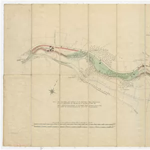
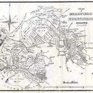
Jigsaw Puzzle : Plan of freehold land for sale at Stannington (Knowl Farm), 1869
, 1869")
, 1869")


![]()
Jigsaw Puzzles from Sheffield City Archives
Plan of freehold land for sale at Stannington (Knowl Farm), 1869
From an original at Sheffield Libraries: y12216
Sheffield City Archives and Local Studies Library has an unrivalled collection of images of Sheffield, England
Media ID 14086791
© Sheffield City Council
Sheffield Stannington Yorkshire
Jigsaw Puzzle (500 Pieces)
Discover the rich history of Sheffield with our captivating Media Storehouse Jigsaw Puzzle featuring a rare Plan of Freehold Land for Sale at Stannington (Knowl Farm) from 1869. This intricately detailed puzzle, sourced from the archives of Sheffield City Archives, offers a unique glimpse into the past. Assemble the pieces to reveal the intricate land parcel layout, and immerse yourself in the history and architecture of this fascinating era. A perfect activity for puzzle enthusiasts, history buffs, or anyone seeking a challenging and rewarding pastime.
500 piece puzzles are custom made in the UK and hand-finished on 100% recycled 1.5 mm millboard. There is a level of repetition in jigsaw shapes with each matching piece away from its pair. The completed puzzle measures 38x50cm and is delivered packaged in an attractive presentation box specially designed to fit most letter box slots
Jigsaw Puzzles are an ideal gift for any occasion
Estimated Product Size is 50.2cm x 38cm (19.8" x 15")
These are individually made so all sizes are approximate
Artwork printed orientated as per the preview above, with landscape (horizontal) or portrait (vertical) orientation to match the source image.
FEATURES IN THESE COLLECTIONS
> Europe
> France
> Canton
> Landes
> Europe
> United Kingdom
> England
> Yorkshire
> Related Images
> Europe
> United Kingdom
> England
> Yorkshire
> Sheffield
> Europe
> United Kingdom
> England
> Yorkshire
> Stannington
> Sheffield City Archives
> Maps and Plans
> Maps of Stannington
EDITORS COMMENTS
This print from the Sheffield City Archives takes us back to the year 1869, offering a glimpse into the past with its detailed "Plan of freehold land for sale at Stannington (Knowl Farm)". The photograph showcases an original document that was carefully preserved by Sheffield Libraries under reference number y12216. The image transports us to the picturesque village of Stannington in Yorkshire, where Knowl Farm stood proudly amidst rolling green fields and charming countryside. The plan reveals intricate details about this piece of freehold land, highlighting its boundaries and features such as Upper Gate Road, Hallfield Lane, and even the Peacock Inn nearby. As we delve into this historical snapshot, it's important to note that our focus here lies solely on capturing a moment frozen in time rather than any commercial implications. Instead, let's appreciate how this photograph allows us to connect with our heritage and gain insight into Sheffield's rich history. Through this visual artifact, we can almost imagine ourselves walking through those very lanes or enjoying a warm meal at the Peacock Inn. It serves as a reminder of how landscapes change over time while also preserving glimpses of what once was. In essence, this print offers an opportunity for reflection and appreciation for both local residents and history enthusiasts alike. It stands as a testament to Sheffield City Archives' dedication towards preserving valuable documents that provide invaluable insights into our collective past.
MADE IN THE UK
Safe Shipping with 30 Day Money Back Guarantee
FREE PERSONALISATION*
We are proud to offer a range of customisation features including Personalised Captions, Color Filters and Picture Zoom Tools
SECURE PAYMENTS
We happily accept a wide range of payment options so you can pay for the things you need in the way that is most convenient for you
* Options may vary by product and licensing agreement. Zoomed Pictures can be adjusted in the Basket.
![A map of Wm. Carrs Farm at Stanington [Stannington], 1747](/sq/716/map-wm-carrs-farm-stanington-stannington-1747-19192400.jpg.webp)


![A survey of a parcel of Land called Platts... [Platts Farm, Ughill], 1728](/sq/716/survey-parcel-land-called-platts-19225923.jpg.webp)
![Maps of Several Parcels of Land proposed to be exchanged, Bradfield, [c. 1750 - 1760]](/sq/716/maps-parcels-land-proposed-exchanged-bradfield-19192402.jpg.webp)