Home > Europe > United Kingdom > England > Yorkshire > Stannington
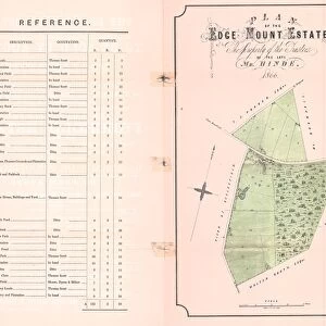
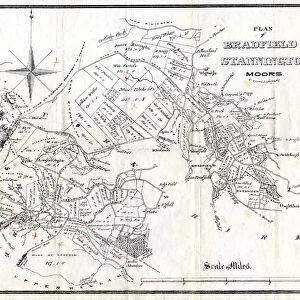
Plan of property situate at Stannington for sale

![]()
Wall Art and Photo Gifts from Sheffield City Archives
Plan of property situate at Stannington for sale
Lot 1 house, buildings, yard, Toft head, The Toft, Toft Bottom, Middle Field and Nether Field or Nether Toft (shows Roman Catholic School).
Lot 2 Towns Field, Occupation Road.
Lot 3 Great Broom Field and Little Broom Field or Meadow, Wood Bank Road.
Original at Sheffield Libraries: y12217
Sheffield City Archives and Local Studies Library has an unrivalled collection of images of Sheffield, England
Media ID 14086793
© Sheffield City Council
Maps Sheffield Stannington Yorkshire
FEATURES IN THESE COLLECTIONS
> Europe
> United Kingdom
> England
> Yorkshire
> Sheffield
> Europe
> United Kingdom
> England
> Yorkshire
> Stannington
> Maps and Charts
> Related Images
> Sheffield City Archives
> Maps and Plans
> Maps of Sheffield
> Sheffield City Archives
> Maps and Plans
> Maps of Stannington
EDITORS COMMENTS
This print from Sheffield City Archives showcases the detailed "Plan of property situate at Stannington for sale". The image captures the essence of a bygone era, offering a glimpse into the rich history and heritage of this Yorkshire town. Lot 1 takes center stage in this visual masterpiece, featuring an exquisite house surrounded by various buildings and a spacious yard. The intricate details highlight every nook and cranny, allowing viewers to immerse themselves in the charm of this property. Toft head, The Toft, Toft Bottom, Middle Field, and Nether Field (or Nether Toft) are also beautifully depicted within Lot 1. Notably, there is even a Roman Catholic School visible on this plot. Moving on to Lot 2, we encounter Towns Field and Occupation Road. This section adds another layer of intrigue to the overall composition as it presents an insight into how urban planning was evolving during that time period. Lastly, Lot 3 encompasses Great Broom Field and Little Broom Field or Meadow along Wood Bank Road. These fields exude tranquility with their lush greenery and open spaces. Preserved meticulously within Sheffield Libraries' archives under reference number y12217, this photograph print serves as a valuable historical artifact. It offers researchers and enthusiasts alike an opportunity to delve deep into Stannington's past while appreciating its architectural beauty
MADE IN THE UK
Safe Shipping with 30 Day Money Back Guarantee
FREE PERSONALISATION*
We are proud to offer a range of customisation features including Personalised Captions, Color Filters and Picture Zoom Tools
SECURE PAYMENTS
We happily accept a wide range of payment options so you can pay for the things you need in the way that is most convenient for you
* Options may vary by product and licensing agreement. Zoomed Pictures can be adjusted in the Basket.
![A map of Wm. Carrs Farm at Stanington [Stannington], 1747](/sq/716/map-wm-carrs-farm-stanington-stannington-1747-19192400.jpg.webp)

![Maps of Several Parcels of Land proposed to be exchanged, Bradfield, [c. 1750 - 1760]](/sq/716/maps-parcels-land-proposed-exchanged-bradfield-19192402.jpg.webp)


![A survey of a parcel of Land called Platts... [Platts Farm, Ughill], 1728](/sq/716/survey-parcel-land-called-platts-19225923.jpg.webp)