Jigsaw Puzzle > Europe > Italy > Lazio > Rome
Jigsaw Puzzle : 16th Century Plan of Rome


![]()
Jigsaw Puzzles from Science Photo Library
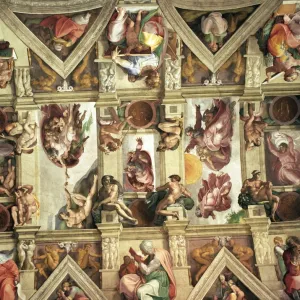
16th Century Plan of Rome
16th century plan of Rome. Details from the map of Latium et Sabina (Southern Lazio), in the Gallery of Maps in the Vatican Museum.The Gallery of Maps holds maps which were commissioned between 1578 and 1580 to show the regions of Italy and territories of the church. The maps are based on the work of Ignazio Danti, a 16th century Italian priest, mathematician, astronomer and cosmographer, and are an important record of 16th century geography
Science Photo Library features Science and Medical images including photos and illustrations
Media ID 6320281
© Sheila Terry
1500s 16th Century Atlas Cartography Earth Science Gallery Of Maps Ignazio Danti Italian Italy Mapping Maps Plan Rome Sciences Sixteenth Century City Plan
Jigsaw Puzzle (500 Pieces)
Discover the rich history of Rome with our exquisite jigsaw puzzles from Media Storehouse. This 16th Century Plan of Rome, taken from the Science Photo Library, offers a fascinating glimpse into the past. Detailed and intricately designed, this puzzle showcases the Map of Latium et Sabina, originally created between 1578 and housed in the Gallery of Maps in the Vatican Museum. Engage in an educational and enjoyable experience as you piece together this historical masterpiece, connecting with the culture and architecture of Rome's illustrious past.
500 piece puzzles are custom made in the UK and hand-finished on 100% recycled 1.5 mm millboard. There is a level of repetition in jigsaw shapes with each matching piece away from its pair. The completed puzzle measures 38x50cm and is delivered packaged in an attractive presentation box specially designed to fit most letter box slots
Jigsaw Puzzles are an ideal gift for any occasion
Estimated Product Size is 50.2cm x 38cm (19.8" x 15")
These are individually made so all sizes are approximate
Artwork printed orientated as per the preview above, with landscape (horizontal) or portrait (vertical) orientation to match the source image.
FEATURES IN THESE COLLECTIONS
> Europe
> Italy
> Lazio
> Related Images
> Europe
> Italy
> Lazio
> Rome
> Europe
> Vatican City
> Maps
> Maps and Charts
> Early Maps
> Maps and Charts
> Italy
> Maps and Charts
> Related Images
EDITORS COMMENTS
This print showcases a remarkable piece of history - the 16th Century Plan of Rome. Taken in the Gallery of Maps within the Vatican Museum, this exquisite map is part of a collection commissioned between 1578 and 1580 to depict various regions of Italy and territories belonging to the church. The mastermind behind these intricate maps was Ignazio Danti, an Italian priest, mathematician, astronomer, and cosmographer. His work not only serves as a testament to his immense talent but also provides us with invaluable insights into the geography of the 16th century. With its meticulous details and stunning illustrations, this map transports us back in time to Renaissance-era Rome. It offers a glimpse into how the city was structured during that period - its streets, landmarks, and architectural marvels all meticulously documented for posterity. As we admire this historical gem captured by Science Photo Library, it becomes evident that cartography truly is an art form. The precision required to create such detailed maps without modern technology is awe-inspiring. This print reminds us of our ancestors' thirst for knowledge about their world and their dedication to preserving it through accurate mapping. Whether you are fascinated by Italian history or have an interest in Earth sciences and cartography, this image will undoubtedly captivate your imagination. Let it transport you on a journey through time as you explore one of humanity's greatest achievements in geographical representation - the 16th Century Plan of Rome.
MADE IN THE UK
Safe Shipping with 30 Day Money Back Guarantee
FREE PERSONALISATION*
We are proud to offer a range of customisation features including Personalised Captions, Color Filters and Picture Zoom Tools
SECURE PAYMENTS
We happily accept a wide range of payment options so you can pay for the things you need in the way that is most convenient for you
* Options may vary by product and licensing agreement. Zoomed Pictures can be adjusted in the Basket.