Jigsaw Puzzle > Europe > United Kingdom > Wales > Maps
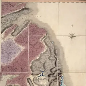
Jigsaw Puzzle : William Smith Geological Map


![]()
Jigsaw Puzzles from Mary Evans Picture Library
William Smith Geological Map
Mary Evans Picture Library makes available wonderful images created for people to enjoy over the centuries
Media ID 8603821
© Mary Evans Picture Library 2015 - https://copyrighthub.org/s0/hub1/creation/maryevans/MaryEvansPictureID/10711270
1769 1839 Geological Geological Map Geologist Geology Great Britain Strata Stratification Treasure William Smith Smith
Jigsaw Puzzle (400 Pieces)
Discover the fascinating world of geology with our William Smith Geological Map jigsaw puzzle from Media Storehouse. This captivating puzzle features an intricately detailed reproduction of the historic map created by the "Father of English Geology," William Smith. Originally published in 1815, this iconic map is now brought to life in puzzle form, offering hours of engaging entertainment for enthusiasts of all ages. Piece together the rich history and intricate details of this groundbreaking geological masterpiece, and bring a piece of scientific history into your home. Perfect for geologists, history buffs, or anyone who appreciates the beauty and complexity of the natural world. The Media Storehouse range of jigsaw puzzles offers a wide variety of intriguing and educational designs, so why not explore our collection and find your next puzzle adventure? (Rights Managed from Mary Evans Prints Online)
400 piece puzzles are custom made in the UK and hand-finished on 100% recycled 1.5 mm millboard. There is a level of repetition in jigsaw shapes with each matching piece away from its pair. The completed puzzle measures 31x47cm and is delivered packaged in an attractive presentation box specially designed to fit most letter box slots
Jigsaw Puzzles are an ideal gift for any occasion
Estimated Product Size is 31.5cm x 47.2cm (12.4" x 18.6")
These are individually made so all sizes are approximate
Artwork printed orientated as per the preview above, with landscape (horizontal) or portrait (vertical) orientation to match the source image.
FEATURES IN THESE COLLECTIONS
> Arts
> Artists
> D
> William Day
> Arts
> Artists
> S
> Mary Smith
> Europe
> Related Images
> Europe
> United Kingdom
> England
> Maps
> Europe
> United Kingdom
> England
> Posters
> Europe
> United Kingdom
> England
> Related Images
> Europe
> United Kingdom
> Wales
> Maps
> Europe
> United Kingdom
> Wales
> Posters
> Europe
> United Kingdom
> Wales
> Related Images
> Maps and Charts
> Geological Map
> Maps and Charts
> Popular Maps
> Popular Themes
> Maps and Charts
EDITORS COMMENTS
1. Title: "William Smith's Groundbreaking Geological Map of Great Britain: A Treasured Legacy of Stratigraphic Discoveries" This image showcases a rare and historic print of the "Geological Map of England and Wales," created by the renowned English geologist William Smith between 1769 and 1839. Smith is considered a pioneer in the field of geology for his significant contributions to the understanding of rock strata and their relationships, a concept known as stratigraphy. The map, which covers much of Great Britain, is a testament to Smith's meticulous observations and dedication to unraveling the mysteries of the Earth's geological past. By carefully studying the various rock formations and their sequences, Smith was able to create one of the first comprehensive geological maps, providing an essential foundation for future geological research. The map's intricate details reveal the complex stratification of rocks across the landscape, with different colors representing various geological formations. This visual representation of the geological history of the region remains a valuable resource for scientists, students, and enthusiasts alike. Smith's groundbreaking work not only revolutionized the field of geology but also paved the way for the development of the geological survey and the modern science of geology. This print serves as a reminder of the rich history of geological discoveries and the enduring legacy of William Smith's pioneering work. The image captures the essence of a daytime scene, with the map spread out on a table outside, inviting exploration and study. The map's intricate details and the natural light filtering through the window create a sense of discovery and wonder, making this a truly treasured piece of European scientific history.
MADE IN THE UK
Safe Shipping with 30 Day Money Back Guarantee
FREE PERSONALISATION*
We are proud to offer a range of customisation features including Personalised Captions, Color Filters and Picture Zoom Tools
SECURE PAYMENTS
We happily accept a wide range of payment options so you can pay for the things you need in the way that is most convenient for you
* Options may vary by product and licensing agreement. Zoomed Pictures can be adjusted in the Basket.