Jigsaw Puzzle > Africa > Libya > Maps
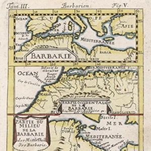
Jigsaw Puzzle : Map of Northern Africa


![]()
Jigsaw Puzzles from Mary Evans Picture Library
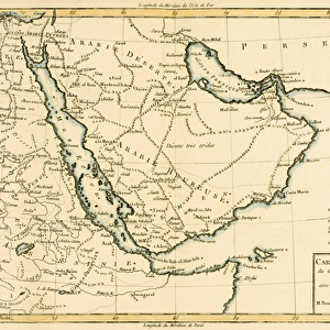
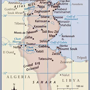
Map of Northern Africa
Map of Northern Africa. Date: 1807
Mary Evans Picture Library makes available wonderful images created for people to enjoy over the centuries
Media ID 11575335
© Mary Evans / Grenville Collins Postcard Collection
1807 Algeria Balearic Chart Coastline Libya Libyan Maps Mauretania Mediterranean Tunisia Numidia
Jigsaw Puzzle (500 Pieces)
Discover the rich history and cultural wonders of Northern Africa with our exquisite jigsaw puzzle from Media Storehouse. This captivating puzzle, featuring an 1807 map of Northern Africa from Mary Evans Prints Online, invites you on a journey of exploration and learning. With intricate details and vibrant colors, this puzzle is not only a fun and engaging activity for all ages, but also a beautiful addition to any room. Piece together the intricacies of the map, and immerse yourself in the fascinating history of this iconic region. Experience the joy of completion and the satisfaction of bringing a piece of history to life with our Media Storehouse jigsaw puzzle.
500 piece puzzles are custom made in the UK and hand-finished on 100% recycled 1.5 mm millboard. There is a level of repetition in jigsaw shapes with each matching piece away from its pair. The completed puzzle measures 38x50cm and is delivered packaged in an attractive presentation box specially designed to fit most letter box slots
Jigsaw Puzzles are an ideal gift for any occasion
Estimated Product Size is 50.2cm x 38cm (19.8" x 15")
These are individually made so all sizes are approximate
Artwork printed orientated as per the preview above, with landscape (horizontal) or portrait (vertical) orientation to match the source image.
FEATURES IN THESE COLLECTIONS
> Africa
> Algeria
> Related Images
> Africa
> Libya
> Related Images
> Africa
> Related Images
> Africa
> Tunisia
> Related Images
> Europe
> Spain
> Related Images
EDITORS COMMENTS
This intriguing map, dated 1807, offers a captivating glimpse into the historical geography of Northern Africa. The map, titled "Carte de l'Afrique Septentrionale," was published during a time of significant exploration and shifting political alliances in the region. The map's detailed depiction of the coastline reveals the Mediterranean Sea's role as a vital maritime highway, connecting Europe to Africa and the Middle East. The Balearic Islands off the eastern coast of Spain are clearly marked, as are the Libyan and Tunisian coasts to the west. The interior of the map is filled with intriguing place names, many of which are now familiar, yet others, such as Numidia and Mauretania, evoke a sense of history long past. These ancient kingdoms once dominated the region, and their legacies continue to shape the cultural and historical landscape of Northern Africa. The map also highlights the complex political landscape of the time. The Libyan territories are depicted as being under the control of the Ottoman Empire, while Algeria and Tunisia are shown as independent states. The Spanish territories in the westernmost part of the map, including the Canary Islands, are also clearly marked. The map's key provides valuable information about the various features depicted, including the locations of major cities, rivers, and mountains. The inclusion of a scale and meridians further underscores the map's scientific accuracy and importance as a historical document. This map offers a fascinating window into the past, revealing the rich history and complex geography of Northern Africa during a time of exploration and change. Its intricate details and historical significance make it an invaluable resource for scholars, historians, and anyone interested in the history of this fascinating region.
MADE IN THE UK
Safe Shipping with 30 Day Money Back Guarantee
FREE PERSONALISATION*
We are proud to offer a range of customisation features including Personalised Captions, Color Filters and Picture Zoom Tools
SECURE PAYMENTS
We happily accept a wide range of payment options so you can pay for the things you need in the way that is most convenient for you
* Options may vary by product and licensing agreement. Zoomed Pictures can be adjusted in the Basket.