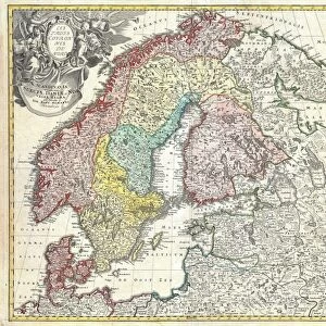
Jigsaw Puzzle : 1747, La Feuille Map of Scandinavia, Sweden, Norway, Finland, topography, cartography


![]()
Jigsaw Puzzles from Liszt Collection
1747, La Feuille Map of Scandinavia, Sweden, Norway, Finland, topography, cartography
1747, La Feuille Map of Scandinavia, Sweden, Norway, Finland
Liszt Collection of nineteenth-century engravings and images to browse and enjoy
Media ID 14004588
© Artokoloro Quint Lox Limited
1747 Finland Norway Sweden Antique Map Latitude Longitude Mappa Mundi Old Antique Plan Old Antique View Ols Antique Map Rare Old Maps Topo
Jigsaw Puzzle (400 Pieces)
Discover the wonders of historical cartography with our Media Storehouse Jigsaw Puzzle featuring the 1747, La Feuille Map of Scandinavia. This intricately detailed puzzle, sourced from the esteemed Liszt Collection, invites you to explore the topography of Sweden, Norway, and Finland as they were depicted over 270 years ago. Immerse yourself in the fascinating world of cartography and geography while engaging your mind and enhancing your problem-solving skills. With each piece carefully cut and meticulously designed, this puzzle promises a captivating and rewarding experience for puzzle enthusiasts and history buffs alike.
400 piece puzzles are custom made in the UK and hand-finished on 100% recycled 1.5 mm millboard. There is a level of repetition in jigsaw shapes with each matching piece away from its pair. The completed puzzle measures 31x47cm and is delivered packaged in an attractive presentation box specially designed to fit most letter box slots
Jigsaw Puzzles are an ideal gift for any occasion
Estimated Product Size is 47.2cm x 31.5cm (18.6" x 12.4")
These are individually made so all sizes are approximate
Artwork printed orientated as per the preview above, with landscape (horizontal) or portrait (vertical) orientation to match the source image.
EDITORS COMMENTS
This print showcases the intricate details of the "1747, La Feuille Map of Scandinavia, Sweden, Norway, Finland". A true masterpiece in cartography and topography, this vintage map takes us on a journey through time and space. The carefully drawn lines and grids represent latitude and longitude, allowing us to navigate through these enchanting lands. The artistic illustration beautifully captures the geographic features of Scandinavia with its mountains, rivers, forests, and coastlines. It is a testament to the skillful craftsmanship of historical mapmakers who meticulously documented our world before modern technology. As we gaze upon this ancient artifact from history's treasure trove, we are transported back to an era when exploration and discovery were at their peak. This old antique view provides a glimpse into how people perceived their surroundings centuries ago. With its decorative elements and aged appearance on paper, this rare old map adds a touch of elegance to any space it graces. Its presence evokes a sense of wonderment about our planet's past while reminding us that even in today's digital age, there is still value in preserving tangible pieces of our heritage. Whether you are an avid collector or simply appreciate the beauty found within historical artifacts like maps, this stunning print offers both aesthetic pleasure and educational insight into Scandinavia's rich geographical history.
MADE IN THE UK
Safe Shipping with 30 Day Money Back Guarantee
FREE PERSONALISATION*
We are proud to offer a range of customisation features including Personalised Captions, Color Filters and Picture Zoom Tools
SECURE PAYMENTS
We happily accept a wide range of payment options so you can pay for the things you need in the way that is most convenient for you
* Options may vary by product and licensing agreement. Zoomed Pictures can be adjusted in the Basket.