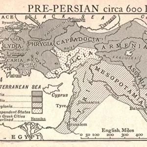
Jigsaw Puzzle : 1720, Weigel Map of the Caucuses including Armenia, Georgia, and Azerbaijan, topography


![]()
Jigsaw Puzzles from Liszt Collection
1720, Weigel Map of the Caucuses including Armenia, Georgia, and Azerbaijan, topography
1720, Weigel Map of the Caucuses including Armenia, Georgia, and Azerbaijan
Liszt Collection of nineteenth-century engravings and images to browse and enjoy
Media ID 14004497
© Artokoloro Quint Lox Limited
1720 Georgia Antique Map Latitude Longitude Mappa Mundi Old Antique Plan Old Antique View Ols Antique Map Rare Old Maps Topo
Jigsaw Puzzle (500 Pieces)
Discover the rich history and geography of the Caucasus region with our stunning 1720 Weigel Map of Armenia, Georgia, and Azerbaijan jigsaw puzzle from Media Storehouse. This intricately detailed puzzle, featuring the topography from the renowned Liszt Collection, transports you back in time to explore the intricacies of this historic map. With vivid colors and precise piece shapes, this puzzle promises an engaging and rewarding puzzle-solving experience for enthusiasts of all ages. Delve into the captivating history and beauty of the Caucasus with the 1720 Weigel Map puzzle - a perfect addition to any home or office.
500 piece puzzles are custom made in the UK and hand-finished on 100% recycled 1.5 mm millboard. There is a level of repetition in jigsaw shapes with each matching piece away from its pair. The completed puzzle measures 38x50cm and is delivered packaged in an attractive presentation box specially designed to fit most letter box slots
Jigsaw Puzzles are an ideal gift for any occasion
Estimated Product Size is 50.2cm x 38cm (19.8" x 15")
These are individually made so all sizes are approximate
Artwork printed orientated as per the preview above, with landscape (horizontal) or portrait (vertical) orientation to match the source image.
EDITORS COMMENTS
This print showcases the exquisite 1720 Weigel Map of the Caucuses, offering a fascinating glimpse into the historical geography of Armenia, Georgia, and Azerbaijan. The intricate topography depicted on this map transports us back in time to an era when cartography was both an art form and a scientific endeavor. With its meticulous attention to detail, this vintage map provides a wealth of information about the landforms and geographic features that define this region. From mountain ranges to rivers, valleys to plateaus, every contour is meticulously illustrated with precision and skill. As we explore this ancient relic from history, we are reminded of the importance of navigation and discovery in shaping our understanding of the world. This map served as a vital tool for explorers seeking new territories or traders charting their routes through unfamiliar lands. The aged appearance adds an air of authenticity to this historic piece. Its yellowed paper texture evokes nostalgia for bygone eras while reminding us that knowledge is timeless. This decorative artwork not only serves as a window into our past but also stands as a testament to human curiosity and ingenuity. Whether you are an avid collector or simply fascinated by history's mysteries, this rare old map offers endless possibilities for exploration within its carefully drawn lines. Let your imagination soar as you embark on a journey through time with this remarkable piece from Liszt Collection's archives.
MADE IN THE UK
Safe Shipping with 30 Day Money Back Guarantee
FREE PERSONALISATION*
We are proud to offer a range of customisation features including Personalised Captions, Color Filters and Picture Zoom Tools
SECURE PAYMENTS
We happily accept a wide range of payment options so you can pay for the things you need in the way that is most convenient for you
* Options may vary by product and licensing agreement. Zoomed Pictures can be adjusted in the Basket.