Jigsaw Puzzle > North America > United States of America > New York > New York > Maps
Jigsaw Puzzle : Palestine map 1875


![]()
Jigsaw Puzzles from Fine Art Storehouse
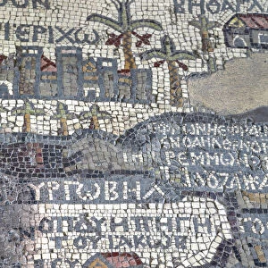
Palestine map 1875
The Independent Course Comprehensive Geography by James Monteith, A.S. Barnes & Co, New York & Chicago 1875
Unleash your creativity and transform your space into a visual masterpiece!
THEPALMER
Media ID 13612199
© This content is subject to copyright
Globe Navigational Equipment Palestine Paper Drawing Art Product Palestinian Territories
Jigsaw Puzzle (400 Pieces)
Discover the captivating history of the Middle East with our exquisite Palestine Map 1875 jigsaw puzzle from Media Storehouse's Fine Art Storehouse collection. This intricately detailed puzzle, based on the independent course comprehensive geography book by James Monteith, published by A.S. Barnes & Co, New York & Chicago in 1875, showcases an antique map of Palestine. Travel back in time and piece together this stunning representation of the region's rich history. Immerse yourself in the intricacies of this historical puzzle, perfect for history enthusiasts, geography buffs, and anyone seeking a challenging and educational pastime. Bring the past to life in the present with this captivating addition to your collection.
400 piece puzzles are custom made in the UK and hand-finished on 100% recycled 1.5 mm millboard. There is a level of repetition in jigsaw shapes with each matching piece away from its pair. The completed puzzle measures 31x47cm and is delivered packaged in an attractive presentation box specially designed to fit most letter box slots
Jigsaw Puzzles are an ideal gift for any occasion
Estimated Product Size is 31.5cm x 47.2cm (12.4" x 18.6")
These are individually made so all sizes are approximate
Artwork printed orientated as per the preview above, with landscape (horizontal) or portrait (vertical) orientation to match the source image.
FEATURES IN THESE COLLECTIONS
> Fine Art Storehouse
> The Magical World of Illustration
> Palmer Illustrated Collection
> Fine Art Storehouse
> Map
> Historical Maps
> Asia
> Palestine
> Related Images
> Maps and Charts
> Related Images
> North America
> United States of America
> Maps
> North America
> United States of America
> New York
> New York
> Maps
> North America
> United States of America
> New York
> Related Images
EDITORS COMMENTS
This print showcases a historical gem, the "Palestine map 1875" from James Monteith's renowned book, "The Independent Course Comprehensive Geography". Published by A. S. Barnes & Co in New York and Chicago back in 1875, this exquisite piece of cartography takes us on a journey through time. The image captures the essence of an era when maps were meticulously hand-drawn and engraved with utmost precision. Displayed vertically against a backdrop of nature's beauty, this old paper print exudes an air of authenticity that transports us to the past. Its intricate details are brought to life through delicate etching and engraving techniques, showcasing the mastery of artistry during that period. As we gaze upon this antique masterpiece, our eyes are drawn to Palestine's geographical features depicted with great accuracy. This illustration serves as a valuable resource for understanding the physical geography of Palestinian territories at that time. "The Palestine map 1875" is not just an ordinary drawing; it represents a significant milestone in cartographic history. It reminds us how far we have come in terms of navigational equipment and mapping technologies since then. Courtesy of THEPALMER from Fine Art Storehouse, this print allows us to appreciate both its artistic value and historical significance. It serves as a reminder that art can transcend time and space while providing insight into our world's rich heritage.
MADE IN THE UK
Safe Shipping with 30 Day Money Back Guarantee
FREE PERSONALISATION*
We are proud to offer a range of customisation features including Personalised Captions, Color Filters and Picture Zoom Tools
SECURE PAYMENTS
We happily accept a wide range of payment options so you can pay for the things you need in the way that is most convenient for you
* Options may vary by product and licensing agreement. Zoomed Pictures can be adjusted in the Basket.