Antique Framed Print > North America > United States of America > New York > New York > Maps
Antique Framed Print : Palestine map 1875


![]()
Framed Photos from Fine Art Storehouse
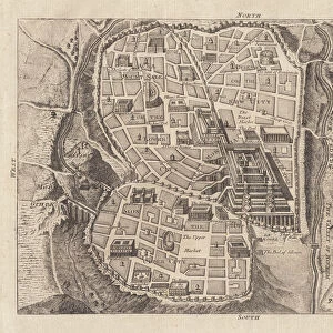
Palestine map 1875
The Independent Course Comprehensive Geography by James Monteith, A.S. Barnes & Co, New York & Chicago 1875
Unleash your creativity and transform your space into a visual masterpiece!
THEPALMER
Media ID 13612199
© This content is subject to copyright
Globe Navigational Equipment Palestine Paper Drawing Art Product Palestinian Territories
21"x16" (54x41cm) Antique Frame
Bevelled wood effect frame, card mounted, 15x10 archival quality photo print. Overall outside dimensions 21x16 inches (54x41cm). Environmentally and ozone friendly, Polycore® moulding has the look of real wood, is durable and light and easy to hang. Biodegradable and made with non-chlorinated gases (no toxic fumes) it is efficient; producing 100 tons of polystyrene can save 300 tons of trees! Prints are glazed with lightweight, shatterproof, optical clarity acrylic (providing the same general protection from the environment as glass). The back is stapled hardboard with a sawtooth hanger attached. Note: To minimise original artwork cropping, for optimum layout, and to ensure print is secure, the visible print may be marginally smaller
Bevelled Wood Effect Framed and Mounted Prints - Professionally Made and Ready to Hang
Estimated Image Size (if not cropped) is 25cm x 37.1cm (9.8" x 14.6")
Estimated Product Size is 41.4cm x 54cm (16.3" x 21.3")
These are individually made so all sizes are approximate
Artwork printed orientated as per the preview above, with portrait (vertical) orientation to match the source image.
FEATURES IN THESE COLLECTIONS
> Asia
> Palestine
> Related Images
> Maps and Charts
> Related Images
> North America
> United States of America
> Maps
> North America
> United States of America
> New York
> New York
> Maps
> North America
> United States of America
> New York
> Related Images
> Fine Art Storehouse
> The Magical World of Illustration
> Palmer Illustrated Collection
> Fine Art Storehouse
> Map
> Historical Maps
EDITORS COMMENTS
This print showcases a historical gem, the "Palestine map 1875" from James Monteith's renowned book, "The Independent Course Comprehensive Geography". Published by A. S. Barnes & Co in New York and Chicago back in 1875, this exquisite piece of cartography takes us on a journey through time. The image captures the essence of an era when maps were meticulously hand-drawn and engraved with utmost precision. Displayed vertically against a backdrop of nature's beauty, this old paper print exudes an air of authenticity that transports us to the past. Its intricate details are brought to life through delicate etching and engraving techniques, showcasing the mastery of artistry during that period. As we gaze upon this antique masterpiece, our eyes are drawn to Palestine's geographical features depicted with great accuracy. This illustration serves as a valuable resource for understanding the physical geography of Palestinian territories at that time. "The Palestine map 1875" is not just an ordinary drawing; it represents a significant milestone in cartographic history. It reminds us how far we have come in terms of navigational equipment and mapping technologies since then. Courtesy of THEPALMER from Fine Art Storehouse, this print allows us to appreciate both its artistic value and historical significance. It serves as a reminder that art can transcend time and space while providing insight into our world's rich heritage.
MADE IN THE UK
Safe Shipping with 30 Day Money Back Guarantee
FREE PERSONALISATION*
We are proud to offer a range of customisation features including Personalised Captions, Color Filters and Picture Zoom Tools
SECURE PAYMENTS
We happily accept a wide range of payment options so you can pay for the things you need in the way that is most convenient for you
* Options may vary by product and licensing agreement. Zoomed Pictures can be adjusted in the Basket.