Jigsaw Puzzle > Europe > Italy > Lazio > Rome
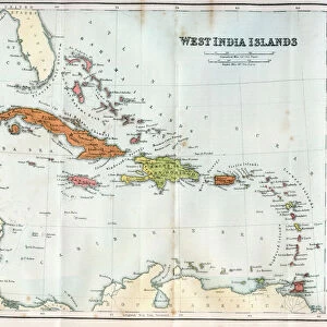
Jigsaw Puzzle : Geography map: representation of the island of Cuba, Jamaica, Bahamas, South Florida and Yucatan in the Gulf of Mexico from an Atlas made by the Italian cartographer Antonio Francesco Lucini (born 1605), about 1661 Biblioteca Angelica, Rome
, about 1661 Biblioteca Angelica, Rome")
, about 1661 Biblioteca Angelica, Rome")


![]()
Jigsaw Puzzles From Fine Art Finder
Geography map: representation of the island of Cuba, Jamaica, Bahamas, South Florida and Yucatan in the Gulf of Mexico from an Atlas made by the Italian cartographer Antonio Francesco Lucini (born 1605), about 1661 Biblioteca Angelica, Rome
VEN5030476 Geography map: representation of the island of Cuba, Jamaica, Bahamas, South Florida and Yucatan in the Gulf of Mexico from an Atlas made by the Italian cartographer Antonio Francesco Lucini (born 1605), about 1661 Biblioteca Angelica, Rome; (add.info.: Geography map: representation of the island of Cuba, Jamaica, Bahamas, South Florida and Yucatan in the Gulf of Mexico from an Atlas made by the Italian cartographer Antonio Francesco Lucini (born 1605), about 1661 Biblioteca Angelica, Rome); © Marage Photos
Media ID 38426186
© © Marage Photos / Bridgeman Images
17eme Siecle Amerique Centrale Amerique Du Nord Carte Geographique Central America Cuba Cuba Cubain Cubaine Cubains Cubaines Cuban Etats Unis Geographie Jamaica Jamaican Mexicans Mexico Mexican Mexique Stockravenna 17th Centuries Etats Unis Etats Unis Usa United States Geographical Map
Jigsaw Puzzle (400 Pieces)
Embark on a journey through time and geography with our captivating jigsaw puzzle featuring an antique map of Cuba, Jamaica, Bahamas, South Florida, and Yucatan. Perfect for history buffs and puzzle enthusiasts alike.
400 piece puzzles are custom made in the UK and hand-finished on 100% recycled 1.5 mm millboard. There is a level of repetition in jigsaw shapes with each matching piece away from its pair. The completed puzzle measures 31x47cm and is delivered packaged in an attractive presentation box specially designed to fit most letter box slots
Jigsaw Puzzles are an ideal gift for any occasion
Estimated Product Size is 47.2cm x 31.5cm (18.6" x 12.4")
These are individually made so all sizes are approximate
Artwork printed orientated as per the preview above, with landscape (horizontal) or portrait (vertical) orientation to match the source image.
FEATURES IN THESE COLLECTIONS
> Fine Art Finder
> Artists
> Pasquier (workshop of) Grenier
> Europe
> Italy
> Lazio
> Rome
> Maps and Charts
> Early Maps
> Maps and Charts
> Italy
> Maps and Charts
> Related Images
> North America
> The Bahamas
> Maps
> North America
> The Bahamas
> Related Images
> North America
> Cuba
> Maps
> North America
> Cuba
> Related Images
EDITORS COMMENTS
This stunning geography map, created by Italian cartographer Antonio Francesco Lucini in approximately 1661, provides a detailed representation of the island of Cuba, Jamaica, Bahamas, South Florida, and Yucatan in the Gulf of Mexico. The intricate details captured in this print showcase the skill and precision of Lucini's work during the 17th century.
The map offers a glimpse into the geographical landscape of Central America and North America during this time period, highlighting key locations such as Cuba and Jamaica. The inclusion of South Florida and Yucatan further expands on the scope of this historical document, providing valuable insight into the region's topography.
Displayed in an Atlas housed at Biblioteca Angelica in Rome, this piece serves as a testament to both artistic talent and scientific knowledge. The engravings featured on this map demonstrate a level of craftsmanship that was highly esteemed during the 17th century.
As we admire this piece from Marage Photos via Fine Art Finder, we are transported back in time to an era where exploration and discovery were paramount. Through Lucini's meticulous mapping techniques, viewers can appreciate the beauty and complexity of these interconnected landmasses within the Gulf of Mexico.
MADE IN THE UK
Safe Shipping with 30 Day Money Back Guarantee
FREE PERSONALISATION*
We are proud to offer a range of customisation features including Personalised Captions, Color Filters and Picture Zoom Tools
SECURE PAYMENTS
We happily accept a wide range of payment options so you can pay for the things you need in the way that is most convenient for you
* Options may vary by product and licensing agreement. Zoomed Pictures can be adjusted in the Basket.