Home > Europe > Montenegro > Maps
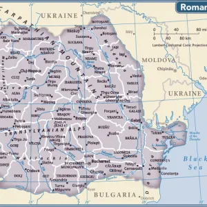
Map To Illustrate the Eastern Battle Fronts, 1919. Creator: George Philip & Son Ltd

![]()
Wall Art and Photo Gifts from Heritage Images
Map To Illustrate the Eastern Battle Fronts, 1919. Creator: George Philip & Son Ltd
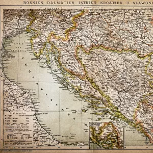
Map To Illustrate the Eastern Battle Fronts, 1919. Map showing areas of eastern Europe and the Balkans which saw fighting during the First World War, 1914-1919, including Italy, Austria-Hungary, Albania, Montenegro, Greece, Serbia, Bulgaria, Romania, and parts of Russia and Turkey. From " The History of the Great European War: its causes and effects", Vol. V, by W. Stanley Macbean Knight. [Caxton Pulishing Company, Limited, London, 1919]
Heritage Images features heritage image collections
Media ID 19047833
© The Print Collector/Heritage Images
Adriatic Aegean Albania And Son Ltd Austria Hungary Austro Hungarian Balkans Black Sea Bulgaria Caxton Publishing Company Caxton Pulishing Company Caxton Pulishing Company Lim Caxton Pulishing Company Limited Caxton Pulishing Company Ltd Eastern Front George Philip And Son George Philip And Son Ltd Knight Limited Montenegro Philip Romania Serbia Stanley Macbean Stanley Macbean Knight Turkey Turkish W Stanley Macbean W Stanley Macbean Knight William Stanley Macbean William Stanley Macbean Knight 1st World War
FEATURES IN THESE COLLECTIONS
> Asia
> Turkey
> Related Images
> Europe
> Montenegro
> Maps
EDITORS COMMENTS
This print titled "Map To Illustrate the Eastern Battle Fronts, 1919" takes us back to a significant moment in history. Created by George Philip & Son Ltd, this map showcases the areas of eastern Europe and the Balkans that witnessed intense fighting during World War I from 1914 to 1919. The vibrant colors bring life to this historical document, highlighting countries such as Italy, Austria-Hungary, Albania, Montenegro, Greece, Serbia, Bulgaria, Romania, Russia, and Turkey. The intricate details on the map provide a comprehensive understanding of the geographical features and locations of these nations. As we gaze upon this piece of artistry from "The History of the Great European War: its causes and effects" written by W. Stanley Macbean Knight in 1919 and published by Caxton Publishing Company Limited in London; we are transported back in time. It serves as a reminder of the immense sacrifices made during those tumultuous years. This photograph print is not just an ordinary map but a visual representation of human struggles and triumphs. It symbolizes resilience amidst chaos while shedding light on one chapter among many that shaped our world today. Let us cherish this remarkable artifact as it stands testament to our collective past and reminds us never to forget the lessons learned from war's devastating consequences.
MADE IN THE UK
Safe Shipping with 30 Day Money Back Guarantee
FREE PERSONALISATION*
We are proud to offer a range of customisation features including Personalised Captions, Color Filters and Picture Zoom Tools
SECURE PAYMENTS
We happily accept a wide range of payment options so you can pay for the things you need in the way that is most convenient for you
* Options may vary by product and licensing agreement. Zoomed Pictures can be adjusted in the Basket.