Fraud Blocker Skip to main content

Home > Europe > Hungary > Maps

Maps Collection

Maps of Hungary Europe are essential for anyone travelling to the country

Choose a picture from our Maps Collection for your Wall Art and Photo Gifts

201 items

Background imageMaps Collection: Ethnological map of the Austro-Hungarian Empire, lithograph, published in 1897

Ethnological map of the Austro-Hungarian Empire, lithograph, published in 1897
Ethnological map of the Austro-Hungarian Empire. Lithograph, published in 1897

Background imageMaps Collection: Austro-Hungarian Empire, Habsburg Monarchy, lithograph, published in 1877

Austro-Hungarian Empire, Habsburg Monarchy, lithograph, published in 1877
Ancient map of Austro-Hungarian Empire. Habsburg Monarchy. Lithograph, published in 1877

Background imageMaps Collection: Antique map of Austria Hungary 19th Century

Antique map of Austria Hungary 19th Century
Vintage engraving of a Antique damaged map of Austro-Hungarian Empire in the 19th Century, 1873

Background imageMaps Collection: Budapest city map 1895

Budapest city map 1895
Meyers Konversations-Lexikon. Ein Nachschlagewerk des allgemeinen Wissens, 5th edition 17 volumes Bibliographisches Institut - Leipzig 1895-1897

Background imageMaps Collection: Austria Hungary map 1893

Austria Hungary map 1893
Johnsonas Universal Cyclopedia - Charles Kendall - New York 1893

Background imageMaps Collection: Map of Central Europe, World War One

Map of Central Europe, World War One
Map of Central Europe in World War One, showing the Principal Theatre of War. Date: World War One

Background imageMaps Collection: Map of the German Confederation (1815-1866), lithograph, published in 1897

Map of the German Confederation (1815-1866), lithograph, published in 1897
Map of the German Confederation between 1815 and 1866. Lithograph, published in 1897

Background imageMaps Collection: Bosnia, dalmatia, istria, croatia, slavonia

Bosnia, dalmatia, istria, croatia, slavonia
Antique illustration of a Bosnia, dalmatia, istria, croatia, slavonia map

Background imageMaps Collection: Antique map of Austrian Empire, 1897, late 19th Century

Antique map of Austrian Empire, 1897, late 19th Century
Vintage engraving of a Antique map of Austrian Empire, 1897, late 19th Century

Background imageMaps Collection: Balkan Peninsula in 1878, lithograph

Balkan Peninsula in 1878, lithograph
Ancient map Balkan. The political classification of the Balkan Peninsula after the Treaty of Berlin in 1878. Lithograph, published in 1878

Background imageMaps Collection: Map Of Germany, Bohemia And Hungary, Circa. 1760. From 'Atlas De Toutes Les Parties Connues Du

Map Of Germany, Bohemia And Hungary, Circa. 1760. From "Atlas De Toutes Les Parties Connues Du Globe Terrestre
Map Of Germany, Bohemia And Hungary, Circa.1760. From " Atlas De Toutes Les Parties Connues Du Globe Terrestre " By Cartographer Rigobert Bonne. Published Geneva Circa. 1760

Background imageMaps Collection: Budapest city map

Budapest city map
Illustration of a Budapest city map

Background imageMaps Collection: Budapest city map

Budapest city map
Illustration of a Budapest city map

Background imageMaps Collection: Map of Hungary - Vector

Map of Hungary - Vector illustration

Background imageMaps Collection: Map illustrating the Brest-Litovsk Treaties, First World War, c1918, (c1920). Creator: Unknown

Map illustrating the Brest-Litovsk Treaties, First World War, c1918, (c1920). Creator: Unknown
Map illustrating the Brest-Litovsk Treaties, First World War, c1918, (c1920). Pink: Areas taken by Germany ; dark blue: Nationalities of self-determination ; light blue

Background imageMaps Collection: Bulgarian officers of the newly formed army of Tsar Ferdinand of Bulgaria

Bulgarian officers of the newly formed army of Tsar Ferdinand of Bulgaria, from The Pageant of the Century, pub.1934
3502760 Bulgarian officers of the newly formed army of Tsar Ferdinand of Bulgaria, from The Pageant of the Century, pub.1934; (add.info)

Background imageMaps Collection: Map showing the eastern area of the great war (litho)

Map showing the eastern area of the great war (litho)
3252865 Map showing the eastern area of the great war (litho); Private Collection; (add.info.: Map showing the eastern area of the great war)

Background imageMaps Collection: Map of the peninsula of the Balkans, (Bosnia, Serbia, Moldova, Hungary, Montenegro, Bulgaria)

Map of the peninsula of the Balkans, (Bosnia, Serbia, Moldova, Hungary, Montenegro, Bulgaria, Romania)
NWI4871491 Map of the peninsula of the Balkans, (Bosnia, Serbia, Moldova, Hungary, Montenegro, Bulgaria, Romania, Greece and Turkey), circa 1870

Background imageMaps Collection: Buda, Hungary

Buda, Hungary
2901914 Buda, Hungary; (add.info.: City has status of - county; communities of Buda (right bank) - Pest (left) developed at important crossing point of the Danube; both were Roman settlements; both

Background imageMaps Collection: A pictorial map of the First World War in south-east Europe, from The History of the Great War

A pictorial map of the First World War in south-east Europe, from The History of the Great War, pub.c. 1919
3502814 A pictorial map of the First World War in south-east Europe, from The History of the Great War, pub.c. 1919; (add.info.: A pictorial map of the First World War in south-east Europe)

Background imageMaps Collection: Map of the Empire of Austria-Hungary, c.1900 (engraving)

Map of the Empire of Austria-Hungary, c.1900 (engraving)
532977 Map of the Empire of Austria-Hungary, c.1900 (engraving); (add.info.: Map of Empire of Austria-Hungary and inset of Budapest and Vicinity, circa 1902)

Background imageMaps Collection: Justus Danckers's atlas: Hungary and Greece, c.1688 (coloured engraving)

Justus Danckers's atlas: Hungary and Greece, c.1688 (coloured engraving)
7340066 Justus Danckers's atlas: Hungary and Greece, c.1688 (coloured engraving) by Danckertsz, Justus (1635-1701); 50x59 cm; National Maritime Museum, London

Background imageMaps Collection: The Course of the Danube from its Source to its Mouth, based on the most recent memoires of P

The Course of the Danube from its Source to its Mouth, based on the most recent memoires of P. Coroneli and S
NUL116588 The Course of the Danube from its Source to its Mouth, based on the most recent memoires of P. Coroneli and S. Sanson, Geographer to the King (colour litho) by French School

Background imageMaps Collection: The Peoples of Austria-Hungary, 1915 (litho)

The Peoples of Austria-Hungary, 1915 (litho)
8641513 The Peoples of Austria-Hungary, 1915 (litho) by English School, (20th century); Private Collection; (add.info.: The Peoples of Austria-Hungary, 1915)

Background imageMaps Collection: Map of Austria with Vienna, c.1900 (engraving)

Map of Austria with Vienna, c.1900 (engraving)
532980 Map of Austria with Vienna, c.1900 (engraving); (add.info.: Map showing Austria-Hungary, with an inset of Vienna, circa 1902)

Background imageMaps Collection: Map of Budapest, c.1900 (engraving)

Map of Budapest, c.1900 (engraving)
532724 Map of Budapest, c.1900 (engraving); (add.info.: Map of the city of Budapest, Hungary from the 10th edition of Encyclopaedia Britannica.); Encyclopaedia Britannica/UIG

Background imageMaps Collection: Czechoslovakia (litho)

Czechoslovakia (litho)
8661134 Czechoslovakia (litho) by English School, (20th century); Private Collection; (add.info.: Czechoslovakia. The boundaries of the new state of Czecho-Slovakia which was formed after the war)

Background imageMaps Collection: Map of the Kingdom of Hungary, circa 1870. 19th century lithography

Map of the Kingdom of Hungary, circa 1870. 19th century lithography
NWI4871606 Map of the Kingdom of Hungary, circa 1870. 19th century lithography.; (add.info.: Map of the Kingdom of Hungary, circa 1870. 19th century lithography.); Photo © North Wind Pictures

Background imageMaps Collection: Lake Balaton, c.1930 (illustration)

Lake Balaton, c.1930 (illustration)
1972252 Lake Balaton, c.1930 (illustration); (add.info.: Lake Balaton. Map drawn by Pal Szucs, Hungary, circa 1930. Private collection); Photo © CCI

Background imageMaps Collection: Map of the Herzegovina, Bosnia, Servia and Montenegro, 1876. Creator: Unknown

Map of the Herzegovina, Bosnia, Servia and Montenegro, 1876. Creator: Unknown
Map of the Herzegovina, Bosnia, Servia and Montenegro, 1876. Map showing the theatre of war of the Herzegovina Uprising. Reference: The names are spelt agreably to English pronunciation

Background imageMaps Collection: Map of the Frontiers of Austria & Russia, 1856. Creator: Unknown

Map of the Frontiers of Austria & Russia, 1856. Creator: Unknown. Map of the Frontiers of Austria & Russia, 1856
Map of the Frontiers of Austria & Russia, 1856. Map showing the area involved in the Crimean War: Black Sea, Transylvania, Hungary, Poland, Turkey, Odessa, Kiev, Bessarabia, Galicia

Background imageMaps Collection: 'Les Premiers coups de canon; Le General Conrad de Hotzendorf, 1914. Creator:s Chernov

'Les Premiers coups de canon; Le General Conrad de Hotzendorf, 1914. Creator:s Chernov
'Les Premiers coups de canon; Le General Conrad de Hotzendorf, 1914. From "L'Album de la Guerre 1914-1919, Volume I" [L'Illustration, Paris, 1924]

Background imageMaps Collection: 'Les operations du front oriental, 1914. Creator: Unknown

'Les operations du front oriental, 1914. Creator: Unknown
'Les operations du front oriental, 1914. From "L'Album de la Guerre 1914-1919: Volume I". [L'Illustration, Paris, 1926]

Background imageMaps Collection: La grande attaque du Carso (aout 1916); La progression italienne sur le Carso, 1916

La grande attaque du Carso (aout 1916); La progression italienne sur le Carso, 1916. Creator: Unknown
La grande attaque du Carso (aout 1916); La progression italienne sur le Carso, 1916. From "Collection de la Guerre IV. L'Illustration Tome CXLVIII

Background imageMaps Collection: Les Italiens a Gorizia; Croquis perspectif de la vallee de l'Isonzo, 1916. Creator: Unknown

Les Italiens a Gorizia; Croquis perspectif de la vallee de l'Isonzo, 1916. Creator: Unknown
Les Italiens a Gorizia; Croquis perspectif de la vallee de l'Isonzo des environs de Gorizia et du Carso, 1916. From "Collection de la Guerre IV. L'Illustration Tome CXLVIII

Background imageMaps Collection: 'Position des armees au moment de l'offensive austro-bulgare contre la Serbie.'. Creator: Unknown

'Position des armees au moment de l'offensive austro-bulgare contre la Serbie.'. Creator: Unknown
Position des armees au moment de l'offensive austro-bulgare contre la Serbie'. From "Collection de la Guerre IV. L'Illustration Tome CXLVII

Background imageMaps Collection: 1 Maps 2 03

1 Maps 2 03
Emiliano Deificus

Background imageMaps Collection: Map of Third Crusade and Childrens Crusade

Map of Third Crusade and Childrens Crusade
Map of the Third Crusade and the Childrens Crusade, showing various routes and territories. Date: 1190

Background imageMaps Collection: Old Map of The World 1879

Old Map of The World 1879
THE WORLD THAT WAS 1878 - Irish Land War (1879-1882). Second Afghan War gives Britain control over Afghanistan. Dual Alliance between Germany and Austria-Hungary. Anglo-Zulu War

Background imageMaps Collection: Austria-Hungary and Neighbouring Lands - Map, 1920. Creator: John Bartholomew & Son

Austria-Hungary and Neighbouring Lands - Map, 1920. Creator: John Bartholomew & Son
Austria-Hungary and Neighbouring Lands, c1914, (c1920). Map of the Austro-Hungarian Empire and surrounding countries at start of the First World War

Background imageMaps Collection: 1862 Stieler Map Of Poland And Hungary Topography

1862 Stieler Map Of Poland And Hungary Topography
1862, Stieler Map of Poland and Hungary

Background imageMaps Collection: 1794 Laurie And Whittle Map Of Hungary And Transylvania

1794 Laurie And Whittle Map Of Hungary And Transylvania
1794, Laurie and Whittle Map of Hungary and Transylvania, 1794 - 1812

Background imageMaps Collection: 1747 La Feuille Map Of Hungary Topography Cartography

1747 La Feuille Map Of Hungary Topography Cartography
1747, La Feuille Map of Hungary

Background imageMaps Collection: 1863 Johnson Map Of Austria Hungary Turkey Italy And Greece

1863 Johnson Map Of Austria Hungary Turkey Italy And Greece
1863, Johnson Map of Austria, Hungary, Turkey, Italy and Greece

Background imageMaps Collection: 1855 Colton Map Of Austria Hungary And The Czech Republic

1855 Colton Map Of Austria Hungary And The Czech Republic
1855, Colton Map of Austria, Hungary and the Czech Republic

Background imageMaps Collection: 1850 Mitchell Map Of Austria Hungary And Transylvania

1850 Mitchell Map Of Austria Hungary And Transylvania
1850, Mitchell Map of Austria, Hungary and Transylvania

Background imageMaps Collection: 1799 Cary Map Of Hungary Croatia And Transylvania

1799 Cary Map Of Hungary Croatia And Transylvania
1799, Cary Map of Hungary, Croatia and Transylvania, John Cary, 1754 - 1835, was an English cartographer, John Cary, 1754 - 1835, English cartographer

Background imageMaps Collection: 1770 Janvier Map Of Hungary Romania Transylvania

1770 Janvier Map Of Hungary Romania Transylvania
1770, Janvier Map of Hungary, Romania, Transylvania, Moldova, Croatia and Bosnia


All Professionally Made to Order for Quick Shipping


-

Maps Collection

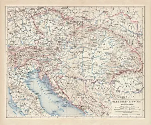
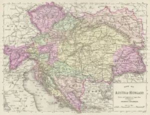
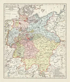
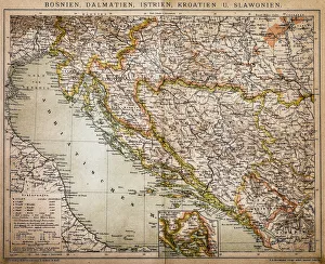
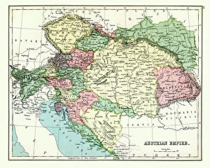
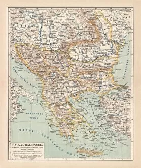
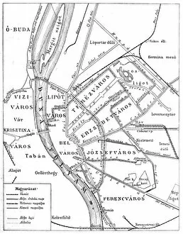
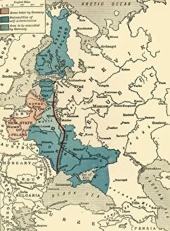
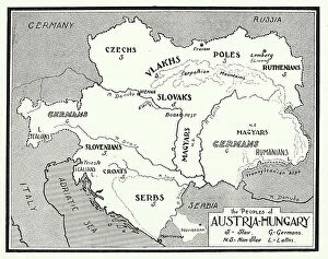
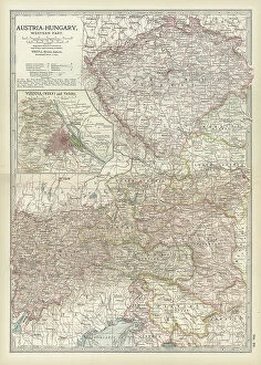
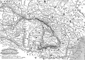
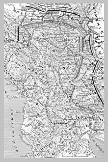
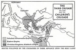
Maps of Hungary Europe are essential for anyone travelling to the country. They provide an overview of the country's geography, showing its major cities, rivers, mountains and other features. They also show the country's borders with neighbouring countries such as Austria, Slovakia and Romania. In addition to physical maps, Hungary has a variety of road maps that show highways and roads throughout the country. These they are be used to plan trips from one city to another or even from one region of Hungary to another. It also provide information about public transportation options in each city or region. Finally, many maps include tourist attractions such as museums and monuments so visitors can plan their own sightseeing itinerary while in Hungary.
+

Our beautiful pictures are available as Framed Prints, Photos, Wall Art and Photo Gifts

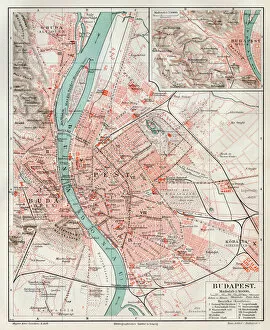
The Maps of Hungary Europe collection from Media Storehouse is a stunning selection of wall art and framed prints that showcase the beauty and history of Hungary. Our collection features a range of maps, including antique maps dating back to the 16th century, as well as more contemporary designs. Each print in our collection has been carefully selected for its quality and historical significance, making it an ideal choice for anyone interested in Hungarian culture or European history. Whether you're looking to add some color to your home or office decor, or simply want to learn more about this fascinating country, these prints are sure to impress. From detailed topographical maps to artistic renderings of Budapest's iconic landmarks, there is something for everyone in this diverse collection. So why not explore the Maps of Hungary Europe collection today and discover all that this beautiful country has to offer?
+

What are Maps of Hungary Europe art prints?

Maps of Hungary Europe art prints are high-quality reproductions of vintage and contemporary maps depicting the geography, topography, and history of Hungary. These prints showcase the intricate details of Hungary's cities, towns, rivers, mountains, and landmarks in stunning clarity. They are perfect for anyone who loves to explore new places or has an interest in Hungarian culture. These art prints come in a variety of sizes and styles to suit different tastes and decor preferences. Some feature colorful illustrations while others have a more minimalist design. They can be framed or hung as-is on your wall to add a touch of sophistication to any room. Whether you're looking for a unique gift for someone special or want to decorate your own home with something meaningful and beautiful, Maps of Hungary Europe art prints from Media Storehouse are an excellent choice. With their exceptional quality and attention to detail, these prints will bring joy and inspiration into your life for years to come.
+

What Maps of Hungary Europe art prints can I buy from Media Storehouse?

We offer a wide range of Maps of Hungary Europe art prints that are perfect for those who love history, geography or simply appreciate the beauty of maps. You can choose from vintage maps dating back to the 18th century, as well as more modern and contemporary designs. Some popular options include detailed topographic maps that showcase Hungary's diverse landscapes, including mountains, rivers and lakes. Other designs feature intricate city plans that highlight Budapest's stunning architecture and landmarks. Whether you're looking for a unique piece of wall art for your home or office, or a thoughtful gift for someone special, we have something to suit every taste and budget. With high-quality printing techniques and premium materials used in each print, you can be sure that your chosen map will look stunning on any wall.
+

How do I buy Maps of Hungary Europe art prints?

To buy Maps of Hungary Europe art prints from Media Storehouse, you can browse our extensive collection of maps and select the one that catches your eye. Once you have found the map you want to purchase, simply add it to your cart and proceed to checkout. You will be prompted to enter your shipping information and payment details before finalizing your order. We offer a variety of sizes for their art prints, so make sure to choose the size that best fits your needs. We also offer different framing options if you prefer a framed print. If you have any questions or concerns about purchasing Maps of Hungary Europe art prints from Media Storehouse, they have a customer service team available to assist you. Simply reach out via email or phone and they will be happy to help guide you through the process.
+

How much do Maps of Hungary Europe art prints cost?

We offer a wide range of Maps of Hungary Europe art prints at varying prices. Our collection includes vintage and contemporary maps that showcase the beauty and history of Hungary and its surrounding regions. The cost of our Maps of Hungary Europe art prints depends on several factors such as size, framing options, and printing materials. We have different sizes available to suit your preferences, from small to large formats. Our high-quality paper prints are perfect for those who want an affordable yet stunning piece of wall decor. For those looking for a more premium option, we also offer canvas prints that add depth and texture to the artwork. Regardless of your budget or taste in style, you can find a Map of Hungary Europe art print that suits your needs at Media Storehouse without compromising quality or aesthetics.
+

How will my Maps of Hungary Europe art prints be delivered to me?

We take great care in ensuring that your Maps of Hungary Europe art prints are delivered to you safely and securely. We use high-quality packaging materials to protect your artwork during transit, so it arrives at your doorstep in pristine condition. We partner with reliable shipping carriers who offer a range of delivery options to suit your needs. Once you place an order for your Maps of Hungary Europe art prints, we will process it promptly and dispatch it as soon as possible. You can track the progress of your shipment using the tracking number provided by our shipping carrier. If there are any issues or delays with delivery, our customer service team is always available to assist you and provide updates on the status of your order. You can expect a hassle-free delivery experience when ordering from Media Storehouse. We pride ourselves on delivering quality products and exceptional customer service every time.