Fraud Blocker Skip to main content

Home > Europe > Montenegro > Maps

Maps Collection

Maps of Montenegro Europe are essential for travelers and locals alike

Choose a picture from our Maps Collection for your Wall Art and Photo Gifts

43 items

Background imageMaps Collection: Bosnia and Montenegro map 1893

Bosnia and Montenegro map 1893
Illustration of a Bosnia and Montenegro map 1893

Background imageMaps Collection: Austro-Hungarian Empire, Habsburg Monarchy, lithograph, published in 1877

Austro-Hungarian Empire, Habsburg Monarchy, lithograph, published in 1877
Ancient map of Austro-Hungarian Empire. Habsburg Monarchy. Lithograph, published in 1877

Background imageMaps Collection: The Balkan States After the Wars of 1912-13, (c1920). Creator: John Bartholomew & Son

The Balkan States After the Wars of 1912-13, (c1920). Creator: John Bartholomew & Son
The Balkan States After the Wars of 1912-13, (c1920). Showing Acquisitions of Territory in Darker Tints. Map of the Balkans: Bosnia, Montenegro, Servia (Serbia), Albania, Roumania (Romania)

Background imageMaps Collection: Portulan representing the Mediterranean basin (the coasts of Italy)

Portulan representing the Mediterranean basin (the coasts of Italy, southern France and northern Africa)
VEN5027752 Portulan representing the Mediterranean basin (the coasts of Italy, southern France and northern Africa). The city of Venice, Marseille and Budva (= Budua)

Background imageMaps Collection: Balkan Peninsula in 1878, lithograph

Balkan Peninsula in 1878, lithograph
Ancient map Balkan. The political classification of the Balkan Peninsula after the Treaty of Berlin in 1878. Lithograph, published in 1878

Background imageMaps Collection: Bosnia, dalmatia, istria, croatia, slavonia

Bosnia, dalmatia, istria, croatia, slavonia
Antique illustration of a Bosnia, dalmatia, istria, croatia, slavonia map

Background imageMaps Collection: Map of the Herzegovina, Bosnia, Servia and Montenegro (engraving)

Map of the Herzegovina, Bosnia, Servia and Montenegro (engraving)
1105886 Map of the Herzegovina, Bosnia, Servia and Montenegro (engraving) by European School, (19th century); Private Collection; (add.info.: Map of the Herzegovina, Bosnia, Servia and Montenegro)

Background imageMaps Collection: Map of the Herzegovina, Bosnia, Servia and Montenegro, 1876. Creator: Unknown

Map of the Herzegovina, Bosnia, Servia and Montenegro, 1876. Creator: Unknown
Map of the Herzegovina, Bosnia, Servia and Montenegro, 1876. Map showing the theatre of war of the Herzegovina Uprising. Reference: The names are spelt agreably to English pronunciation

Background imageMaps Collection: Panorama du theatre des operations des armees alliees, 1916. Creator: Unknown

Panorama du theatre des operations des armees alliees, 1916. Creator: Unknown
Panorama du theatre des operations des armees alliees (Francais, anglais, serbes, russes et Italiens) de la frontiere d'Albanie au golfe de Cavala, 1916. From "Collection de la Guerre IV

Background imageMaps Collection: Historical map of the Ottoman Empire (Turkey), European part, 1897

Historical map of the Ottoman Empire (Turkey), European part, 1897
Historical map of European part of the Ottoman Empire (Turkey) at the end of the 19th century. Lithograph, published in 1897

Background imageMaps Collection: Map of Romania, Serbia, Montenegro, and Bulgaria 19th Century

Map of Romania, Serbia, Montenegro, and Bulgaria 19th Century
Vintage engraving of a Map of Romania, Serbia, Montenegro, and Bulgaria 19th Century, European Turkey

Background imageMaps Collection: Austria-Hungary and Neighbouring Lands - Map, 1920. Creator: John Bartholomew & Son

Austria-Hungary and Neighbouring Lands - Map, 1920. Creator: John Bartholomew & Son
Austria-Hungary and Neighbouring Lands, c1914, (c1920). Map of the Austro-Hungarian Empire and surrounding countries at start of the First World War

Background imageMaps Collection: Montenegro Vector Map

Montenegro Vector Map
Highly detailed vector map of Montenegro. File was created on October 25, 2011. The colors in the.eps-file are ready for print (CMYK). Included files: EPS (v8) and Hi-Res JPG

Background imageMaps Collection: Map of Bosnia and Montenegro 1900

Map of Bosnia and Montenegro 1900
Meyers hand-Atlas Leipzig und Wien Verlag des Bibliographischen Instituts 1900

Background imageMaps Collection: Antique map of Serbia, Novi Pazar and Montenegro

Antique map of Serbia, Novi Pazar and Montenegro
Illustration of a Antique map of Serbia, Novi Pazar and Montenegro

Background imageMaps Collection: The 'Mouth'of Cattaro, the only seaport entrance into Montenegro (litho)

The "Mouth"of Cattaro, the only seaport entrance into Montenegro (litho)
7171102 The " Mouth" of Cattaro, the only seaport entrance into Montenegro (litho) by American School, (20th century); Private Collection; (add.info.: The " Mouth" of Cattaro)

Background imageMaps Collection: Map of Bosnia with details of the areas occupied by minority ethnic groups, 1910 (pen

Map of Bosnia with details of the areas occupied by minority ethnic groups, 1910 (pen
CHT344067 Map of Bosnia with details of the areas occupied by minority ethnic groups, 1910 (pen, ink & w/c) by French School, (20th century); Archives du Ministere des Affaires Etrangeres, Paris

Background imageMaps Collection: The European Demonstration on the Adriatic Coast, Map of the Albanian and Montenegrin Frontier

The European Demonstration on the Adriatic Coast, Map of the Albanian and Montenegrin Frontier (engraving)
1106901 The European Demonstration on the Adriatic Coast, Map of the Albanian and Montenegrin Frontier (engraving) by English School

Background imageMaps Collection: Map of the Kingdom of Dalmatia (present-day Croatia and Montenegro)

Map of the Kingdom of Dalmatia (present-day Croatia and Montenegro)
LRI4711368 Map of the Kingdom of Dalmatia (present-day Croatia and Montenegro), on the coast of the Gulf of Venice (Adriatic Sea) (Engraving, 1717) by Nolin

Background imageMaps Collection: Balkan States

Balkan States
Map of Rumania, Bulgaria, Serbia, Montenegro

Background imageMaps Collection: Map To Illustrate the Eastern Battle Fronts, 1919. Creator: George Philip & Son Ltd

Map To Illustrate the Eastern Battle Fronts, 1919. Creator: George Philip & Son Ltd
Map To Illustrate the Eastern Battle Fronts, 1919. Map showing areas of eastern Europe and the Balkans which saw fighting during the First World War, 1914-1919, including Italy, Austria-Hungary

Background imageMaps Collection: Map To Illustrate the Serbian Retreat, 1919. Creator: George Philip & Son Ltd

Map To Illustrate the Serbian Retreat, 1919. Creator: George Philip & Son Ltd
Map To Illustrate the Serbian Retreat, 1919. During the Serbian armys 1915 retreat through the mountains of Albania in the First World War, some 240, 000 died from cold, starvation, disease

Background imageMaps Collection: Balkan States: Romania, Bulgaria, Serbia and Montenegro, lithograph, published 1897

Balkan States: Romania, Bulgaria, Serbia and Montenegro, lithograph, published 1897
Ancient map of the Balkan States: Romania, Bulgaria, Serbia and Montenegro. Lithograph, published in 1897

Background imageMaps Collection: Rumania, Bulgaria, Serva and Montenegro, c1906, (1907)

Rumania, Bulgaria, Serva and Montenegro, c1906, (1907). From The Worlds History, Volume V, by Dr. H. F. Helmolt. [William Heinemann, London, 1907]

Background imageMaps Collection: Montenegro country map

Montenegro country map
2011 edition

Background imageMaps Collection: Austro-Hungarian Monarchy map from 1896

Austro-Hungarian Monarchy map from 1896
illustration of a Austro-Hungarian Monarchy map from 1896

Background imageMaps Collection: Belovar-koros, Croatio map from 1893

Belovar-koros, Croatio map from 1893
Antique illustration of a Belovar-koros, Croatio map from 1893

Background imageMaps Collection: SAN STEFANO TREATY MAP. The first publication of the map showing the territorial

SAN STEFANO TREATY MAP. The first publication of the map showing the territorial changes effected by the treaty between Russia and Turkey signed at San Stefano, 3 March 1878

Background imageMaps Collection: Montenegro, Relief Map

Montenegro, Relief Map
Relief map of Montenegro. This map was processed from elevation data

Background imageMaps Collection: Montenegro, Relief Map With Border and Mask

Montenegro, Relief Map With Border and Mask
Relief map of Montenegro (with border and mask). This image was compiled from data acquired by landsat 5 & 7 satellites combined with elevation data

Background imageMaps Collection: 1690, Coronelli Map of Montenegro, topography, cartography, geography, land, illustration

1690, Coronelli Map of Montenegro, topography, cartography, geography, land, illustration
1690, Coronelli Map of Montenegro

Background imageMaps Collection: Bosnia and Montenegro, lithograph, published in 1881

Bosnia and Montenegro, lithograph, published in 1881
Ancient map of Bosnia and Montenegro. Lithograph, published in 1881

Background imageMaps Collection: Balkan States, lithograph, published in 1878

Balkan States, lithograph, published in 1878
Ancient map of the Balkan States: Romania, Bulgaria, Serbia and Montenegro. Lithograph, published in 1878

Background imageMaps Collection: Map of Rumania Bulgaria 1896

Map of Rumania Bulgaria 1896
Map of Rumania, Bulgaria, Serbia, Montenegro

Background imageMaps Collection: Bosnia and Montenegro map 1895

Bosnia and Montenegro map 1895
Meyers Konversations-Lexikon. Ein Nachschlagewerk des allgemeinen Wissens, 5th edition 17 volumes Bibliographisches Institut - Leipzig 1895-1897

Background imageMaps Collection: Turkey map 1895

Turkey map 1895
Meyers Konversations-Lexikon. Ein Nachschlagewerk des allgemeinen Wissens, 5th edition 17 volumes Bibliographisches Institut - Leipzig 1895-1897

Background imageMaps Collection: Hungary and Galicia

Hungary and Galicia
Antique Illustration map of a Hungary and Galicia

Background imageMaps Collection: Map of Romania, Serbia, Bulgaria, Montenegro, 1899

Map of Romania, Serbia, Bulgaria, Montenegro, 1899

Background imageMaps Collection: Map of Austria-Hungary, Greece, Serbia, Bosnia and Herzegovina, Romania, Bulgaria

Map of Austria-Hungary, Greece, Serbia, Bosnia and Herzegovina, Romania, Bulgaria, Macedonia, Montenegro and Crete, Albania, Bulgaria, 1899

Background imageMaps Collection: Map of Montenegro, Serbia, Macedonia, Northern Greece, Bulgaria, Albania, Western Turkey

Map of Montenegro, Serbia, Macedonia, Northern Greece, Bulgaria, Albania, Western Turkey, 1899

Background imageMaps Collection: Map of Bosnia and Herzegovina, Montenegro, Serbia, 1899

Map of Bosnia and Herzegovina, Montenegro, Serbia, 1899

Background imageMaps Collection: Montenegro, Relief Map

Montenegro, Relief Map
Relief map of Montenegro. This map was processed from elevation data

Background imageMaps Collection: Montenegro, Satellite Image

Montenegro, Satellite Image
Satellite view of Montenegro. This image was compiled from data acquired by LANDSAT satellite


All Professionally Made to Order for Quick Shipping


-

Maps Collection

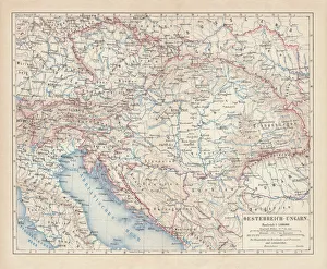
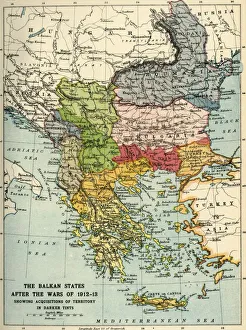
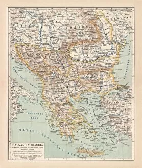
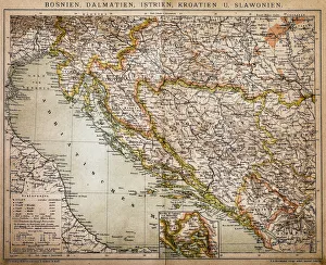
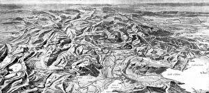
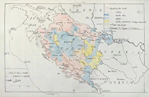
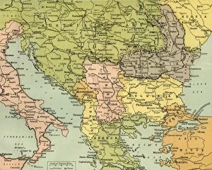
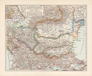
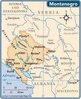
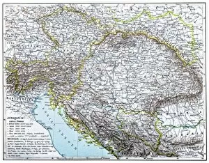
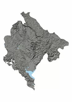
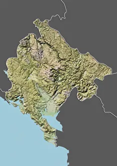
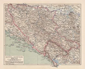
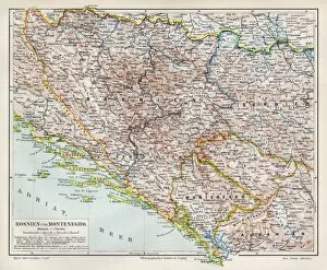
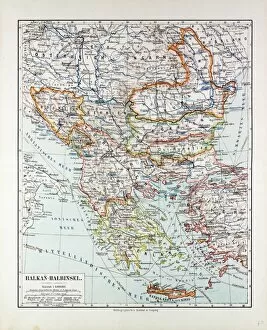
Maps of Montenegro Europe are essential for travelers and locals alike. This small country is situated in the southeastern part of the continent, bordered by Croatia, Bosnia and Herzegovina, Serbia, Kosovo, and Albania. Montenegro has a rugged terrain with mountains dominating much of its landscape. Its coastline along the Adriatic Sea is dotted with beautiful beaches and charming fishing villages, and are help visitors find their way around this picturesque country as they explore its many attractions such as medieval towns, national parks, ski resorts and more. With a map in hand it’s easy to navigate Montenegro’s winding roads or take advantage of its public transportation system to get from one place to another. It also provide an overview of the country’s geography so visitors can plan their trips accordingly.
+

Our beautiful pictures are available as Framed Prints, Photos, Wall Art and Photo Gifts

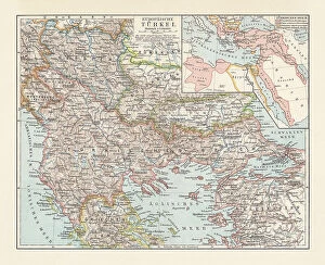
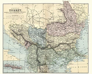
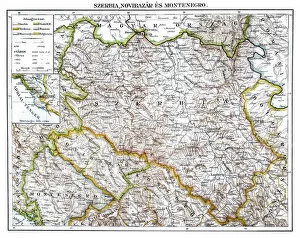
The Maps of Montenegro Europe collection is a stunning and informative selection of wall art and framed prints available from Media Storehouse. Our collection features a range of maps that showcase the geography, topography, and history of Montenegro, one of Europe's most beautiful countries. These maps are not only visually appealing but also provide valuable insights into the country's past and present. The Maps of Montenegro Europe collection includes antique maps dating back to the 18th century as well as modern-day cartography. Some highlights include detailed city plans, topographical charts, and historical maps that illustrate the region's rich cultural heritage. Whether you're looking for a unique piece to decorate your home or office or want to learn more about this fascinating country, these prints are an excellent choice. The Maps of Montenegro Europe collection offers something for everyone interested in geography or history. With high-quality printing on archival paper using fade-resistant inks, these prints will last for years to come while adding beauty and knowledge to any space they adorn.
+

What are Maps of Montenegro Europe art prints?

Maps of Montenegro Europe art prints are high-quality reproductions of maps depicting the geography and topography of Montenegro, a small country located in southeastern Europe. These prints showcase the intricate details and features of the region, including its mountains, rivers, cities, and landmarks. These art prints are perfect for anyone interested in history, geography or travel. They can be used to decorate homes or offices with a unique touch that reflects one's interests and passions. Additionally, they make great gifts for friends or family members who share similar interests. Maps of Montenegro Europe art prints come in various sizes and styles to suit different preferences. Some feature antique designs while others have modern interpretations. Regardless of style preference, these art prints offer an excellent way to appreciate the beauty and complexity of this fascinating country from afar.
+

What Maps of Montenegro Europe art prints can I buy from Media Storehouse?

We offer a wide range of Maps of Montenegro Europe art prints that you can purchase. These maps are available in various sizes and styles, including vintage, modern, and antique designs. You can choose from different types of maps such as political maps, physical maps, topographical maps, roadmaps or city plans. The collection includes detailed and accurate depictions of the country's geography with its mountains ranges, rivers and lakes. Some prints also feature historical landmarks like fortresses or churches which provide an insight into Montenegro's rich cultural heritage. Whether you're looking for a map to display in your home or office space or want to gift it to someone who loves travel and history - Media Storehouse has something for everyone. Their high-quality printing ensures that the colors are vibrant and long-lasting so that you can enjoy your artwork for years to come.
+

How do I buy Maps of Montenegro Europe art prints?

To purchase Maps of Montenegro Europe art prints from Media Storehouse, you can browse our extensive collection online. Simply search for "Maps of Montenegro" in the search bar on our website and select the print that best suits your needs. Once you have selected your desired print, add it to your cart and proceed to checkout. During checkout, you will be prompted to enter your shipping information and payment details. After completing these steps, simply confirm your order and wait for it to arrive at your doorstep. We offer a wide range of high-quality art prints featuring maps of different regions around the world. Their selection includes both vintage and modern styles, so there is something for everyone's taste. Whether you are looking to decorate your home or office space with unique artwork or searching for a thoughtful gift idea for someone special, Maps of Montenegro Europe art prints from Media Storehouse are an excellent choice.
+

How much do Maps of Montenegro Europe art prints cost?

We offer a wide range of Maps of Montenegro Europe art prints at varying prices. The cost of these prints depends on several factors such as the size, quality, and type of print selected by the customer. You can choose from different sizes ranging from small to large and also select their preferred material for printing. The price range for Maps of Montenegro Europe art prints is quite affordable and caters to customers with different budgets. These maps are perfect for those who love travelling or have an interest in geography. They make great additions to any home or office space and are sure to impress visitors. Media Storehouse takes pride in offering high-quality products that meet the needs and preferences of its customers. With a vast collection of Maps of Montenegro Europe art prints available, you can easily find one that suits their taste while staying within budget.
+

How will my Maps of Montenegro Europe art prints be delivered to me?

Your Maps of Montenegro Europe art prints will be delivered to you in a safe and secure manner. We use high-quality packaging materials to ensure that your artwork arrives in pristine condition. Our delivery partners are reliable and efficient, ensuring that your order is delivered on time. We offer various shipping options depending on your location and preferences. You can choose standard or express delivery services, with tracking available for all orders. We also provide international shipping for our customers outside the UK. We take great care in handling and delivering your artwork. We understand the value of these pieces as decorative items or gifts, which is why we make sure they arrive at their destination without any damage or delay. You can rest assured that your Maps of Montenegro Europe art prints will be handled with care from production to delivery.