Home > Africa > Senegal > Maps
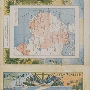
'Map, Dakar - St Louis; L'Ouest Africain, 1914. Creator: Unknown

![]()
Wall Art and Photo Gifts from Heritage Images
'Map, Dakar - St Louis; L'Ouest Africain, 1914. Creator: Unknown
'Map, Dakar - St Louis; L'Ouest Africain, 1914. From "Grande Geographie Bong Illustree", 1914
Heritage Images features heritage image collections
Media ID 36295517
© The Print Collector/Heritage Images
Atlantic Ocean Cartography Colonies Colony Map Making Mapmaking Ocean Senegal Senegalese West Africa West African
FEATURES IN THESE COLLECTIONS
> Africa
> Senegal
> Related Images
> Africa
> Senegal
> Saint-Louis
> Africa
> Senegal
> Senegal Heritage Sites
> Island of Saint-Louis
EDITORS COMMENTS
This black and white map print, titled 'Map, Dakar-St. Louis; L'Ouest Africain, 1914,' is an intriguing glimpse into the colonial era of West Africa. The map, of unknown origin, was published in the French magazine 'Grande Geographie Bong Illustree' in 1914. It depicts the coastal region of Senegal, specifically the areas surrounding Dakar and St. Louis, with meticulous detail. The map is a testament to the advanced cartography and geographical knowledge of the early 20th century. It highlights various geographical features, including bays, islands, rivers, and towns, with clear and precise labeling. The Atlantic Ocean is prominently featured, its waves lapping at the shores of the African continent. The map also reflects the colonial influence of France in the region, with the country's flag proudly displayed in several locations. The French colonial empire extended across much of West Africa at the time, and this map serves as a visual representation of its reach. Despite the colonial overtones, the map is a valuable historical artifact, offering insights into the geography and cartography of the time. It provides a glimpse into the world as it was perceived during the early 1900s, and serves as a reminder of the rich history and cultural exchange that took place between Africa and Europe during this period. The map is a fascinating addition to any collection of historical maps or Africana, and is sure to spark curiosity and conversation among viewers.
MADE IN THE UK
Safe Shipping with 30 Day Money Back Guarantee
FREE PERSONALISATION*
We are proud to offer a range of customisation features including Personalised Captions, Color Filters and Picture Zoom Tools
SECURE PAYMENTS
We happily accept a wide range of payment options so you can pay for the things you need in the way that is most convenient for you
* Options may vary by product and licensing agreement. Zoomed Pictures can be adjusted in the Basket.