Greetings Card > Universal Images Group (UIG) > Universal Images Group > Satellite and Aerial > Planet Observer 4
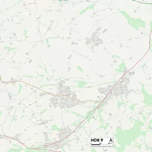
Greetings Card : Slovakia, Relief Map with Border and Mask


![]()
Cards from Universal Images Group (UIG)
Slovakia, Relief Map with Border and Mask
Relief map of Slovakia (with border and mask). This image was compiled from data acquired by landsat 5 & 7 satellites combined with elevation data
Universal Images Group (UIG) manages distribution for many leading specialist agencies worldwide
Media ID 9618591
© Planet Observer/UIG
Carpathian Mountains Danube River Relief Map Slovakia Bratislava Satellite View
Greetings Card (A5)
Discover the beauty of Slovakia with our unique Media Storehouse Greetings Cards. Featuring a captivating relief map of Slovakia, complete with its distinct border and mask, this card is a perfect representation of the country's natural terrain. Meticulously compiled from data acquired by Landsat 5 & 7 satellites and combined with elevation data, this card is a geography lover's dream. Send this thoughtful and visually stunning card to your loved ones and let them explore the wonders of Slovakia from the comfort of their own home.
Create your own greetings card. Size when folded is A5 (14.5x21cm or 5.7x8.3 inches)
Greetings Cards suitable for Birthdays, Weddings, Anniversaries, Graduations, Thank You and much more
Estimated Image Size (if not cropped) is 21cm x 14.5cm (8.3" x 5.7")
Estimated Product Size is 21cm x 29cm (8.3" x 11.4")
These are individually made so all sizes are approximate
Artwork printed orientated as per the preview above, with landscape (horizontal) orientation to match the source image.
EDITORS COMMENTS
This print showcases the stunning relief map of Slovakia, offering a unique perspective on the country's topography. Compiled from data acquired by Landsat 5 & 7 satellites combined with elevation data, this image provides an intricate and detailed representation of Slovakia's physical geography. The photograph captures the diverse landscape of Slovakia with utmost precision and clarity. From the vibrant colors that depict various elevations to the intricate border and mask that define its boundaries, every aspect of this relief map is meticulously portrayed. As we delve into this image, our eyes are drawn to prominent features such as the majestic Carpathian Mountains dominating much of Slovakia's northern region. The Danube River gracefully meanders through the landscape, adding a touch of serenity amidst nature's grandeur. With no people in sight, this photograph allows us to immerse ourselves fully in Slovakia's natural beauty. It invites us to explore its enchanting forests, picturesque valleys, and charming towns at our own pace. Whether you have an affinity for cartography or simply appreciate Europe's breathtaking landscapes, this horizontal print will undoubtedly captivate your imagination. Its remarkable detail transports you directly into Slovakian terrain while simultaneously serving as a visually striking piece for any space
MADE IN THE UK
Safe Shipping with 30 Day Money Back Guarantee
FREE PERSONALISATION*
We are proud to offer a range of customisation features including Personalised Captions, Color Filters and Picture Zoom Tools
SECURE PAYMENTS
We happily accept a wide range of payment options so you can pay for the things you need in the way that is most convenient for you
* Options may vary by product and licensing agreement. Zoomed Pictures can be adjusted in the Basket.